Map of Clark County - Clark County is a county located in the U.S. state of Idaho. Clark County Map showing cities, highways, important places and water bodies. Get Where is Clark County located in the map, major cities in Clark county, population, areas, and places of interest.
Clark County Map, Idaho
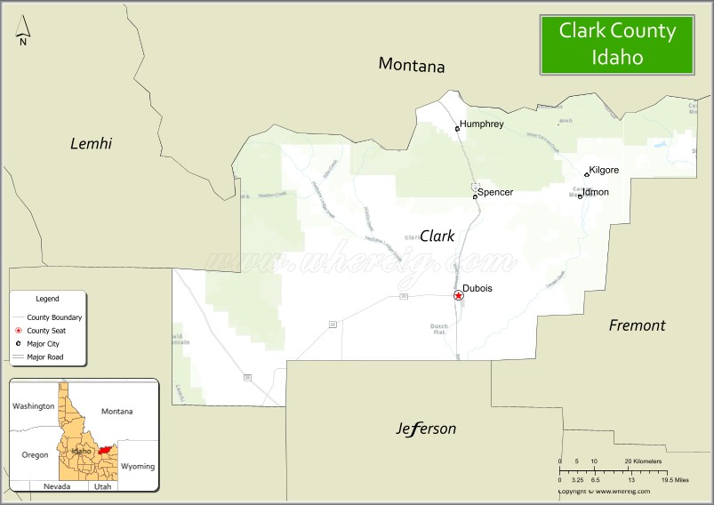
About Clark County Map, Idaho: The map showing the county boundary, county seat, major cities, highways, water bodies and neighbouring counties.
Most Viewed Links
| Idaho Map | Idaho County Map | Idaho Cities Map |
| Idaho Zipcodes | Airports in Idaho | Where is Idaho |
| Idaho Area Codes | Idaho Blank Map | Idaho River Map |
| Idaho Physical Map | Idaho Road Map |
Map of Clark County, Idaho
Clark County is a county located in the U.S. state of Idaho. It's county seat is Dubois. As per 2020 census, the population of Clark County is 792 people and population density is square miles. According to the United States Census Bureau, the county has a total area of 1,765 sq mi (4,571 km2). Clark County was established on 1919.
Clark County Facts
| Continent | North America |
| Country | United States |
| State | Idaho |
| County Seat | Dubois |
| Largest City/Town | Dubois |
| Established | 1919 |
| Total Area | 1,765 sq mi (4,571 sq km) |
| Land Area | 1,764 sq mi (4,569 sq km) |
| Water Area | 1 sq mi (3 sq km) |
| Population | 790 (Census 2020) |
| Population Density | 0.4 people per sq mi |
| Time Zone | Mountain Time Zone (MT) |
| Major Highways | Interstate 15, U.S. Route 20 |
| Major Rivers | Beaver Creek, Red Rock River nearby area |
| Neighboring Counties | Lemhi County, Butte County, Jefferson County, Fremont County, Beaverhead County (Montana) |
| Famous For | Wide-open landscapes, ranching, wildlife habitats, and proximity to Yellowstone and the Centennial Mountains |
| Top Attractions | Camas National Wildlife Refuge nearby area, Centennial Mountains, Dubois Historic District, Red Rock Pass, Beaver Canyon |
| Official Website | Official Website |
About Clark County, Idaho
Clark County is located in eastern Idaho along the Montana border and was established in 1919. The county seat and largest community is Dubois. Clark County is the least populous county in Idaho and is known for expansive high desert valleys, mountain scenery, wildlife refuges, ranching, and outdoor recreation near Yellowstone and the Centennial Mountains. ([en.wikipedia.org](https://en.wikipedia.org/wiki/Clark_County,_Idaho?utm_source=chatgpt.com))
Cities and Communities in Clark County, Idaho
| City/Town | Population | Latitude & Longitude |
|---|---|---|
| Dubois (county seat) | 600+ | 44.1763°N, 112.2308°W |
| Spencer | Mountain Community | 44.3602°N, 112.1866°W |
| Kilgore | Rural Area | 44.3977°N, 111.8822°W |
| Monida Pass Area | Border Region | 44.5580°N, 112.3121°W |
| Humphrey | Agricultural Community | 44.0628°N, 112.2801°W |
| Medicine Lodge Area | Historic Region | 44.6252°N, 112.6347°W |
| Red Rock Valley Area | Scenic Region | 44.5218°N, 112.0459°W |
| Centennial Valley Area | Mountain Region | 44.5610°N, 111.9505°W |
Best Golf Courses in Clark County, Idaho
| Golf Course | Location | Latitude & Longitude |
|---|---|---|
| Jefferson Hills Golf Course | Nearby Rigby | 43.6851°N, 111.9207°W |
| Pinecrest Golf Course | Nearby Idaho Falls | 43.4820°N, 112.0394°W |
| Rexburg Municipal Golf Course | Nearby Rexburg | 43.8255°N, 111.7781°W |
| Teton Lakes Golf Course | Nearby Rexburg | 43.8502°N, 111.7559°W |
What are Major Roads and Highways in Clark County
Major highways connect Clark County with Montana, Yellowstone National Park, and eastern Idaho transportation corridors.
- Interstate 15 - major north-south interstate through Dubois and Monida Pass
- U.S. Route 20 - regional highway linking eastern Idaho communities
- Monida Pass Road - scenic route crossing the Continental Divide region
- County Scenic Roads - access routes to wildlife refuges and mountain recreation areas
Neighboring Counties of Clark County
- Lemhi County (west)
- Butte County (southwest)
- Jefferson County (south)
- Fremont County (east)
- Beaverhead County, Montana (north)
What are Top Attractions in Clark County, Idaho
The county offers wildlife viewing, mountain scenery, ranchlands, outdoor recreation, and historic travel corridors across eastern Idaho and the Montana borderlands.
| Main Sight Name | City | Famous For |
|---|---|---|
| Camas National Wildlife Refuge Nearby Area | Kilgore Area | Birdwatching, wetlands, and wildlife habitat |
| Centennial Mountains | Northern County Area | Mountain scenery and wilderness recreation |
| Dubois Historic District | Dubois | Historic railroad and ranching heritage |
| Red Rock Pass | Northern Region | Lewis and Clark Expedition history |
| Beaver Canyon | Countywide | Hiking, camping, and scenic landscapes |
| Medicine Lodge Historic Area | Western Region | Native American and pioneer history |
| Monida Pass | Northern Border Area | Scenic mountain drives and historic transportation route |
| High Desert Wildlife Areas | Countywide | Wildlife photography and open landscapes |
| Centennial Valley Scenic Routes | Countywide | Mountain and prairie photography |
| Outdoor Camping Areas | Countywide | Remote recreation and stargazing opportunities |
Distance from Clark County to Nearby Cities
The following distances are measured by road (driving).
- Dubois to Idaho Falls, Idaho - 44 mi (71 km)
- Dubois to Rexburg, Idaho - 36 mi (58 km)
- Dubois to West Yellowstone, Montana - 94 mi (151 km)
- Dubois to Pocatello, Idaho - 96 mi (154 km)
- Dubois to Jackson, Wyoming - 123 mi (198 km)
- Dubois to Yellowstone National Park - 108 mi (174 km)
- Dubois to Boise, Idaho - 323 mi (520 km)
- Dubois to Salt Lake City, Utah - 255 mi (410 km)
- Dubois to Missoula, Montana - 243 mi (391 km)
- Dubois to Denver, Colorado - 606 mi (975 km)
- Dubois to Spokane, Washington - 565 mi (909 km)
- Dubois to Seattle, Washington - 720 mi (1,159 km)
References
- Clark County Official Website
- Clark County, Idaho - Wikipedia
- U.S. Census Bureau QuickFacts
- Camas National Wildlife Refuge
- Visit Idaho Tourism
- Ada County Map
- Adams County Map
- Bannock County Map
- Bear Lake County Map
- Benewah County Map
- Bingham County Map
- Blaine County Map
- Boise County Map
- Bonner County Map
- Bonneville County Map
- Boundary County Map
- Butte County Map
- Camas County Map
- Canyon County Map
- Caribou County Map
- Cassia County Map
- Clark County Map
- Clearwater County Map
- Custer County Map
- Elmore County Map
- Franklin County Map
- Fremont County Map
- Gem County Map
- Gooding County Map
- Idaho County Map
- Jefferson County Map
- Jerome County Map
- Kootenai County Map
- Latah County Map
- Lemhi County Map
- Lewis County Map
- Lincoln County Map
- Madison County Map
- Minidoka County Map
- Nez Perce County Map
- Oneida County Map
- Owyhee County Map
- Payette County Map
- Power County Map
- Shoshone County Map
- Teton County Map
- Twin Falls County Map
- Valley County Map
- Washington County Map
- Alabama Counties
- Alaska boroughs
- Arizona Counties
- Arkansas Counties
- California County Map
- Colorado Counties
- Connecticut Counties
- Delaware Counties
- Florida County Map
- Georgia County Map
- Hawaii Counties
- Idaho Counties
- Illinois Counties
- Indiana Counties
- Iowa Counties
- Kansas Counties
- Kentucky Counties
- Louisiana Counties
- Maine Counties
- Maryland Counties
- Massachusetts Counties
- Michigan County Map
- Minnesota Counties
- Mississippi Counties
- Missouri Counties
- Montana Counties
- Nebraska Counties
- Nevada Counties
- New York Counties
- New Hampshire Counties
- New Jersey Counties
- New Mexico Counties
- North Carolina Counties
- North Dakota Counties
- Ohio County Map
- Oklahoma Counties
- Oregon Counties
- Pennsylvania Counties
- Rhode Island Counties
- South Carolina Counties
- South Dakota Counties
- Map of Tennessee
- Texas County Map
- Utah Counties
- Vermont Counties
- Virginia Counties
- Washington Counties
- West Virginia Counties
- Wisconsin Counties
- Wyoming Counties