Map of Lewis County - Lewis County is a county located in the U.S. state of Idaho. Lewis County Map showing cities, highways, important places and water bodies. Get Where is Lewis County located in the map, major cities in Lewis county, population, areas, and places of interest.
Lewis County Map, Idaho
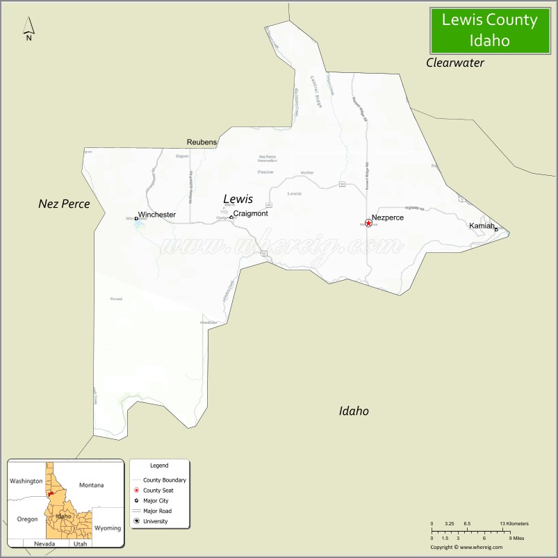
About Lewis County Map, Idaho: The map showing the county boundary, county seat, major cities, highways, water bodies and neighbouring counties.
Most Viewed Links
| Idaho Map | Idaho County Map | Idaho Cities Map |
| Idaho Zipcodes | Airports in Idaho | Where is Idaho |
| Idaho Area Codes | Idaho Blank Map | Idaho River Map |
| Idaho Physical Map | Idaho Road Map |
Map of Lewis County, Idaho
Lewis County is a county located in the U.S. state of Idaho. It's county seat is Nezperce. As per 2020 census, the population of Lewis County is 3715 people and population density is square miles. According to the United States Census Bureau, the county has a total area of 479 sq mi (1,241 km2). Lewis County was established on 1911.
Lewis County Facts
| Continent | North America |
| Country | United States |
| State | Idaho |
| County Seat | Nezperce |
| Largest City/Town | Kamiah |
| Established | 1911 |
| Total Area | 480 sq mi (1,243 sq km) |
| Land Area | 479 sq mi (1,241 sq km) |
| Water Area | 0.9 sq mi (2 sq km) |
| Population | 3,533 (Census 2020) |
| Population Density | 7.4 people per sq mi |
| Time Zone | Pacific Time Zone (PT) |
| Major Highways | U.S. Route 12, U.S. Route 95, Idaho State Highway 64, Idaho State Highway 162 |
| Major Rivers | Clearwater River, Snake River nearby area |
| Neighboring Counties | Nez Perce County, Clearwater County, Idaho County |
| Famous For | Camas Prairie, Nez Perce heritage, agriculture, forests, and scenic rural landscapes |
| Top Attractions | Camas Prairie, Clearwater River, Nez Perce National Historical Park nearby area, Winchester Lake State Park, Craig Mountain nearby region |
| Official Website | Official Website |
About Lewis County, Idaho
Lewis County is located in north-central Idaho and was established in 1911. The county seat is Nezperce, while Kamiah is the largest city. Lewis County is known for scenic prairie landscapes, agricultural communities, Nez Perce cultural heritage, and outdoor recreation along the Clearwater River region. :contentReference[oaicite:0]{index=0}
Cities and Communities in Lewis County, Idaho
| City/Town | Population | Latitude & Longitude |
|---|---|---|
| Kamiah | 1,100+ | 46.2271°N, 116.0265°W |
| Nezperce (county seat) | 500+ | 46.2341°N, 116.2404°W |
| Craigmont | 500+ | 46.2429°N, 116.4729°W |
| Winchester | 300+ | 46.2310°N, 116.6227°W |
| Reubens | Small Community | 46.3224°N, 116.5410°W |
| Slickpoo | Historic Community | 46.2782°N, 116.3321°W |
| Camas Prairie Area | Scenic Region | 46.2751°N, 116.3812°W |
| Clearwater River Valley | River Region | 46.2208°N, 116.0425°W |
Best Golf Courses in Lewis County, Idaho
| Golf Course | Location | Latitude & Longitude |
|---|---|---|
| Clearwater Valley Golf Course | Kamiah Area | 46.2279°N, 116.0287°W |
| Grangeville Centennial Golf Course | Nearby Grangeville | 45.9297°N, 116.1158°W |
| Lewiston Golf & Country Club | Nearby Lewiston | 46.4025°N, 117.0408°W |
| University of Idaho Golf Course | Nearby Moscow | 46.7315°N, 117.0178°W |
What are Major Roads and Highways in Lewis County
Major highways connect Lewis County with the Clearwater River valley, agricultural prairie communities, and north-central Idaho transportation corridors. :contentReference[oaicite:1]{index=1}
- U.S. Route 12 - scenic highway along the Clearwater River corridor
- U.S. Route 95 - major north-south highway through north-central Idaho
- Idaho State Highway 64 - route connecting prairie communities
- Idaho State Highway 162 - regional roadway serving Kamiah and nearby areas
Neighboring Counties of Lewis County
- Nez Perce County (northwest)
- Clearwater County (northeast)
- Idaho County (southeast)
What are Top Attractions in Lewis County, Idaho
The county offers prairie scenery, river recreation, fishing, hiking, historical landmarks, and cultural attractions connected to the Nez Perce region and Lewis and Clark history. :contentReference[oaicite:2]{index=2}
| Main Sight Name | City | Famous For |
|---|---|---|
| Camas Prairie | Countywide | Rolling farmland and scenic prairie landscapes |
| Clearwater River | Kamiah Area | Fishing, rafting, and riverside recreation |
| Nez Perce National Historical Park Nearby Area | Regional Area | Native American and Lewis and Clark history |
| Winchester Lake State Park | Winchester | Camping, boating, and fishing recreation |
| Craig Mountain Nearby Region | Western Area | Wildlife viewing and hiking |
| Historic Downtown Kamiah | Kamiah | Local shops and cultural heritage |
| Nezperce Historic Area | Nezperce | Historic prairie settlement community |
| Clearwater Scenic Byway | Countywide | Scenic drives and river canyon views |
| Lewis and Clark Expedition Sites | Regional Area | Historic exploration landmarks |
| Prairie Agricultural Drives | Countywide | Rural scenery and photography |
Distance from Lewis County to Nearby Cities
The following distances are measured by road (driving).
- Nezperce to Lewiston, Idaho - 72 mi (116 km)
- Nezperce to Moscow, Idaho - 83 mi (134 km)
- Nezperce to Grangeville, Idaho - 28 mi (45 km)
- Nezperce to Coeur d'Alene, Idaho - 154 mi (248 km)
- Nezperce to Spokane, Washington - 162 mi (261 km)
- Nezperce to Boise, Idaho - 271 mi (436 km)
- Nezperce to Missoula, Montana - 220 mi (354 km)
- Nezperce to Seattle, Washington - 393 mi (632 km)
- Nezperce to Portland, Oregon - 365 mi (587 km)
- Nezperce to Salt Lake City, Utah - 593 mi (954 km)
- Nezperce to Denver, Colorado - 905 mi (1,457 km)
- Nezperce to Glacier National Park, Montana - 298 mi (480 km)
References
- Lewis County Official Website
- Lewis County, Idaho - Wikipedia
- U.S. Census Bureau QuickFacts
- Visit Idaho Tourism
- Winchester Lake State Park
- Ada County Map
- Adams County Map
- Bannock County Map
- Bear Lake County Map
- Benewah County Map
- Bingham County Map
- Blaine County Map
- Boise County Map
- Bonner County Map
- Bonneville County Map
- Boundary County Map
- Butte County Map
- Camas County Map
- Canyon County Map
- Caribou County Map
- Cassia County Map
- Clark County Map
- Clearwater County Map
- Custer County Map
- Elmore County Map
- Franklin County Map
- Fremont County Map
- Gem County Map
- Gooding County Map
- Idaho County Map
- Jefferson County Map
- Jerome County Map
- Kootenai County Map
- Latah County Map
- Lemhi County Map
- Lewis County Map
- Lincoln County Map
- Madison County Map
- Minidoka County Map
- Nez Perce County Map
- Oneida County Map
- Owyhee County Map
- Payette County Map
- Power County Map
- Shoshone County Map
- Teton County Map
- Twin Falls County Map
- Valley County Map
- Washington County Map
- Alabama Counties
- Alaska boroughs
- Arizona Counties
- Arkansas Counties
- California County Map
- Colorado Counties
- Connecticut Counties
- Delaware Counties
- Florida County Map
- Georgia County Map
- Hawaii Counties
- Idaho Counties
- Illinois Counties
- Indiana Counties
- Iowa Counties
- Kansas Counties
- Kentucky Counties
- Louisiana Counties
- Maine Counties
- Maryland Counties
- Massachusetts Counties
- Michigan County Map
- Minnesota Counties
- Mississippi Counties
- Missouri Counties
- Montana Counties
- Nebraska Counties
- Nevada Counties
- New York Counties
- New Hampshire Counties
- New Jersey Counties
- New Mexico Counties
- North Carolina Counties
- North Dakota Counties
- Ohio County Map
- Oklahoma Counties
- Oregon Counties
- Pennsylvania Counties
- Rhode Island Counties
- South Carolina Counties
- South Dakota Counties
- Map of Tennessee
- Texas County Map
- Utah Counties
- Vermont Counties
- Virginia Counties
- Washington Counties
- West Virginia Counties
- Wisconsin Counties
- Wyoming Counties