Map of Payette County - Payette County is a county located in the U.S. state of Idaho. Payette County Map showing cities, highways, important places and water bodies. Get Where is Payette County located in the map, major cities in Payette county, population, areas, and places of interest.
Payette County Map, Idaho
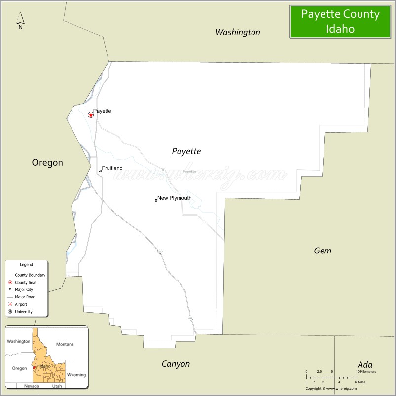
About Payette County Map, Idaho: The map showing the county boundary, county seat, major cities, highways, water bodies and neighbouring counties.
Most Viewed Links
| Idaho Map | Idaho County Map | Idaho Cities Map |
| Idaho Zipcodes | Airports in Idaho | Where is Idaho |
| Idaho Area Codes | Idaho Blank Map | Idaho River Map |
| Idaho Physical Map | Idaho Road Map |
Map of Payette County, Idaho
Payette County is a county located in the U.S. state of Idaho. It's county seat is Payette. As per 2020 census, the population of Payette County is 26350 people and population density is square miles. According to the United States Census Bureau, the county has a total area of 408 sq mi (1,057 km2). Payette County was established on 1917.
Payette County Facts
| Continent | North America |
| Country | United States |
| State | Idaho |
| County Seat | Payette |
| Largest City/Town | Payette |
| Established | 1917 |
| Total Area | 410 sq mi (1,062 sq km) |
| Land Area | 407 sq mi (1,054 sq km) |
| Water Area | 3 sq mi (8 sq km) |
| Population | 25,794 (Census 2020) |
| Population Density | 63 people per sq mi |
| Time Zone | Mountain Time Zone (MT) |
| Major Highways | Interstate 84 nearby area, U.S. Route 95, U.S. Route 30, Idaho State Highway 52 |
| Major Rivers | Snake River, Payette River |
| Neighboring Counties | Washington County, Gem County, Canyon County, Malheur County (Oregon) |
| Famous For | Fruit orchards, agriculture, Payette River recreation, and Idaho-Oregon border communities |
| Top Attractions | Payette River, Kiwanis Park, Scotch Pines Golf Course, Four Rivers Cultural Center nearby area, Snake River recreation |
| Official Website | Official Website |
About Payette County, Idaho
Payette County is located in western Idaho along the Oregon border and was established in 1917. The county seat and largest city is Payette. The county is known for fertile farmland, orchards, river recreation, and its location along the Snake and Payette Rivers in the Treasure Valley region. ([en.wikipedia.org](https://en.wikipedia.org/wiki/Payette_County,_Idaho?utm_source=chatgpt.com))
Cities and Communities in Payette County, Idaho
| City/Town | Population | Latitude & Longitude |
|---|---|---|
| Payette (county seat) | 8,000+ | 44.0782°N, 116.9338°W |
| Fruitland | 5,000+ | 44.0077°N, 116.9163°W |
| New Plymouth | 1,500+ | 43.9691°N, 116.8190°W |
| Parma Nearby Area | Agricultural Region | 43.7868°N, 116.9438°W |
| Ontario Nearby Area | Regional Trade Center | 44.0266°N, 116.9629°W |
| Payette River Valley | Scenic Region | 44.0672°N, 116.9014°W |
| Sand Hollow Area | Rural Community | 43.9862°N, 116.8837°W |
| Apple Valley Area | Orchard Region | 44.0205°N, 116.9740°W |
Best Golf Courses in Payette County, Idaho
| Golf Course | Location | Latitude & Longitude |
|---|---|---|
| Scotch Pines Golf Course | Payette | 44.0718°N, 116.9158°W |
| Rolling Hills Golf Course | Nearby Weiser | 44.2565°N, 116.9660°W |
| River Bend Golf Course | Nearby Wilder | 43.6754°N, 116.9120°W |
| Purple Sage Golf Course | Nearby Caldwell | 43.6628°N, 116.6767°W |
What are Major Roads and Highways in Payette County
Major highways connect Payette County with Boise, eastern Oregon, and agricultural communities throughout western Idaho and the Treasure Valley region. ([en.wikipedia.org](https://en.wikipedia.org/wiki/Payette_County,_Idaho?utm_source=chatgpt.com))
- U.S. Route 95 - major north-south transportation corridor through western Idaho
- U.S. Route 30 - regional highway connecting Payette and Fruitland
- Idaho State Highway 52 - scenic route through farming and orchard areas
- Interstate 84 nearby area - major interstate serving southwestern Idaho and Oregon
Neighboring Counties of Payette County
- Washington County (north)
- Gem County (east)
- Canyon County (south)
- Malheur County, Oregon (west)
What are Top Attractions in Payette County, Idaho
The county offers river recreation, parks, orchards, cultural attractions, fishing, camping, and scenic agricultural landscapes throughout western Idaho.
| Main Sight Name | City | Famous For |
|---|---|---|
| Payette River | Countywide | Fishing, boating, and scenic river recreation |
| Kiwanis Park | Payette | Family recreation and community events |
| Scotch Pines Golf Course | Payette | Golfing and scenic valley views |
| Four Rivers Cultural Center Nearby Area | Ontario Region | Cultural exhibits and Japanese heritage history |
| Snake River Recreation | Countywide | Fishing, kayaking, and riverside camping |
| Historic Downtown Payette | Payette | Historic buildings and local shops |
| Fruitland Community Parks | Fruitland | Sports fields and family recreation |
| Orchard Scenic Drives | Countywide | Fruit orchards and seasonal blossom scenery |
| New Plymouth Historic Area | New Plymouth | Historic irrigation and farming heritage |
| Treasure Valley Scenic Routes | Countywide | Farmland and mountain views |
Distance from Payette County to Nearby Cities
The following distances are measured by road (driving).
- Payette to Boise, Idaho - 62 mi (100 km)
- Payette to Caldwell, Idaho - 42 mi (68 km)
- Payette to Nampa, Idaho - 52 mi (84 km)
- Payette to Weiser, Idaho - 15 mi (24 km)
- Payette to Baker City, Oregon - 95 mi (153 km)
- Payette to Twin Falls, Idaho - 181 mi (291 km)
- Payette to Salt Lake City, Utah - 398 mi (641 km)
- Payette to Reno, Nevada - 334 mi (538 km)
- Payette to Portland, Oregon - 367 mi (591 km)
- Payette to Spokane, Washington - 336 mi (541 km)
- Payette to Seattle, Washington - 514 mi (827 km)
- Payette to Denver, Colorado - 861 mi (1,386 km)
References
- Payette County Official Website
- Payette County, Idaho - Wikipedia
- U.S. Census Bureau QuickFacts
- Visit Idaho Tourism
- Treasure Valley Regional Information
- Ada County Map
- Adams County Map
- Bannock County Map
- Bear Lake County Map
- Benewah County Map
- Bingham County Map
- Blaine County Map
- Boise County Map
- Bonner County Map
- Bonneville County Map
- Boundary County Map
- Butte County Map
- Camas County Map
- Canyon County Map
- Caribou County Map
- Cassia County Map
- Clark County Map
- Clearwater County Map
- Custer County Map
- Elmore County Map
- Franklin County Map
- Fremont County Map
- Gem County Map
- Gooding County Map
- Idaho County Map
- Jefferson County Map
- Jerome County Map
- Kootenai County Map
- Latah County Map
- Lemhi County Map
- Lewis County Map
- Lincoln County Map
- Madison County Map
- Minidoka County Map
- Nez Perce County Map
- Oneida County Map
- Owyhee County Map
- Payette County Map
- Power County Map
- Shoshone County Map
- Teton County Map
- Twin Falls County Map
- Valley County Map
- Washington County Map
- Alabama Counties
- Alaska boroughs
- Arizona Counties
- Arkansas Counties
- California County Map
- Colorado Counties
- Connecticut Counties
- Delaware Counties
- Florida County Map
- Georgia County Map
- Hawaii Counties
- Idaho Counties
- Illinois Counties
- Indiana Counties
- Iowa Counties
- Kansas Counties
- Kentucky Counties
- Louisiana Counties
- Maine Counties
- Maryland Counties
- Massachusetts Counties
- Michigan County Map
- Minnesota Counties
- Mississippi Counties
- Missouri Counties
- Montana Counties
- Nebraska Counties
- Nevada Counties
- New York Counties
- New Hampshire Counties
- New Jersey Counties
- New Mexico Counties
- North Carolina Counties
- North Dakota Counties
- Ohio County Map
- Oklahoma Counties
- Oregon Counties
- Pennsylvania Counties
- Rhode Island Counties
- South Carolina Counties
- South Dakota Counties
- Map of Tennessee
- Texas County Map
- Utah Counties
- Vermont Counties
- Virginia Counties
- Washington Counties
- West Virginia Counties
- Wisconsin Counties
- Wyoming Counties