Map of Blaine County - Blaine County is a county located in the U.S. state of Idaho. Blaine County Map showing cities, highways, important places and water bodies. Get Where is Blaine County located in the map, major cities in Blaine county, population, areas, and places of interest.
Blaine County Map, Idaho
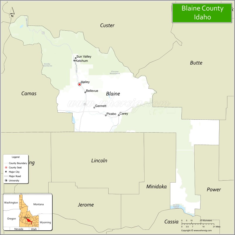
About Blaine County Map, Idaho: The map showing the county boundary, county seat, major cities, highways, water bodies and neighbouring counties.
Most Viewed Links
| Idaho Map | Idaho County Map | Idaho Cities Map |
| Idaho Zipcodes | Airports in Idaho | Where is Idaho |
| Idaho Area Codes | Idaho Blank Map | Idaho River Map |
| Idaho Physical Map | Idaho Road Map |
Map of Blaine County, Idaho
Blaine County is a county located in the U.S. state of Idaho. It's county seat is Hailey. As per 2020 census, the population of Blaine County is 24766 people and population density is square miles. According to the United States Census Bureau, the county has a total area of 2,645 sq mi (6,851 km2). Blaine County was established on 1895.
Blaine County Facts
| Continent | North America |
| Country | United States |
| State | Idaho |
| County Seat | Hailey |
| Largest City/Town | Hailey |
| Established | 1895 |
| Total Area | 2,661 sq mi (6,892 sq km) |
| Land Area | 2,644 sq mi (6,848 sq km) |
| Water Area | 17 sq mi (44 sq km) |
| Population | 24,272 (Census 2020) |
| Population Density | 9 people per sq mi |
| Time Zone | Mountain Time Zone (MT) |
| Major Highways | State Highway 75, U.S. Route 20, State Highway 78 |
| Major Rivers | Big Wood River, Little Wood River |
| Neighboring Counties | Custer County, Butte County, Bingham County, Lincoln County, Camas County, Elmore County |
| Famous For | Sun Valley Resort, skiing, mountain recreation, Ernest Hemingway history, and scenic Sawtooth landscapes |
| Top Attractions | Sun Valley Resort, Bald Mountain, Sawtooth National Recreation Area nearby region, Craters of the Moon nearby area, Hemingway Memorial |
| Official Website | Official Website |
About Blaine County, Idaho
Blaine County is located in central Idaho and was established in 1895. The county seat and largest city is Hailey. Blaine County is internationally known for Sun Valley Resort, one of the first destination ski resorts in the United States, along with outdoor recreation, mountain scenery, hiking, biking, and cultural ties to author Ernest Hemingway. ([en.wikipedia.org](https://en.wikipedia.org/wiki/Blaine_County,_Idaho?utm_source=chatgpt.com))
Cities and Communities in Blaine County, Idaho
| City/Town | Population | Latitude & Longitude |
|---|---|---|
| Hailey (county seat) | 9,000+ | 43.5196°N, 114.3153°W |
| Ketchum | 3,500+ | 43.6807°N, 114.3637°W |
| Sun Valley | 1,800+ | 43.6971°N, 114.3517°W |
| Bellevue | 2,500+ | 43.4635°N, 114.2606°W |
| Carey | 700+ | 43.3074°N, 113.9445°W |
| Picabo | Historic Community | 43.3077°N, 114.0670°W |
| Gannett | Rural Area | 43.3886°N, 114.1761°W |
| Triumph | Mountain Community | 43.5877°N, 114.2323°W |
Best Golf Courses in Blaine County, Idaho
| Golf Course | Location | Latitude & Longitude |
|---|---|---|
| Trail Creek Golf Course | Sun Valley | 43.6848°N, 114.3492°W |
| Elkhorn Golf Club | Sun Valley | 43.7027°N, 114.3299°W |
| Bigwood Golf Course | Ketchum | 43.6824°N, 114.3689°W |
| River's Edge Golf Club | Burley Nearby Area | 42.5657°N, 113.7845°W |
What are Major Roads and Highways in Blaine County
Major highways connect Blaine County with mountain recreation areas, central Idaho communities, and scenic tourism destinations. ([en.wikipedia.org](https://en.wikipedia.org/wiki/Blaine_County,_Idaho?utm_source=chatgpt.com))
- State Highway 75 - major scenic highway through Hailey, Ketchum, and Sun Valley
- U.S. Route 20 - regional transportation corridor across southern Idaho
- State Highway 78 - route serving southern Blaine County communities
- Sawtooth Scenic Byway Nearby Area - access route to mountain recreation destinations
Neighboring Counties of Blaine County
- Custer County (north)
- Butte County (northeast)
- Bingham County (east)
- Lincoln County (south)
- Camas County (west)
- Elmore County (southwest)
What are Top Attractions in Blaine County, Idaho
The county offers skiing, hiking, mountain biking, alpine scenery, cultural attractions, and year-round outdoor recreation in central Idaho. ([visitsunvalley.com](https://visitsunvalley.com/?utm_source=chatgpt.com))
| Main Sight Name | City | Famous For |
|---|---|---|
| Sun Valley Resort | Sun Valley | World-famous skiing and luxury mountain resort |
| Bald Mountain | Ketchum Area | Ski slopes, hiking, and panoramic alpine scenery |
| Sawtooth National Recreation Area Nearby Region | Northern Region | Camping, hiking, fishing, and wilderness landscapes |
| Craters of the Moon Nearby Area | Southern Region | Volcanic lava fields and unique geology |
| Hemingway Memorial | Ketchum | Historic tribute to author Ernest Hemingway |
| Big Wood River Trails | Countywide | Fishing, biking, and riverside recreation |
| Sun Valley Ice Rink | Sun Valley | Figure skating and entertainment events |
| Galena Lodge Area | Northern Blaine County | Cross-country skiing and mountain biking |
| Silver Creek Preserve Nearby Area | Picabo Area | Fly fishing and wildlife viewing |
| Downtown Ketchum | Ketchum | Restaurants, art galleries, and mountain-town culture |
Distance from Blaine County to Nearby Cities
The following distances are measured by road (driving).
- Hailey to Twin Falls, Idaho - 74 mi (119 km)
- Hailey to Boise, Idaho - 154 mi (248 km)
- Hailey to Idaho Falls, Idaho - 153 mi (246 km)
- Hailey to Pocatello, Idaho - 160 mi (257 km)
- Hailey to Salt Lake City, Utah - 290 mi (467 km)
- Hailey to Jackson, Wyoming - 215 mi (346 km)
- Hailey to Reno, Nevada - 466 mi (750 km)
- Hailey to Denver, Colorado - 694 mi (1,117 km)
- Hailey to Las Vegas, Nevada - 534 mi (859 km)
- Hailey to Spokane, Washington - 491 mi (790 km)
- Hailey to Seattle, Washington - 646 mi (1,040 km)
- Hailey to San Francisco, California - 650 mi (1,046 km)
References
- Blaine County Official Website
- Blaine County, Idaho - Wikipedia
- U.S. Census Bureau QuickFacts
- Visit Sun Valley
- Sawtooth National Forest
- Ada County Map
- Adams County Map
- Bannock County Map
- Bear Lake County Map
- Benewah County Map
- Bingham County Map
- Blaine County Map
- Boise County Map
- Bonner County Map
- Bonneville County Map
- Boundary County Map
- Butte County Map
- Camas County Map
- Canyon County Map
- Caribou County Map
- Cassia County Map
- Clark County Map
- Clearwater County Map
- Custer County Map
- Elmore County Map
- Franklin County Map
- Fremont County Map
- Gem County Map
- Gooding County Map
- Idaho County Map
- Jefferson County Map
- Jerome County Map
- Kootenai County Map
- Latah County Map
- Lemhi County Map
- Lewis County Map
- Lincoln County Map
- Madison County Map
- Minidoka County Map
- Nez Perce County Map
- Oneida County Map
- Owyhee County Map
- Payette County Map
- Power County Map
- Shoshone County Map
- Teton County Map
- Twin Falls County Map
- Valley County Map
- Washington County Map
- Alabama Counties
- Alaska boroughs
- Arizona Counties
- Arkansas Counties
- California County Map
- Colorado Counties
- Connecticut Counties
- Delaware Counties
- Florida County Map
- Georgia County Map
- Hawaii Counties
- Idaho Counties
- Illinois Counties
- Indiana Counties
- Iowa Counties
- Kansas Counties
- Kentucky Counties
- Louisiana Counties
- Maine Counties
- Maryland Counties
- Massachusetts Counties
- Michigan County Map
- Minnesota Counties
- Mississippi Counties
- Missouri Counties
- Montana Counties
- Nebraska Counties
- Nevada Counties
- New York Counties
- New Hampshire Counties
- New Jersey Counties
- New Mexico Counties
- North Carolina Counties
- North Dakota Counties
- Ohio County Map
- Oklahoma Counties
- Oregon Counties
- Pennsylvania Counties
- Rhode Island Counties
- South Carolina Counties
- South Dakota Counties
- Map of Tennessee
- Texas County Map
- Utah Counties
- Vermont Counties
- Virginia Counties
- Washington Counties
- West Virginia Counties
- Wisconsin Counties
- Wyoming Counties