Map of Gem County - Gem County is a county located in the U.S. state of Idaho. Gem County Map showing cities, highways, important places and water bodies. Get Where is Gem County located in the map, major cities in Gem county, population, areas, and places of interest.
Gem County Map, Idaho
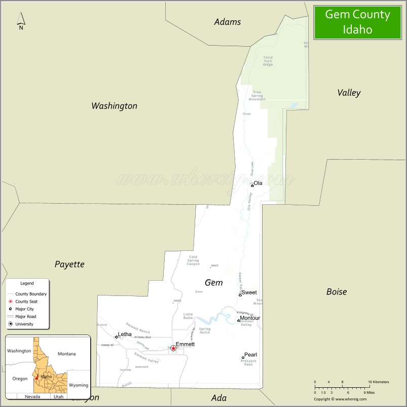
About Gem County Map, Idaho: The map showing the county boundary, county seat, major cities, highways, water bodies and neighbouring counties.
Most Viewed Links
| Idaho Map | Idaho County Map | Idaho Cities Map |
| Idaho Zipcodes | Airports in Idaho | Where is Idaho |
| Idaho Area Codes | Idaho Blank Map | Idaho River Map |
| Idaho Physical Map | Idaho Road Map |
Map of Gem County, Idaho
Gem County is a county located in the U.S. state of Idaho. It's county seat is Emmett. As per 2020 census, the population of Gem County is 19792 people and population density is square miles. According to the United States Census Bureau, the county has a total area of 563 sq mi (1,458 km2). Gem County was established on 1915.
Gem County Facts
| Continent | North America |
| Country | United States |
| State | Idaho |
| County Seat | Emmett |
| Largest City/Town | Emmett |
| Established | 1915 |
| Total Area | 566 sq mi (1,466 sq km) |
| Land Area | 561 sq mi (1,453 sq km) |
| Water Area | 5 sq mi (13 sq km) |
| Population | 19,123 (Census 2020) |
| Population Density | 34 people per sq mi |
| Time Zone | Mountain Time Zone (MT) |
| Major Highways | Idaho State Highway 16, Idaho State Highway 52, Idaho State Highway 55 |
| Major Rivers | Payette River, Squaw Creek |
| Neighboring Counties | Washington County, Adams County, Valley County, Boise County, Ada County, Canyon County, Payette County |
| Famous For | Fruit orchards, Emmett Cherry Festival, Payette River recreation, and scenic rural valleys |
| Top Attractions | Black Canyon Reservoir, Emmett Cherry Festival, Payette River, Firebird Raceway nearby area, Boise National Forest nearby region |
| Official Website | Official Website |
About Gem County, Idaho
Gem County is located in southwestern Idaho and was established in 1915. The county seat and largest city is Emmett. Gem County is part of the Boise metropolitan area and is known for orchards, agriculture, river recreation, rural scenery, and outdoor activities along the Payette River valley. :contentReference[oaicite:0]{index=0}
Cities and Communities in Gem County, Idaho
| City/Town | Population | Latitude & Longitude |
|---|---|---|
| Emmett (county seat) | 7,500+ | 43.8735°N, 116.4993°W |
| Letha | 700+ | 43.8946°N, 116.6237°W |
| Sweet | Rural Community | 44.0132°N, 116.3254°W |
| Ola | Mountain Community | 44.2196°N, 116.2912°W |
| Montour | Scenic Area | 43.9238°N, 116.5954°W |
| Brick | Historic Community | 43.8877°N, 116.4541°W |
| Freezeout Hill Area | Mountain Region | 44.0467°N, 116.4831°W |
| Payette River Valley Area | Agricultural Region | 43.8661°N, 116.5062°W |
Best Golf Courses in Gem County, Idaho
| Golf Course | Location | Latitude & Longitude |
|---|---|---|
| Gem County Golf Course | Emmett | 43.8722°N, 116.4885°W |
| Scotch Pines Golf Course | Nearby Payette | 44.0718°N, 116.9158°W |
| Falcon Crest Golf Club | Nearby Kuna | 43.4870°N, 116.3977°W |
| BanBury Golf Course | Nearby Eagle | 43.6944°N, 116.3545°W |
What are Major Roads and Highways in Gem County
Major highways connect Gem County with Boise, western Idaho agricultural communities, and mountain recreation destinations throughout the Payette River region. :contentReference[oaicite:1]{index=1}
- Idaho State Highway 16 - primary route connecting Emmett with the Boise area
- Idaho State Highway 52 - scenic highway through agricultural valleys and river communities
- Idaho State Highway 55 - major route toward central Idaho recreation areas
- Payette River Scenic Roads - local routes serving recreation and orchard regions
Neighboring Counties of Gem County
- Washington County (northwest)
- Adams County (north)
- Valley County (northeast)
- Boise County (east)
- Ada County (south)
- Canyon County (southwest)
- Payette County (west)
What are Top Attractions in Gem County, Idaho
The county offers orchards, river recreation, small-town festivals, hiking, fishing, scenic drives, and outdoor activities across southwestern Idaho valleys and foothills.
| Main Sight Name | City | Famous For |
|---|---|---|
| Black Canyon Reservoir | Emmett Area | Boating, fishing, and camping recreation |
| Emmett Cherry Festival | Emmett | Annual community festival celebrating local orchards |
| Payette River | Countywide | Fishing, rafting, and scenic river recreation |
| Firebird Raceway Nearby Area | Southern Region | Motorsports and racing events |
| Boise National Forest Nearby Region | Eastern County Area | Camping, hiking, and wildlife recreation |
| Freezeout Hill Scenic Area | Northern Region | Mountain views and photography |
| Gem Island Sports Complex | Emmett | Sports events and family recreation |
| Historic Downtown Emmett | Emmett | Local shops, dining, and historic buildings |
| Squaw Creek Recreation Areas | Countywide | Fishing and rural scenery |
| Orchard Scenic Drives | Countywide | Fruit orchards and seasonal blossom views |
Distance from Gem County to Nearby Cities
The following distances are measured by road (driving).
- Emmett to Boise, Idaho - 31 mi (50 km)
- Emmett to Nampa, Idaho - 34 mi (55 km)
- Emmett to Caldwell, Idaho - 22 mi (35 km)
- Emmett to McCall, Idaho - 83 mi (134 km)
- Emmett to Twin Falls, Idaho - 155 mi (249 km)
- Emmett to Idaho Falls, Idaho - 295 mi (475 km)
- Emmett to Salt Lake City, Utah - 387 mi (623 km)
- Emmett to Spokane, Washington - 305 mi (491 km)
- Emmett to Portland, Oregon - 402 mi (647 km)
- Emmett to Seattle, Washington - 477 mi (768 km)
- Emmett to Reno, Nevada - 389 mi (626 km)
- Emmett to Denver, Colorado - 860 mi (1,384 km)
References
- Gem County Official Website
- Gem County, Idaho - Wikipedia
- U.S. Census Bureau QuickFacts
- Visit Idaho Tourism
- Emmett, Idaho
- Ada County Map
- Adams County Map
- Bannock County Map
- Bear Lake County Map
- Benewah County Map
- Bingham County Map
- Blaine County Map
- Boise County Map
- Bonner County Map
- Bonneville County Map
- Boundary County Map
- Butte County Map
- Camas County Map
- Canyon County Map
- Caribou County Map
- Cassia County Map
- Clark County Map
- Clearwater County Map
- Custer County Map
- Elmore County Map
- Franklin County Map
- Fremont County Map
- Gem County Map
- Gooding County Map
- Idaho County Map
- Jefferson County Map
- Jerome County Map
- Kootenai County Map
- Latah County Map
- Lemhi County Map
- Lewis County Map
- Lincoln County Map
- Madison County Map
- Minidoka County Map
- Nez Perce County Map
- Oneida County Map
- Owyhee County Map
- Payette County Map
- Power County Map
- Shoshone County Map
- Teton County Map
- Twin Falls County Map
- Valley County Map
- Washington County Map
- Alabama Counties
- Alaska boroughs
- Arizona Counties
- Arkansas Counties
- California County Map
- Colorado Counties
- Connecticut Counties
- Delaware Counties
- Florida County Map
- Georgia County Map
- Hawaii Counties
- Idaho Counties
- Illinois Counties
- Indiana Counties
- Iowa Counties
- Kansas Counties
- Kentucky Counties
- Louisiana Counties
- Maine Counties
- Maryland Counties
- Massachusetts Counties
- Michigan County Map
- Minnesota Counties
- Mississippi Counties
- Missouri Counties
- Montana Counties
- Nebraska Counties
- Nevada Counties
- New York Counties
- New Hampshire Counties
- New Jersey Counties
- New Mexico Counties
- North Carolina Counties
- North Dakota Counties
- Ohio County Map
- Oklahoma Counties
- Oregon Counties
- Pennsylvania Counties
- Rhode Island Counties
- South Carolina Counties
- South Dakota Counties
- Map of Tennessee
- Texas County Map
- Utah Counties
- Vermont Counties
- Virginia Counties
- Washington Counties
- West Virginia Counties
- Wisconsin Counties
- Wyoming Counties