Map of Washington County - Washington County is a county located in the U.S. state of Idaho. Washington County Map showing cities, highways, important places and water bodies. Get Where is Washington County located in the map, major cities in Washington county, population, areas, and places of interest.
Washington County Map, Idaho
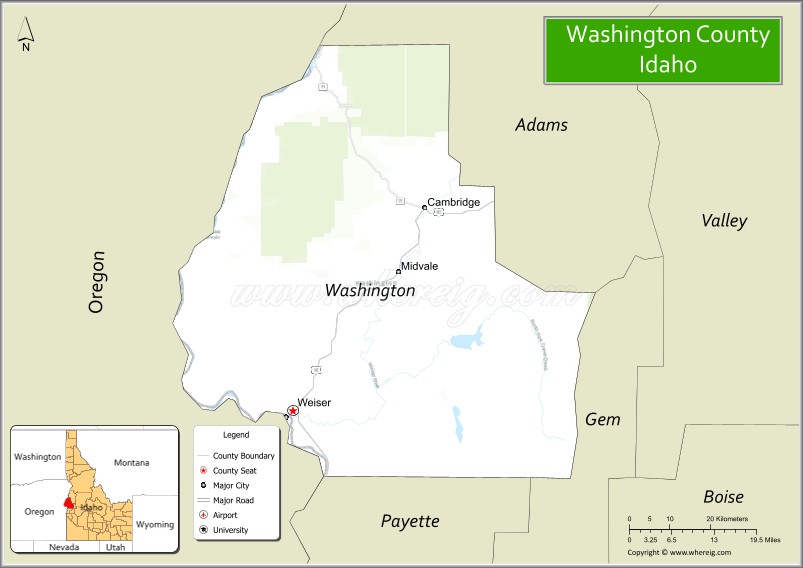
About Washington County Map, Idaho: The map showing the county boundary, county seat, major cities, highways, water bodies and neighbouring counties.
Most Viewed Links
| Idaho Map | Idaho County Map | Idaho Cities Map |
| Idaho Zipcodes | Airports in Idaho | Where is Idaho |
| Idaho Area Codes | Idaho Blank Map | Idaho River Map |
| Idaho Physical Map | Idaho Road Map |
Map of Washington County, Idaho
Washington County is a county located in the U.S. state of Idaho. It's county seat is Weiser. As per 2020 census, the population of Washington County is 10898 people and population density is square miles. According to the United States Census Bureau, the county has a total area of 1,456 sq mi (3,771 km2). Washington County was established on 1879.
Washington County Facts
| Continent | North America |
| Country | United States |
| State | Idaho |
| County Seat | Weiser |
| Largest City/Town | Weiser |
| Established | 1879 |
| Total Area | 1,478 sq mi (3,828 sq km) |
| Land Area | 1,453 sq mi (3,763 sq km) |
| Water Area | 25 sq mi (65 sq km) |
| Population | 10,613 (Census 2020) |
| Population Density | 7.3 people per sq mi |
| Time Zone | Mountain Time Zone (MT) |
| Major Highways | U.S. Route 95, U.S. Route 30, Idaho State Highway 71 |
| Major Rivers | Snake River, Weiser River, Little Weiser River |
| Neighboring Counties | Adams County, Gem County, Payette County, Malheur County (Oregon), Baker County (Oregon) |
| Famous For | National Oldtime Fiddlers' Contest, agriculture, Hells Canyon gateway access, and river recreation |
| Top Attractions | Hells Canyon nearby area, Weiser River Trail, National Oldtime Fiddlers' Contest, Mann Creek Reservoir, Historic Downtown Weiser |
| Official Website | Official Website |
About Washington County, Idaho
Washington County is located in western Idaho along the Oregon border and was established in 1879. The county seat and largest city is Weiser. Washington County is known for agriculture, scenic river valleys, western heritage, outdoor recreation, and hosting the famous National Oldtime Fiddlers' Contest each year in Weiser. ([en.wikipedia.org](https://en.wikipedia.org/wiki/Washington_County,_Idaho?utm_source=chatgpt.com))
Cities and Communities in Washington County, Idaho
| City/Town | Population | Latitude & Longitude |
|---|---|---|
| Weiser (county seat) | 5,000+ | 44.2491°N, 116.9693°W |
| Midvale | 200+ | 44.4710°N, 116.7340°W |
| Cambridge | 300+ | 44.5727°N, 116.6765°W |
| Huntington Nearby Area | Regional Community | 44.3510°N, 117.2660°W |
| Mesa | Small Community | 44.6224°N, 116.4376°W |
| Indian Valley | Mountain Valley Community | 44.5548°N, 116.3965°W |
| Crane Creek Area | Scenic Region | 44.2942°N, 116.6743°W |
| Weiser River Valley | Agricultural Region | 44.2445°N, 116.9828°W |
Best Golf Courses in Washington County, Idaho
| Golf Course | Location | Latitude & Longitude |
|---|---|---|
| Rolling Hills Golf Course | Weiser | 44.2565°N, 116.9660°W |
| Scotch Pines Golf Course | Nearby Payette | 44.0718°N, 116.9158°W |
| Purple Sage Golf Course | Nearby Caldwell | 43.6628°N, 116.6767°W |
| Quail Ridge Golf Course | Nearby Baker City, Oregon | 44.7782°N, 117.8315°W |
What are Major Roads and Highways in Washington County
Major highways connect Washington County with Oregon, the Treasure Valley, and scenic recreation regions in western Idaho and eastern Oregon. ([en.wikipedia.org](https://en.wikipedia.org/wiki/Washington_County,_Idaho?utm_source=chatgpt.com))
- U.S. Route 95 - major north-south transportation corridor through western Idaho
- U.S. Route 30 - regional highway connecting Weiser with nearby communities
- Idaho State Highway 71 - scenic route toward Hells Canyon and Brownlee Reservoir
- Weiser River Scenic Routes - roadways through river valleys and agricultural areas
Neighboring Counties of Washington County
- Adams County (north)
- Gem County (south)
- Payette County (southwest)
- Malheur County, Oregon (west)
- Baker County, Oregon (northwest)
What are Top Attractions in Washington County, Idaho
The county offers river recreation, western heritage festivals, hiking, fishing, scenic drives, and outdoor adventures throughout western Idaho and nearby canyon regions.
| Main Sight Name | City | Famous For |
|---|---|---|
| Hells Canyon Nearby Area | Western Region | Deep canyon scenery and outdoor recreation |
| Weiser River Trail | Countywide | Rail-trail biking, hiking, and horseback riding |
| National Oldtime Fiddlers' Contest | Weiser | Annual music festival and cultural event |
| Mann Creek Reservoir | Northwestern County | Fishing, boating, and camping |
| Historic Downtown Weiser | Weiser | Historic architecture and local shops |
| Crane Creek Reservoir | Crane Creek Area | Camping and fishing recreation |
| Weiser River | Countywide | Fishing and scenic river landscapes |
| Indian Valley Scenic Areas | Indian Valley | Mountain views and wildlife viewing |
| Cambridge Historic District | Cambridge | Historic western small-town atmosphere |
| Brownlee Reservoir Nearby Area | Western Border Region | Boating and canyon recreation |
Distance from Washington County to Nearby Cities
The following distances are measured by road (driving).
- Weiser to Boise, Idaho - 72 mi (116 km)
- Weiser to Payette, Idaho - 14 mi (23 km)
- Weiser to Ontario, Oregon - 11 mi (18 km)
- Weiser to Baker City, Oregon - 73 mi (117 km)
- Weiser to McCall, Idaho - 82 mi (132 km)
- Weiser to Twin Falls, Idaho - 191 mi (307 km)
- Weiser to Spokane, Washington - 322 mi (518 km)
- Weiser to Portland, Oregon - 345 mi (555 km)
- Weiser to Salt Lake City, Utah - 408 mi (657 km)
- Weiser to Seattle, Washington - 492 mi (792 km)
- Weiser to Reno, Nevada - 406 mi (653 km)
- Weiser to Yellowstone National Park - 392 mi (631 km)
References
- Washington County Official Website
- Washington County, Idaho - Wikipedia
- U.S. Census Bureau QuickFacts
- Visit Idaho Tourism
- Weiser River Trail
- Ada County Map
- Adams County Map
- Bannock County Map
- Bear Lake County Map
- Benewah County Map
- Bingham County Map
- Blaine County Map
- Boise County Map
- Bonner County Map
- Bonneville County Map
- Boundary County Map
- Butte County Map
- Camas County Map
- Canyon County Map
- Caribou County Map
- Cassia County Map
- Clark County Map
- Clearwater County Map
- Custer County Map
- Elmore County Map
- Franklin County Map
- Fremont County Map
- Gem County Map
- Gooding County Map
- Idaho County Map
- Jefferson County Map
- Jerome County Map
- Kootenai County Map
- Latah County Map
- Lemhi County Map
- Lewis County Map
- Lincoln County Map
- Madison County Map
- Minidoka County Map
- Nez Perce County Map
- Oneida County Map
- Owyhee County Map
- Payette County Map
- Power County Map
- Shoshone County Map
- Teton County Map
- Twin Falls County Map
- Valley County Map
- Washington County Map
- Alabama Counties
- Alaska boroughs
- Arizona Counties
- Arkansas Counties
- California County Map
- Colorado Counties
- Connecticut Counties
- Delaware Counties
- Florida County Map
- Georgia County Map
- Hawaii Counties
- Idaho Counties
- Illinois Counties
- Indiana Counties
- Iowa Counties
- Kansas Counties
- Kentucky Counties
- Louisiana Counties
- Maine Counties
- Maryland Counties
- Massachusetts Counties
- Michigan County Map
- Minnesota Counties
- Mississippi Counties
- Missouri Counties
- Montana Counties
- Nebraska Counties
- Nevada Counties
- New York Counties
- New Hampshire Counties
- New Jersey Counties
- New Mexico Counties
- North Carolina Counties
- North Dakota Counties
- Ohio County Map
- Oklahoma Counties
- Oregon Counties
- Pennsylvania Counties
- Rhode Island Counties
- South Carolina Counties
- South Dakota Counties
- Map of Tennessee
- Texas County Map
- Utah Counties
- Vermont Counties
- Virginia Counties
- Washington Counties
- West Virginia Counties
- Wisconsin Counties
- Wyoming Counties