Map of Lincoln County - Lincoln County is a county located in the U.S. state of Idaho. Lincoln County Map showing cities, highways, important places and water bodies. Get Where is Lincoln County located in the map, major cities in Lincoln county, population, areas, and places of interest.
Lincoln County Map, Idaho
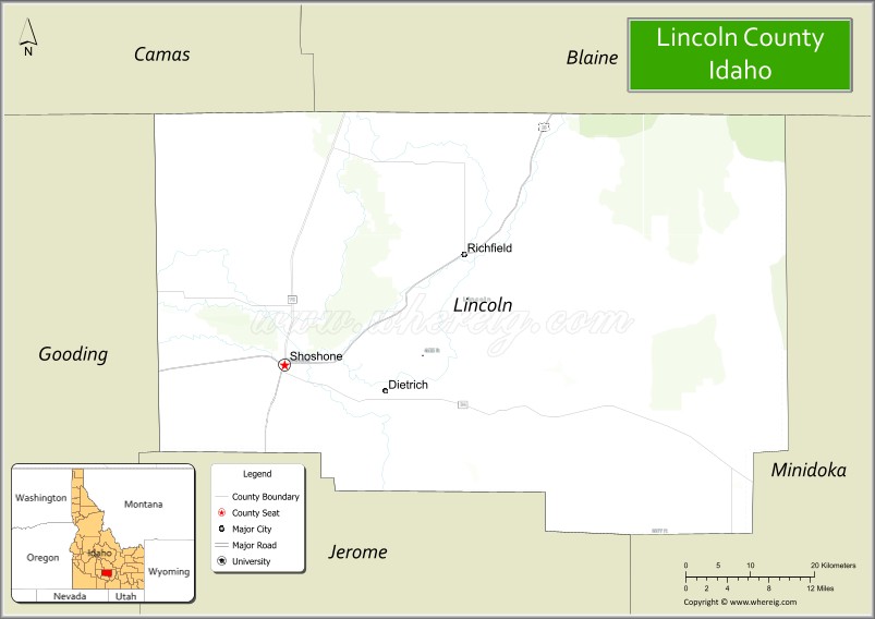
About Lincoln County Map, Idaho: The map showing the county boundary, county seat, major cities, highways, water bodies and neighbouring counties.
Most Viewed Links
| Idaho Map | Idaho County Map | Idaho Cities Map |
| Idaho Zipcodes | Airports in Idaho | Where is Idaho |
| Idaho Area Codes | Idaho Blank Map | Idaho River Map |
| Idaho Physical Map | Idaho Road Map |
Map of Lincoln County, Idaho
Lincoln County is a county located in the U.S. state of Idaho. It's county seat is Shoshone. As per 2020 census, the population of Lincoln County is 5282 people and population density is square miles. According to the United States Census Bureau, the county has a total area of 1,206 sq mi (3,124 km2). Lincoln County was established on 1895.
Lincoln County Facts
| Continent | North America |
| Country | United States |
| State | Idaho |
| County Seat | Shoshone |
| Largest City/Town | Shoshone |
| Established | 1895 |
| Total Area | 1,206 sq mi (3,124 sq km) |
| Land Area | 1,201 sq mi (3,111 sq km) |
| Water Area | 5 sq mi (13 sq km) |
| Population | 5,127 (Census 2020) |
| Population Density | 4.3 people per sq mi |
| Time Zone | Mountain Time Zone (MT) |
| Major Highways | U.S. Route 26, U.S. Route 93, Idaho State Highway 24, Idaho State Highway 75 |
| Major Rivers | Big Wood River, Little Wood River, Snake River nearby area |
| Neighboring Counties | Camas County, Blaine County, Minidoka County, Jerome County, Gooding County |
| Famous For | Craters of the Moon nearby area, desert landscapes, agriculture, and scenic volcanic plains |
| Top Attractions | Craters of the Moon National Monument nearby area, Shoshone Ice Caves, Black Magic Canyon, Little Wood River, Richfield Historic Area |
| Official Website | Official Website |
About Lincoln County, Idaho
Lincoln County is located in south-central Idaho and was established in 1895. The county seat and largest city is Shoshone. Lincoln County is known for volcanic landscapes, open desert scenery, agricultural communities, and nearby access to Craters of the Moon National Monument and Preserve. :contentReference[oaicite:0]{index=0}
Cities and Communities in Lincoln County, Idaho
| City/Town | Population | Latitude & Longitude |
|---|---|---|
| Shoshone (county seat) | 1,500+ | 42.9360°N, 114.4059°W |
| Richfield | 500+ | 43.0513°N, 114.1570°W |
| Dietrich | 300+ | 42.9152°N, 114.2695°W |
| Kimama | Rural Community | 43.3391°N, 114.3653°W |
| Hidden Valley Area | Scenic Region | 42.7751°N, 114.2738°W |
| Little Wood River Area | Agricultural Region | 43.0288°N, 114.3307°W |
| Shoshone Lava Fields Area | Volcanic Region | 43.0112°N, 114.3925°W |
| Richfield Canal Area | Farming District | 43.0542°N, 114.1758°W |
Best Golf Courses in Lincoln County, Idaho
| Golf Course | Location | Latitude & Longitude |
|---|---|---|
| Shoshone Golf Club | Shoshone | 42.9369°N, 114.4124°W |
| Gooding Golf Club | Nearby Gooding | 42.9391°N, 114.7084°W |
| Jerome Country Club | Nearby Jerome | 42.7172°N, 114.5255°W |
| Blue Lakes Country Club | Nearby Twin Falls | 42.5768°N, 114.4695°W |
What are Major Roads and Highways in Lincoln County
Major highways connect Lincoln County with southern Idaho agricultural regions, volcanic landscapes, and recreation destinations across the Snake River Plain. :contentReference[oaicite:1]{index=1}
- U.S. Route 26 - major east-west highway through Shoshone
- U.S. Route 93 - regional north-south transportation corridor
- Idaho State Highway 24 - scenic route toward Craters of the Moon
- Idaho State Highway 75 - roadway connecting nearby mountain and recreation regions
Neighboring Counties of Lincoln County
- Camas County (northwest)
- Blaine County (north)
- Minidoka County (east)
- Jerome County (south)
- Gooding County (west)
What are Top Attractions in Lincoln County, Idaho
The county offers volcanic scenery, caves, desert landscapes, fishing, camping, scenic drives, and outdoor recreation throughout south-central Idaho. :contentReference[oaicite:2]{index=2}
| Main Sight Name | City | Famous For |
|---|---|---|
| Craters of the Moon National Monument Nearby Area | Northern Region | Volcanic lava fields and unique geological formations |
| Shoshone Ice Caves | Shoshone | Underground lava tube ice caves |
| Black Magic Canyon | Richfield Area | Dramatic lava-carved canyon scenery |
| Little Wood River | Countywide | Fishing and rural recreation |
| Richfield Historic Area | Richfield | Historic farming community and local heritage |
| Shoshone Bird Museum | Shoshone | Wildlife and bird exhibit collections |
| Big Wood River Scenic Areas | Northern County | Fishing and desert landscapes |
| Volcanic Lava Fields | Countywide | Photography and geological exploration |
| Desert Scenic Drives | Countywide | Open landscapes and volcanic plains |
| Camas Prairie Nearby Area | Northern Region | Wildlife viewing and rural scenery |
Distance from Lincoln County to Nearby Cities
The following distances are measured by road (driving).
- Shoshone to Twin Falls, Idaho - 33 mi (53 km)
- Shoshone to Jerome, Idaho - 28 mi (45 km)
- Shoshone to Gooding, Idaho - 32 mi (51 km)
- Shoshone to Sun Valley, Idaho - 72 mi (116 km)
- Shoshone to Boise, Idaho - 120 mi (193 km)
- Shoshone to Pocatello, Idaho - 122 mi (196 km)
- Shoshone to Idaho Falls, Idaho - 164 mi (264 km)
- Shoshone to Salt Lake City, Utah - 263 mi (423 km)
- Shoshone to Reno, Nevada - 411 mi (661 km)
- Shoshone to Spokane, Washington - 450 mi (724 km)
- Shoshone to Portland, Oregon - 485 mi (780 km)
- Shoshone to Denver, Colorado - 713 mi (1,147 km)
References
- Lincoln County Official Website
- Lincoln County, Idaho - Wikipedia
- U.S. Census Bureau QuickFacts
- Craters of the Moon National Monument
- Visit Idaho Tourism
- Ada County Map
- Adams County Map
- Bannock County Map
- Bear Lake County Map
- Benewah County Map
- Bingham County Map
- Blaine County Map
- Boise County Map
- Bonner County Map
- Bonneville County Map
- Boundary County Map
- Butte County Map
- Camas County Map
- Canyon County Map
- Caribou County Map
- Cassia County Map
- Clark County Map
- Clearwater County Map
- Custer County Map
- Elmore County Map
- Franklin County Map
- Fremont County Map
- Gem County Map
- Gooding County Map
- Idaho County Map
- Jefferson County Map
- Jerome County Map
- Kootenai County Map
- Latah County Map
- Lemhi County Map
- Lewis County Map
- Lincoln County Map
- Madison County Map
- Minidoka County Map
- Nez Perce County Map
- Oneida County Map
- Owyhee County Map
- Payette County Map
- Power County Map
- Shoshone County Map
- Teton County Map
- Twin Falls County Map
- Valley County Map
- Washington County Map
- Alabama Counties
- Alaska boroughs
- Arizona Counties
- Arkansas Counties
- California County Map
- Colorado Counties
- Connecticut Counties
- Delaware Counties
- Florida County Map
- Georgia County Map
- Hawaii Counties
- Idaho Counties
- Illinois Counties
- Indiana Counties
- Iowa Counties
- Kansas Counties
- Kentucky Counties
- Louisiana Counties
- Maine Counties
- Maryland Counties
- Massachusetts Counties
- Michigan County Map
- Minnesota Counties
- Mississippi Counties
- Missouri Counties
- Montana Counties
- Nebraska Counties
- Nevada Counties
- New York Counties
- New Hampshire Counties
- New Jersey Counties
- New Mexico Counties
- North Carolina Counties
- North Dakota Counties
- Ohio County Map
- Oklahoma Counties
- Oregon Counties
- Pennsylvania Counties
- Rhode Island Counties
- South Carolina Counties
- South Dakota Counties
- Map of Tennessee
- Texas County Map
- Utah Counties
- Vermont Counties
- Virginia Counties
- Washington Counties
- West Virginia Counties
- Wisconsin Counties
- Wyoming Counties