Map of Butte County - Butte County is a county located in the U.S. state of Idaho. Butte County Map showing cities, highways, important places and water bodies. Get Where is Butte County located in the map, major cities in Butte county, population, areas, and places of interest.
Butte County Map, Idaho
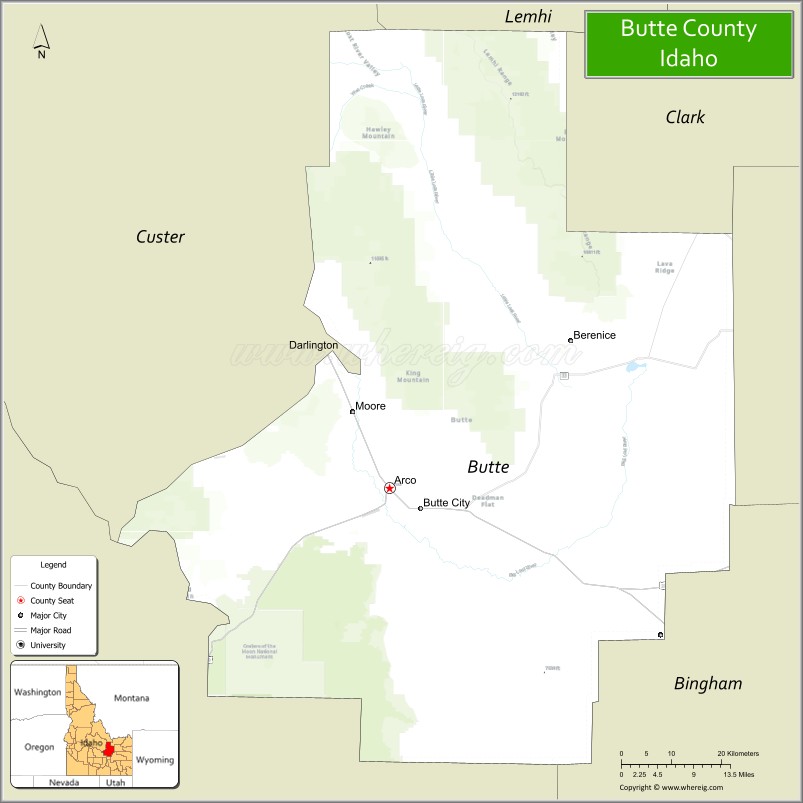
About Butte County Map, Idaho: The map showing the county boundary, county seat, major cities, highways, water bodies and neighbouring counties.
Most Viewed Links
| Idaho Map | Idaho County Map | Idaho Cities Map |
| Idaho Zipcodes | Airports in Idaho | Where is Idaho |
| Idaho Area Codes | Idaho Blank Map | Idaho River Map |
| Idaho Physical Map | Idaho Road Map |
Map of Butte County, Idaho
Butte County is a county located in the U.S. state of Idaho. It's county seat is Arco. As per 2020 census, the population of Butte County is 2654 people and population density is square miles. According to the United States Census Bureau, the county has a total area of 2,233 sq mi (5,783 km2). Butte County was established on 1917.
Butte County Facts
| Continent | North America |
| Country | United States |
| State | Idaho |
| County Seat | Arco |
| Largest City/Town | Arco |
| Established | 1917 |
| Total Area | 2,234 sq mi (5,786 sq km) |
| Land Area | 2,232 sq mi (5,780 sq km) |
| Water Area | 2 sq mi (5 sq km) |
| Population | 2,806 (Census 2020) |
| Population Density | 1.3 people per sq mi |
| Time Zone | Mountain Time Zone (MT) |
| Major Highways | U.S. Route 20, U.S. Route 26, U.S. Route 93, Idaho State Highway 22 |
| Major Rivers | Big Lost River, Little Lost River |
| Neighboring Counties | Custer County, Clark County, Jefferson County, Bingham County, Blaine County |
| Famous For | Craters of the Moon, nuclear energy history, high desert landscapes, and mountain recreation |
| Top Attractions | Craters of the Moon National Monument, EBR-I Atomic Museum, Lost River Range, Big Southern Butte, Arco Number Hill |
| Official Website | Official Website |
About Butte County, Idaho
Butte County is located in central-eastern Idaho and was established in 1917. The county seat and largest city is Arco, which became the first city in the world powered by nuclear energy in 1955. Butte County is known for volcanic landscapes, wide-open high desert scenery, scientific history, and outdoor recreation near Craters of the Moon National Monument and the Lost River Range. ([en.wikipedia.org](https://en.wikipedia.org/wiki/Butte_County,_Idaho?utm_source=chatgpt.com))
Cities and Communities in Butte County, Idaho
| City/Town | Population | Latitude & Longitude |
|---|---|---|
| Arco (county seat) | 1,000+ | 43.6366°N, 113.3003°W |
| Moore | 200+ | 43.6424°N, 113.3650°W |
| Howe | Rural Community | 43.7866°N, 113.0012°W |
| Darlington | Historic Area | 43.4962°N, 113.3568°W |
| Leslie | Mountain Community | 43.7310°N, 113.4509°W |
| Blue Dome Area | Scenic Region | 43.5794°N, 113.5571°W |
| Lost River Valley Area | Agricultural Region | 43.7407°N, 113.4525°W |
| Atomic City Nearby Area | Historic Community | 43.4449°N, 112.8120°W |
Best Golf Courses in Butte County, Idaho
| Golf Course | Location | Latitude & Longitude |
|---|---|---|
| Lost River Valley Golf Course | Arco | 43.6328°N, 113.3015°W |
| Cedar Park Golf Course | Nearby Ririe | 43.6469°N, 111.7728°W |
| Jefferson Hills Golf Course | Nearby Rigby | 43.6851°N, 111.9207°W |
| Pinecrest Golf Course | Nearby Idaho Falls | 43.4820°N, 112.0394°W |
What are Major Roads and Highways in Butte County
Major highways connect Butte County with central Idaho, eastern Idaho communities, and scenic recreation areas across the Snake River Plain and Lost River Valley.
- U.S. Route 20 - major east-west transportation corridor through Arco
- U.S. Route 26 - regional highway connecting eastern Idaho communities
- U.S. Route 93 - scenic route through mountain and desert landscapes
- Idaho State Highway 22 - roadway serving local agricultural and recreation areas
Neighboring Counties of Butte County
- Custer County (north)
- Clark County (east)
- Jefferson County (east)
- Bingham County (south)
- Blaine County (west)
What are Top Attractions in Butte County, Idaho
The county offers volcanic monuments, mountain scenery, nuclear history attractions, hiking, camping, and wide-open outdoor recreation landscapes. ([nps.gov](https://www.nps.gov/crmo/index.htm?utm_source=chatgpt.com))
| Main Sight Name | City | Famous For |
|---|---|---|
| Craters of the Moon National Monument | Southern Butte County Area | Volcanic lava fields, caves, and hiking trails |
| EBR-I Atomic Museum | Arco Area | First nuclear-powered electricity generation site |
| Lost River Range | Countywide | Mountain hiking, camping, and scenic views |
| Big Southern Butte | Southern Region | Volcanic landmark and panoramic desert scenery |
| Arco Number Hill | Arco | Historic hill displaying graduating class numbers |
| Big Lost River | Countywide | Fishing and scenic valley landscapes |
| INL Nearby Area | Eastern Region | Idaho National Laboratory scientific heritage |
| Blue Dome Volcanic Area | Western County Area | Unique geological formations and photography |
| Mountain Scenic Drives | Countywide | High desert and alpine scenery |
| Camping and Wilderness Areas | Countywide | Outdoor recreation and stargazing |
Distance from Butte County to Nearby Cities
The following distances are measured by road (driving).
- Arco to Idaho Falls, Idaho - 68 mi (109 km)
- Arco to Pocatello, Idaho - 115 mi (185 km)
- Arco to Twin Falls, Idaho - 117 mi (188 km)
- Arco to Sun Valley, Idaho - 86 mi (138 km)
- Arco to Boise, Idaho - 196 mi (315 km)
- Arco to Jackson, Wyoming - 158 mi (254 km)
- Arco to Salt Lake City, Utah - 275 mi (443 km)
- Arco to Yellowstone National Park - 170 mi (274 km)
- Arco to Reno, Nevada - 465 mi (748 km)
- Arco to Denver, Colorado - 625 mi (1,006 km)
- Arco to Spokane, Washington - 473 mi (761 km)
- Arco to Seattle, Washington - 628 mi (1,011 km)
References
- Butte County Official Website
- Butte County, Idaho - Wikipedia
- U.S. Census Bureau QuickFacts
- Craters of the Moon National Monument
- Visit Idaho Tourism
- Ada County Map
- Adams County Map
- Bannock County Map
- Bear Lake County Map
- Benewah County Map
- Bingham County Map
- Blaine County Map
- Boise County Map
- Bonner County Map
- Bonneville County Map
- Boundary County Map
- Butte County Map
- Camas County Map
- Canyon County Map
- Caribou County Map
- Cassia County Map
- Clark County Map
- Clearwater County Map
- Custer County Map
- Elmore County Map
- Franklin County Map
- Fremont County Map
- Gem County Map
- Gooding County Map
- Idaho County Map
- Jefferson County Map
- Jerome County Map
- Kootenai County Map
- Latah County Map
- Lemhi County Map
- Lewis County Map
- Lincoln County Map
- Madison County Map
- Minidoka County Map
- Nez Perce County Map
- Oneida County Map
- Owyhee County Map
- Payette County Map
- Power County Map
- Shoshone County Map
- Teton County Map
- Twin Falls County Map
- Valley County Map
- Washington County Map
- Alabama Counties
- Alaska boroughs
- Arizona Counties
- Arkansas Counties
- California County Map
- Colorado Counties
- Connecticut Counties
- Delaware Counties
- Florida County Map
- Georgia County Map
- Hawaii Counties
- Idaho Counties
- Illinois Counties
- Indiana Counties
- Iowa Counties
- Kansas Counties
- Kentucky Counties
- Louisiana Counties
- Maine Counties
- Maryland Counties
- Massachusetts Counties
- Michigan County Map
- Minnesota Counties
- Mississippi Counties
- Missouri Counties
- Montana Counties
- Nebraska Counties
- Nevada Counties
- New York Counties
- New Hampshire Counties
- New Jersey Counties
- New Mexico Counties
- North Carolina Counties
- North Dakota Counties
- Ohio County Map
- Oklahoma Counties
- Oregon Counties
- Pennsylvania Counties
- Rhode Island Counties
- South Carolina Counties
- South Dakota Counties
- Map of Tennessee
- Texas County Map
- Utah Counties
- Vermont Counties
- Virginia Counties
- Washington Counties
- West Virginia Counties
- Wisconsin Counties
- Wyoming Counties