Map of Bonner County - Bonner County is a county located in the U.S. state of Idaho. Bonner County Map showing cities, highways, important places and water bodies. Get Where is Bonner County located in the map, major cities in Bonner county, population, areas, and places of interest.
Bonner County Map, Idaho
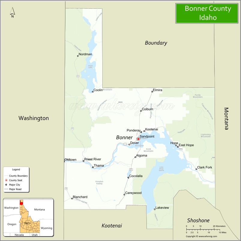
About Bonner County Map, Idaho: The map showing the county boundary, county seat, major cities, highways, water bodies and neighbouring counties.
Most Viewed Links
| Idaho Map | Idaho County Map | Idaho Cities Map |
| Idaho Zipcodes | Airports in Idaho | Where is Idaho |
| Idaho Area Codes | Idaho Blank Map | Idaho River Map |
| Idaho Physical Map | Idaho Road Map |
Map of Bonner County, Idaho
Bonner County is a county located in the U.S. state of Idaho. It's county seat is Sandpoint. As per 2020 census, the population of Bonner County is 49491 people and population density is square miles. According to the United States Census Bureau, the county has a total area of 1,738 sq mi (4,501 km2). Bonner County was established on 1907.
Bonner County Facts
| Continent | North America |
| Country | United States |
| State | Idaho |
| County Seat | Sandpoint |
| Largest City/Town | Sandpoint |
| Established | 1907 |
| Total Area | 1,919 sq mi (4,970 sq km) |
| Land Area | 1,738 sq mi (4,501 sq km) |
| Water Area | 181 sq mi (469 sq km) |
| Population | 47,110 (Census 2020) |
| Population Density | 27 people per sq mi |
| Time Zone | Pacific Time Zone (PT) |
| Major Highways | U.S. Route 95, U.S. Route 2, Idaho State Highway 200 |
| Major Lakes/Rivers | Lake Pend Oreille, Pend Oreille River, Priest River |
| Neighboring Counties | Boundary County, Kootenai County, Shoshone County, Lincoln County (Montana) |
| Famous For | Lake Pend Oreille, Schweitzer Mountain Resort, outdoor recreation, and scenic Idaho Panhandle landscapes |
| Top Attractions | Schweitzer Mountain Resort, Lake Pend Oreille, Farragut State Park nearby area, Sandpoint City Beach, Pend Oreille Scenic Byway |
| Official Website | Official Website |
About Bonner County, Idaho
Bonner County is located in the Idaho Panhandle region of northern Idaho and was established in 1907. The county seat and largest city is Sandpoint, situated along the shores of Lake Pend Oreille. Bonner County is known for mountain scenery, lake recreation, skiing, forests, wildlife, and year-round outdoor tourism in one of Idaho’s most scenic regions. ([en.wikipedia.org](https://en.wikipedia.org/wiki/Bonner_County,_Idaho?utm_source=chatgpt.com))
Cities and Communities in Bonner County, Idaho
| City/Town | Population | Latitude & Longitude |
|---|---|---|
| Sandpoint (county seat) | 9,000+ | 48.2766°N, 116.5532°W |
| Priest River | 2,000+ | 48.1813°N, 116.9094°W |
| Oldtown | 200+ | 48.1800°N, 117.0385°W |
| Dover | 700+ | 48.2510°N, 116.6205°W |
| Kootenai | 1,000+ | 48.3127°N, 116.5152°W |
| Hope | Lakeside Community | 48.2460°N, 116.3077°W |
| Clark Fork | 500+ | 48.1457°N, 116.1785°W |
| Sagle | Mountain Community | 48.1897°N, 116.5474°W |
Best Golf Courses in Bonner County, Idaho
| Golf Course | Location | Latitude & Longitude |
|---|---|---|
| The Idaho Club | Sandpoint | 48.2572°N, 116.4856°W |
| Sandpoint Elks Golf Course | Ponderay Area | 48.3098°N, 116.5449°W |
| Priest Lake Golf Course Nearby Area | Northern Bonner Region | 48.5742°N, 116.8937°W |
| Hidden Lakes Golf Resort | Nearby Rathdrum | 47.8231°N, 116.9004°W |
What are Major Roads and Highways in Bonner County
Major highways connect Bonner County with northern Idaho, Montana, Washington, and major recreation destinations throughout the Idaho Panhandle.
- U.S. Route 95 - major north-south highway through Sandpoint and Bonner County
- U.S. Route 2 - scenic highway connecting Idaho with Montana and Washington
- Idaho State Highway 200 - route following Lake Pend Oreille and scenic river valleys
- Pend Oreille Scenic Byway - popular mountain and lakeside tourism route
Neighboring Counties of Bonner County
- Boundary County (north)
- Kootenai County (south)
- Shoshone County (southeast)
- Lincoln County, Montana (east)
What are Top Attractions in Bonner County, Idaho
The county offers skiing, boating, mountain recreation, lakeside tourism, hiking, fishing, and scenic wilderness landscapes throughout northern Idaho.
| Main Sight Name | City | Famous For |
|---|---|---|
| Schweitzer Mountain Resort | Sandpoint Area | Skiing, snowboarding, and mountain recreation |
| Lake Pend Oreille | Countywide | Boating, fishing, beaches, and scenic beauty |
| Farragut State Park Nearby Area | Southern Region | Camping, biking, and lake recreation |
| Sandpoint City Beach | Sandpoint | Swimming, waterfront parks, and summer events |
| Pend Oreille Scenic Byway | Countywide | Mountain drives and lakeside scenery |
| Priest Lake Nearby Area | Northern Region | Cabin resorts, boating, and wilderness recreation |
| Silverwood Theme Park Nearby Area | Southern Nearby Region | Roller coasters and family entertainment |
| Downtown Sandpoint | Sandpoint | Art galleries, restaurants, and shopping |
| Cabinet Mountains Wilderness Nearby Area | Eastern Region | Hiking, wildlife, and alpine scenery |
| Lakeview Parks and Trails | Countywide | Outdoor recreation and scenic photography |
Distance from Bonner County to Nearby Cities
The following distances are measured by road (driving).
- Sandpoint to Coeur d'Alene, Idaho - 47 mi (76 km)
- Sandpoint to Spokane, Washington - 76 mi (122 km)
- Sandpoint to Missoula, Montana - 199 mi (320 km)
- Sandpoint to Kalispell, Montana - 108 mi (174 km)
- Sandpoint to Boise, Idaho - 430 mi (692 km)
- Sandpoint to Seattle, Washington - 322 mi (518 km)
- Sandpoint to Portland, Oregon - 402 mi (647 km)
- Sandpoint to Salt Lake City, Utah - 688 mi (1,107 km)
- Sandpoint to Denver, Colorado - 1,000 mi (1,609 km)
- Sandpoint to San Francisco, California - 930 mi (1,497 km)
- Sandpoint to Los Angeles, California - 1,198 mi (1,928 km)
- Sandpoint to Vancouver, British Columbia - 343 mi (552 km)
References
- Bonner County Official Website
- Bonner County, Idaho - Wikipedia
- U.S. Census Bureau QuickFacts
- Visit Sandpoint
- Schweitzer Mountain Resort
- Ada County Map
- Adams County Map
- Bannock County Map
- Bear Lake County Map
- Benewah County Map
- Bingham County Map
- Blaine County Map
- Boise County Map
- Bonner County Map
- Bonneville County Map
- Boundary County Map
- Butte County Map
- Camas County Map
- Canyon County Map
- Caribou County Map
- Cassia County Map
- Clark County Map
- Clearwater County Map
- Custer County Map
- Elmore County Map
- Franklin County Map
- Fremont County Map
- Gem County Map
- Gooding County Map
- Idaho County Map
- Jefferson County Map
- Jerome County Map
- Kootenai County Map
- Latah County Map
- Lemhi County Map
- Lewis County Map
- Lincoln County Map
- Madison County Map
- Minidoka County Map
- Nez Perce County Map
- Oneida County Map
- Owyhee County Map
- Payette County Map
- Power County Map
- Shoshone County Map
- Teton County Map
- Twin Falls County Map
- Valley County Map
- Washington County Map
- Alabama Counties
- Alaska boroughs
- Arizona Counties
- Arkansas Counties
- California County Map
- Colorado Counties
- Connecticut Counties
- Delaware Counties
- Florida County Map
- Georgia County Map
- Hawaii Counties
- Idaho Counties
- Illinois Counties
- Indiana Counties
- Iowa Counties
- Kansas Counties
- Kentucky Counties
- Louisiana Counties
- Maine Counties
- Maryland Counties
- Massachusetts Counties
- Michigan County Map
- Minnesota Counties
- Mississippi Counties
- Missouri Counties
- Montana Counties
- Nebraska Counties
- Nevada Counties
- New York Counties
- New Hampshire Counties
- New Jersey Counties
- New Mexico Counties
- North Carolina Counties
- North Dakota Counties
- Ohio County Map
- Oklahoma Counties
- Oregon Counties
- Pennsylvania Counties
- Rhode Island Counties
- South Carolina Counties
- South Dakota Counties
- Map of Tennessee
- Texas County Map
- Utah Counties
- Vermont Counties
- Virginia Counties
- Washington Counties
- West Virginia Counties
- Wisconsin Counties
- Wyoming Counties