Map of Bonneville County - Bonneville County is a county located in the U.S. state of Idaho. Bonneville County Map showing cities, highways, important places and water bodies. Get Where is Bonneville County located in the map, major cities in Bonneville county, population, areas, and places of interest.
Bonneville County Map, Idaho
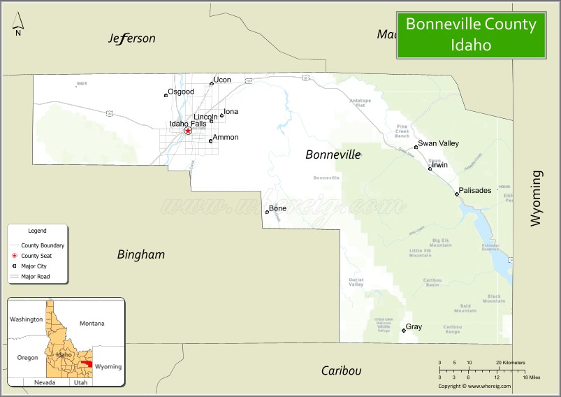
About Bonneville County Map, Idaho: The map showing the county boundary, county seat, major cities, highways, water bodies and neighbouring counties.
Most Viewed Links
| Idaho Map | Idaho County Map | Idaho Cities Map |
| Idaho Zipcodes | Airports in Idaho | Where is Idaho |
| Idaho Area Codes | Idaho Blank Map | Idaho River Map |
| Idaho Physical Map | Idaho Road Map |
Map of Bonneville County, Idaho
Bonneville County is a county located in the U.S. state of Idaho. It's county seat is Idaho Falls. As per 2020 census, the population of Bonneville County is 127930 people and population density is square miles. According to the United States Census Bureau, the county has a total area of 1,869 sq mi (4,841 km2). Bonneville County was established on 1911.
Bonneville County Facts
| Continent | North America |
| Country | United States |
| State | Idaho |
| County Seat | Idaho Falls |
| Largest City/Town | Idaho Falls |
| Established | 1911 |
| Total Area | 1,901 sq mi (4,923 sq km) |
| Land Area | 1,868 sq mi (4,839 sq km) |
| Water Area | 33 sq mi (85 sq km) |
| Population | 123,600 (Census 2020) |
| Population Density | 66 people per sq mi |
| Time Zone | Mountain Time Zone (MT) |
| Major Highways | Interstate 15, U.S. Route 20, U.S. Route 26, U.S. Route 91 |
| Major Rivers | Snake River |
| Neighboring Counties | Jefferson County, Madison County, Teton County, Bingham County, Clark County |
| Famous For | Idaho Falls, Snake River Greenbelt, Yellowstone gateway tourism, and outdoor recreation |
| Top Attractions | Idaho Falls River Walk, Museum of Idaho, Yellowstone Bear World nearby area, Heise Hot Springs, Tautphaus Park Zoo |
| Official Website | Official Website |
About Bonneville County, Idaho
Bonneville County is located in eastern Idaho and was established in 1911. The county seat and largest city is Idaho Falls, one of the largest cities in eastern Idaho. Bonneville County is known for its scenic Snake River landscapes, outdoor recreation, regional commerce, proximity to Yellowstone National Park, and growing technology and energy industries connected to the Idaho National Laboratory region. ([en.wikipedia.org](https://en.wikipedia.org/wiki/Bonneville_County,_Idaho?utm_source=chatgpt.com))
Cities and Communities in Bonneville County, Idaho
| City/Town | Population | Latitude & Longitude |
|---|---|---|
| Idaho Falls (county seat) | 64,000+ | 43.4917°N, 112.0333°W |
| Ammon | 17,000+ | 43.4696°N, 111.9833°W |
| Iona | 2,000+ | 43.5235°N, 111.9408°W |
| Ucon | 1,200+ | 43.5971°N, 111.9649°W |
| Swan Valley | Mountain Community | 43.4377°N, 111.3394°W |
| Irwin | Scenic Community | 43.3988°N, 111.2821°W |
| Ririe | 700+ | 43.6271°N, 111.7744°W |
| Bone | Rural Area | 43.3291°N, 111.4377°W |
Best Golf Courses in Bonneville County, Idaho
| Golf Course | Location | Latitude & Longitude |
|---|---|---|
| Pinecrest Golf Course | Idaho Falls | 43.4820°N, 112.0394°W |
| Sand Creek Golf Course | Idaho Falls | 43.5004°N, 112.0071°W |
| Cedar Park Golf Course | Ririe Area | 43.6469°N, 111.7728°W |
| Jefferson Hills Golf Course | Nearby Rigby | 43.6851°N, 111.9207°W |
What are Major Roads and Highways in Bonneville County
Major highways connect Bonneville County with Montana, Utah, Wyoming, Yellowstone National Park, and important transportation corridors across eastern Idaho.
- Interstate 15 - major north-south interstate through Idaho Falls
- U.S. Route 20 - primary route toward Yellowstone National Park and central Idaho
- U.S. Route 26 - scenic highway connecting Idaho Falls with Wyoming and central Idaho
- U.S. Route 91 - regional transportation route through eastern Idaho communities
Neighboring Counties of Bonneville County
- Jefferson County (north)
- Madison County (northeast)
- Teton County (east)
- Bingham County (south)
- Clark County (northwest)
What are Top Attractions in Bonneville County, Idaho
The county offers riverfront parks, museums, wildlife attractions, hot springs, hiking, fishing, and easy access to mountain recreation areas in eastern Idaho.
| Main Sight Name | City | Famous For |
|---|---|---|
| Idaho Falls River Walk | Idaho Falls | Snake River waterfalls, trails, and downtown scenery |
| Museum of Idaho | Idaho Falls | Regional history, science exhibits, and traveling displays |
| Yellowstone Bear World Nearby Area | Rexburg Nearby Region | Drive-through wildlife park and family attractions |
| Heise Hot Springs | Ririe Area | Natural hot pools and recreation facilities |
| Tautphaus Park Zoo | Idaho Falls | Zoo exhibits and family recreation |
| Swan Valley | Eastern County Area | Fishing, mountain scenery, and outdoor recreation |
| Snake River Greenbelt | Idaho Falls | Walking, biking, and riverfront parks |
| Kelly Canyon Ski Resort | Ririe Area | Skiing and snowboarding recreation |
| Palisades Reservoir Nearby Area | Eastern Region | Boating, fishing, and camping |
| Historic Downtown Idaho Falls | Idaho Falls | Shopping, restaurants, and cultural events |
Distance from Bonneville County to Nearby Cities
The following distances are measured by road (driving).
- Idaho Falls to Pocatello, Idaho - 53 mi (85 km)
- Idaho Falls to Rexburg, Idaho - 29 mi (47 km)
- Idaho Falls to Jackson, Wyoming - 91 mi (146 km)
- Idaho Falls to Yellowstone National Park - 109 mi (175 km)
- Idaho Falls to Salt Lake City, Utah - 213 mi (343 km)
- Idaho Falls to Twin Falls, Idaho - 167 mi (269 km)
- Idaho Falls to Boise, Idaho - 281 mi (452 km)
- Idaho Falls to Reno, Nevada - 559 mi (900 km)
- Idaho Falls to Denver, Colorado - 560 mi (901 km)
- Idaho Falls to Las Vegas, Nevada - 579 mi (932 km)
- Idaho Falls to Spokane, Washington - 551 mi (887 km)
- Idaho Falls to Seattle, Washington - 706 mi (1,136 km)
References
- Bonneville County Official Website
- Bonneville County, Idaho - Wikipedia
- U.S. Census Bureau QuickFacts
- Visit Idaho Falls
- Museum of Idaho
- Ada County Map
- Adams County Map
- Bannock County Map
- Bear Lake County Map
- Benewah County Map
- Bingham County Map
- Blaine County Map
- Boise County Map
- Bonner County Map
- Bonneville County Map
- Boundary County Map
- Butte County Map
- Camas County Map
- Canyon County Map
- Caribou County Map
- Cassia County Map
- Clark County Map
- Clearwater County Map
- Custer County Map
- Elmore County Map
- Franklin County Map
- Fremont County Map
- Gem County Map
- Gooding County Map
- Idaho County Map
- Jefferson County Map
- Jerome County Map
- Kootenai County Map
- Latah County Map
- Lemhi County Map
- Lewis County Map
- Lincoln County Map
- Madison County Map
- Minidoka County Map
- Nez Perce County Map
- Oneida County Map
- Owyhee County Map
- Payette County Map
- Power County Map
- Shoshone County Map
- Teton County Map
- Twin Falls County Map
- Valley County Map
- Washington County Map
- Alabama Counties
- Alaska boroughs
- Arizona Counties
- Arkansas Counties
- California County Map
- Colorado Counties
- Connecticut Counties
- Delaware Counties
- Florida County Map
- Georgia County Map
- Hawaii Counties
- Idaho Counties
- Illinois Counties
- Indiana Counties
- Iowa Counties
- Kansas Counties
- Kentucky Counties
- Louisiana Counties
- Maine Counties
- Maryland Counties
- Massachusetts Counties
- Michigan County Map
- Minnesota Counties
- Mississippi Counties
- Missouri Counties
- Montana Counties
- Nebraska Counties
- Nevada Counties
- New York Counties
- New Hampshire Counties
- New Jersey Counties
- New Mexico Counties
- North Carolina Counties
- North Dakota Counties
- Ohio County Map
- Oklahoma Counties
- Oregon Counties
- Pennsylvania Counties
- Rhode Island Counties
- South Carolina Counties
- South Dakota Counties
- Map of Tennessee
- Texas County Map
- Utah Counties
- Vermont Counties
- Virginia Counties
- Washington Counties
- West Virginia Counties
- Wisconsin Counties
- Wyoming Counties