Map of Shoshone County - Shoshone County is a county located in the U.S. state of Idaho. Shoshone County Map showing cities, highways, important places and water bodies. Get Where is Shoshone County located in the map, major cities in Shoshone county, population, areas, and places of interest.
Shoshone County Map, Idaho
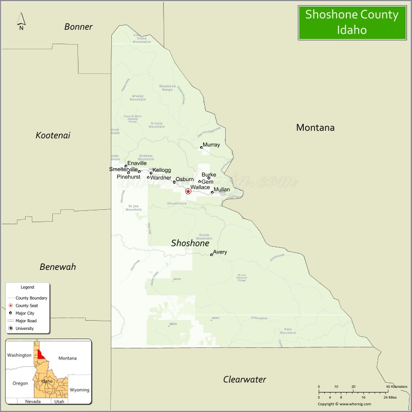
About Shoshone County Map, Idaho: The map showing the county boundary, county seat, major cities, highways, water bodies and neighbouring counties.
Most Viewed Links
| Idaho Map | Idaho County Map | Idaho Cities Map |
| Idaho Zipcodes | Airports in Idaho | Where is Idaho |
| Idaho Area Codes | Idaho Blank Map | Idaho River Map |
| Idaho Physical Map | Idaho Road Map |
Map of Shoshone County, Idaho
Shoshone County is a county located in the U.S. state of Idaho. It's county seat is Wallace. As per 2020 census, the population of Shoshone County is 13612 people and population density is square miles. According to the United States Census Bureau, the county has a total area of 2,634 sq mi (6,822 km2). Shoshone County was established on 1864.
Shoshone County Facts
| Continent | North America |
| Country | United States |
| State | Idaho |
| County Seat | Wallace |
| Largest City/Town | Kellogg |
| Established | 1864 |
| Total Area | 2,635 sq mi (6,825 sq km) |
| Land Area | 2,596 sq mi (6,724 sq km) |
| Water Area | 39 sq mi (101 sq km) |
| Population | 13,169 (Census 2020) |
| Population Density | 5.1 people per sq mi |
| Time Zone | Pacific Time Zone (PT) |
| Major Highways | Interstate 90, Idaho State Highway 3, Idaho State Highway 97 |
| Major Rivers | Coeur d'Alene River, St. Joe River, Clark Fork River nearby area |
| Neighboring Counties | Kootenai County, Benewah County, Clearwater County, Mineral County (Montana), Sanders County (Montana) |
| Famous For | Silver mining history, mountain recreation, skiing, and scenic forests |
| Top Attractions | Silver Mountain Resort, Route of the Hiawatha Trail, Wallace Historic District, Lookout Pass Ski Area, Coeur d'Alene National Forest |
| Official Website | Official Website |
About Shoshone County, Idaho
Shoshone County is located in northern Idaho within the Bitterroot Mountains and was established in 1864. The county seat is Wallace, while Kellogg is the largest city. Shoshone County is famous for its rich silver mining heritage, scenic mountain landscapes, skiing, and outdoor recreation throughout the Silver Valley region. ([en.wikipedia.org](https://en.wikipedia.org/wiki/Shoshone_County,_Idaho?utm_source=chatgpt.com))
Cities and Communities in Shoshone County, Idaho
| City/Town | Population | Latitude & Longitude |
|---|---|---|
| Kellogg | 2,000+ | 47.5380°N, 116.1324°W |
| Wallace (county seat) | 700+ | 47.4741°N, 115.9279°W |
| Smelterville | 600+ | 47.5441°N, 116.1770°W |
| Pinehurst | 1,500+ | 47.5385°N, 116.2382°W |
| Osburn | 1,500+ | 47.5068°N, 115.9993°W |
| Mullan | 700+ | 47.4702°N, 115.7996°W |
| St. Maries Nearby Area | Regional Community | 47.3143°N, 116.5635°W |
| Avery | Historic Mountain Community | 47.2491°N, 115.8015°W |
Best Golf Courses in Shoshone County, Idaho
| Golf Course | Location | Latitude & Longitude |
|---|---|---|
| Galena Ridge Golf Course | Kellogg | 47.5461°N, 116.1575°W |
| Shoshone Golf Club | Wallace Area | 47.4728°N, 115.9341°W |
| Circling Raven Golf Club | Nearby Worley | 47.3972°N, 116.9188°W |
| Coeur d'Alene Resort Golf Course | Nearby Coeur d'Alene | 47.6740°N, 116.7797°W |
What are Major Roads and Highways in Shoshone County
Major highways connect Shoshone County with Montana, Coeur d'Alene, and scenic recreation corridors throughout the Bitterroot Mountains and Silver Valley. ([en.wikipedia.org](https://en.wikipedia.org/wiki/Shoshone_County,_Idaho?utm_source=chatgpt.com))
- Interstate 90 - major east-west interstate through the Silver Valley
- Idaho State Highway 3 - route connecting mountain communities and St. Maries
- Idaho State Highway 97 - scenic highway near Lake Coeur d'Alene
- Route of the Hiawatha Scenic Corridor - historic rail-trail recreation route
Neighboring Counties of Shoshone County
- Kootenai County (west)
- Benewah County (southwest)
- Clearwater County (south)
- Mineral County, Montana (east)
- Sanders County, Montana (northeast)
What are Top Attractions in Shoshone County, Idaho
The county offers skiing, mining museums, mountain biking, hiking, scenic rail-trails, and wilderness recreation throughout northern Idaho mountain regions.
| Main Sight Name | City | Famous For |
|---|---|---|
| Silver Mountain Resort | Kellogg | Skiing, gondola rides, and mountain recreation |
| Route of the Hiawatha Trail | Mullan Area | Scenic biking trail through tunnels and trestles |
| Wallace Historic District | Wallace | Historic mining town and preserved architecture |
| Lookout Pass Ski Area | Mullan Area | Winter sports and mountain scenery |
| Coeur d'Alene National Forest | Countywide | Camping, hiking, and wildlife viewing |
| Old Mission State Park Nearby Area | Southern Region | Historic mission church and cultural history |
| Trail of the Coeur d'Alenes | Silver Valley | Biking and scenic recreation trail |
| Mining Museum | Wallace | Silver mining history exhibits |
| St. Joe River Scenic Area | Southern County | Fishing and wilderness recreation |
| Avery Historic Railroad Area | Avery | Railroad history and mountain scenery |
Distance from Shoshone County to Nearby Cities
The following distances are measured by road (driving).
- Wallace to Coeur d'Alene, Idaho - 50 mi (80 km)
- Wallace to Spokane, Washington - 84 mi (135 km)
- Wallace to Missoula, Montana - 118 mi (190 km)
- Wallace to Sandpoint, Idaho - 96 mi (154 km)
- Wallace to Moscow, Idaho - 142 mi (229 km)
- Wallace to Boise, Idaho - 386 mi (621 km)
- Wallace to Glacier National Park, Montana - 221 mi (356 km)
- Wallace to Seattle, Washington - 382 mi (615 km)
- Wallace to Portland, Oregon - 420 mi (676 km)
- Wallace to Salt Lake City, Utah - 622 mi (1,001 km)
- Wallace to Denver, Colorado - 934 mi (1,503 km)
- Wallace to Vancouver, British Columbia - 391 mi (629 km)
References
- Shoshone County Official Website
- Shoshone County, Idaho - Wikipedia
- U.S. Census Bureau QuickFacts
- Visit Idaho Tourism
- Silver Mountain Resort
- Ada County Map
- Adams County Map
- Bannock County Map
- Bear Lake County Map
- Benewah County Map
- Bingham County Map
- Blaine County Map
- Boise County Map
- Bonner County Map
- Bonneville County Map
- Boundary County Map
- Butte County Map
- Camas County Map
- Canyon County Map
- Caribou County Map
- Cassia County Map
- Clark County Map
- Clearwater County Map
- Custer County Map
- Elmore County Map
- Franklin County Map
- Fremont County Map
- Gem County Map
- Gooding County Map
- Idaho County Map
- Jefferson County Map
- Jerome County Map
- Kootenai County Map
- Latah County Map
- Lemhi County Map
- Lewis County Map
- Lincoln County Map
- Madison County Map
- Minidoka County Map
- Nez Perce County Map
- Oneida County Map
- Owyhee County Map
- Payette County Map
- Power County Map
- Shoshone County Map
- Teton County Map
- Twin Falls County Map
- Valley County Map
- Washington County Map
- Alabama Counties
- Alaska boroughs
- Arizona Counties
- Arkansas Counties
- California County Map
- Colorado Counties
- Connecticut Counties
- Delaware Counties
- Florida County Map
- Georgia County Map
- Hawaii Counties
- Idaho Counties
- Illinois Counties
- Indiana Counties
- Iowa Counties
- Kansas Counties
- Kentucky Counties
- Louisiana Counties
- Maine Counties
- Maryland Counties
- Massachusetts Counties
- Michigan County Map
- Minnesota Counties
- Mississippi Counties
- Missouri Counties
- Montana Counties
- Nebraska Counties
- Nevada Counties
- New York Counties
- New Hampshire Counties
- New Jersey Counties
- New Mexico Counties
- North Carolina Counties
- North Dakota Counties
- Ohio County Map
- Oklahoma Counties
- Oregon Counties
- Pennsylvania Counties
- Rhode Island Counties
- South Carolina Counties
- South Dakota Counties
- Map of Tennessee
- Texas County Map
- Utah Counties
- Vermont Counties
- Virginia Counties
- Washington Counties
- West Virginia Counties
- Wisconsin Counties
- Wyoming Counties