Map of Bingham County - Bingham County is a county located in the U.S. state of Idaho. Bingham County Map showing cities, highways, important places and water bodies. Get Where is Bingham County located in the map, major cities in Bingham county, population, areas, and places of interest.
Bingham County Map, Idaho
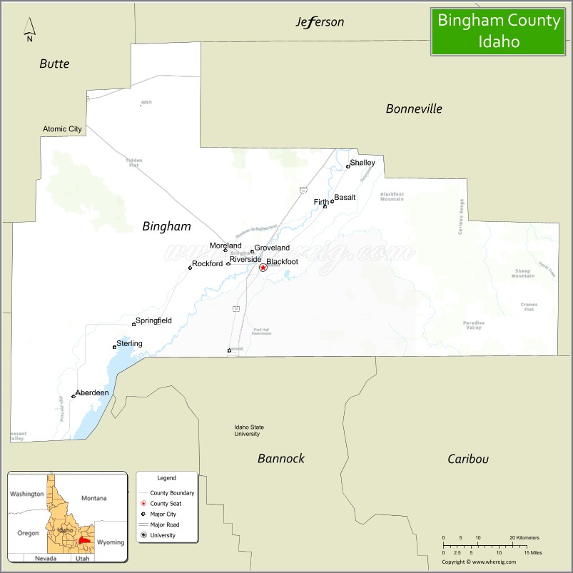
About Bingham County Map, Idaho: The map showing the county boundary, county seat, major cities, highways, water bodies and neighbouring counties.
Most Viewed Links
| Idaho Map | Idaho County Map | Idaho Cities Map |
| Idaho Zipcodes | Airports in Idaho | Where is Idaho |
| Idaho Area Codes | Idaho Blank Map | Idaho River Map |
| Idaho Physical Map | Idaho Road Map |
Map of Bingham County, Idaho
Bingham County is a county located in the U.S. state of Idaho. It's county seat is Blackfoot. As per 2020 census, the population of Bingham County is 48876 people and population density is square miles. According to the United States Census Bureau, the county has a total area of 2,095 sq mi (5,426 km2). Bingham County was established on 1885.
Bingham County Facts
| Continent | North America |
| Country | United States |
| State | Idaho |
| County Seat | Blackfoot |
| Largest City/Town | Blackfoot |
| Established | 1885 |
| Total Area | 2,120 sq mi (5,491 sq km) |
| Land Area | 2,094 sq mi (5,423 sq km) |
| Water Area | 26 sq mi (67 sq km) |
| Population | 47,992 (Census 2020) |
| Population Density | 23 people per sq mi |
| Time Zone | Mountain Time Zone (MT) |
| Major Highways | Interstate 15, U.S. Route 20, U.S. Route 26, U.S. Route 91, Idaho State Highway 39 |
| Major Rivers | Snake River, Blackfoot River |
| Neighboring Counties | Jefferson County, Bonneville County, Caribou County, Bannock County, Power County, Blaine County, Butte County |
| Famous For | Potato farming, Blackfoot city, lava fields, outdoor recreation, and agricultural heritage |
| Top Attractions | Idaho Potato Museum, Hell’s Half Acre Lava Field, Eastern Idaho State Fair, Blackfoot Reservoir, Fort Hall Replica |
| Official Website | Official Website |
About Bingham County, Idaho
Bingham County is located in southeastern Idaho and was established in 1885 with Blackfoot serving as the county seat. The county is part of the Idaho Falls-Blackfoot regional area and is widely known for agriculture, especially potato production, as well as lava landscapes, reservoirs, outdoor recreation, and scenic Snake River Plain geography. :contentReference[oaicite:0]{index=0}
Cities and Communities in Bingham County, Idaho
| City/Town | Population | Latitude & Longitude |
|---|---|---|
| Blackfoot (county seat) | 12,000+ | 43.1905°N, 112.3440°W |
| Shelley | 4,700+ | 43.3813°N, 112.1230°W |
| Aberdeen | 1,700+ | 42.9441°N, 112.8386°W |
| Firth | 500+ | 43.3049°N, 112.1836°W |
| Basalt | 300+ | 43.3127°N, 112.1097°W |
| Fort Hall | Community Area | 43.0335°N, 112.4380°W |
| Moreland | 1,200+ | 43.1908°N, 112.4382°W |
| Riverside | 900+ | 43.1785°N, 112.4384°W |
Best Golf Courses in Bingham County, Idaho
| Golf Course | Location | Latitude & Longitude |
|---|---|---|
| Blackfoot Golf Course | Blackfoot | 43.1895°N, 112.3609°W |
| Riverside Golf Course | Nearby Pocatello | 42.8769°N, 112.4748°W |
| Sand Creek Golf Course | Nearby Idaho Falls | 43.5004°N, 112.0071°W |
| Pinecrest Municipal Golf Course | Nearby Idaho Falls | 43.4820°N, 112.0394°W |
What are Major Roads and Highways in Bingham County
Major highways connect Bingham County with eastern Idaho, Utah, Montana, and important agricultural and transportation corridors throughout the Snake River Plain. :contentReference[oaicite:1]{index=1}
- Interstate 15 - major north-south interstate through Blackfoot and Shelley
- U.S. Route 20 - important regional highway connecting eastern Idaho communities
- U.S. Route 26 - transportation corridor across the Snake River Plain
- U.S. Route 91 - regional route serving agricultural communities
- Idaho State Highway 39 - connects Blackfoot with Aberdeen and surrounding areas
Neighboring Counties of Bingham County
- Jefferson County (north)
- Bonneville County (east)
- Caribou County (southeast)
- Bannock County (south)
- Power County (southwest)
- Blaine County (west)
- Butte County (northwest)
What are Top Attractions in Bingham County, Idaho
The county offers museums, lava fields, agricultural attractions, reservoirs, outdoor recreation, and historic sites throughout southeastern Idaho. :contentReference[oaicite:2]{index=2}
| Main Sight Name | City | Famous For |
|---|---|---|
| Idaho Potato Museum | Blackfoot | Potato industry exhibits and Idaho agriculture history |
| Hell’s Half Acre Lava Field | Western County Area | Volcanic lava landscape and hiking trails |
| Eastern Idaho State Fair | Blackfoot | Annual fair, concerts, and agricultural exhibitions |
| Blackfoot Reservoir | Eastern Region | Boating, fishing, and camping recreation |
| Fort Hall Replica | Blackfoot Area | Historic Oregon Trail and pioneer heritage |
| Snake River Recreation Areas | Countywide | Fishing, boating, and wildlife viewing |
| Bingham County Historical Museum | Blackfoot | Regional pioneer and railroad history |
| Wolverine Canyon | Countywide | Camping and outdoor recreation |
| American Falls Reservoir Nearby Area | Southwestern Region | Water sports and fishing opportunities |
| Blackfoot River Areas | Countywide | Scenic river landscapes and recreation |
Distance from Bingham County to Nearby Cities
The following distances are measured by road (driving).
- Blackfoot to Idaho Falls, Idaho - 26 mi (42 km)
- Blackfoot to Pocatello, Idaho - 26 mi (42 km)
- Blackfoot to Twin Falls, Idaho - 133 mi (214 km)
- Blackfoot to Salt Lake City, Utah - 194 mi (312 km)
- Blackfoot to Jackson, Wyoming - 111 mi (179 km)
- Blackfoot to Boise, Idaho - 238 mi (383 km)
- Blackfoot to Yellowstone National Park - 142 mi (229 km)
- Blackfoot to Reno, Nevada - 530 mi (853 km)
- Blackfoot to Denver, Colorado - 565 mi (909 km)
- Blackfoot to Las Vegas, Nevada - 560 mi (901 km)
- Blackfoot to Spokane, Washington - 523 mi (842 km)
- Blackfoot to Seattle, Washington - 678 mi (1,091 km)
References
- Bingham County Official Website
- Bingham County, Idaho - Wikipedia
- U.S. Census Bureau QuickFacts
- Visit Idaho Tourism
- Idaho Potato Museum
- Ada County Map
- Adams County Map
- Bannock County Map
- Bear Lake County Map
- Benewah County Map
- Bingham County Map
- Blaine County Map
- Boise County Map
- Bonner County Map
- Bonneville County Map
- Boundary County Map
- Butte County Map
- Camas County Map
- Canyon County Map
- Caribou County Map
- Cassia County Map
- Clark County Map
- Clearwater County Map
- Custer County Map
- Elmore County Map
- Franklin County Map
- Fremont County Map
- Gem County Map
- Gooding County Map
- Idaho County Map
- Jefferson County Map
- Jerome County Map
- Kootenai County Map
- Latah County Map
- Lemhi County Map
- Lewis County Map
- Lincoln County Map
- Madison County Map
- Minidoka County Map
- Nez Perce County Map
- Oneida County Map
- Owyhee County Map
- Payette County Map
- Power County Map
- Shoshone County Map
- Teton County Map
- Twin Falls County Map
- Valley County Map
- Washington County Map
- Alabama Counties
- Alaska boroughs
- Arizona Counties
- Arkansas Counties
- California County Map
- Colorado Counties
- Connecticut Counties
- Delaware Counties
- Florida County Map
- Georgia County Map
- Hawaii Counties
- Idaho Counties
- Illinois Counties
- Indiana Counties
- Iowa Counties
- Kansas Counties
- Kentucky Counties
- Louisiana Counties
- Maine Counties
- Maryland Counties
- Massachusetts Counties
- Michigan County Map
- Minnesota Counties
- Mississippi Counties
- Missouri Counties
- Montana Counties
- Nebraska Counties
- Nevada Counties
- New York Counties
- New Hampshire Counties
- New Jersey Counties
- New Mexico Counties
- North Carolina Counties
- North Dakota Counties
- Ohio County Map
- Oklahoma Counties
- Oregon Counties
- Pennsylvania Counties
- Rhode Island Counties
- South Carolina Counties
- South Dakota Counties
- Map of Tennessee
- Texas County Map
- Utah Counties
- Vermont Counties
- Virginia Counties
- Washington Counties
- West Virginia Counties
- Wisconsin Counties
- Wyoming Counties