Map of Power County - Power County is a county located in the U.S. state of Idaho. Power County Map showing cities, highways, important places and water bodies. Get Where is Power County located in the map, major cities in Power county, population, areas, and places of interest.
Power County Map, Idaho
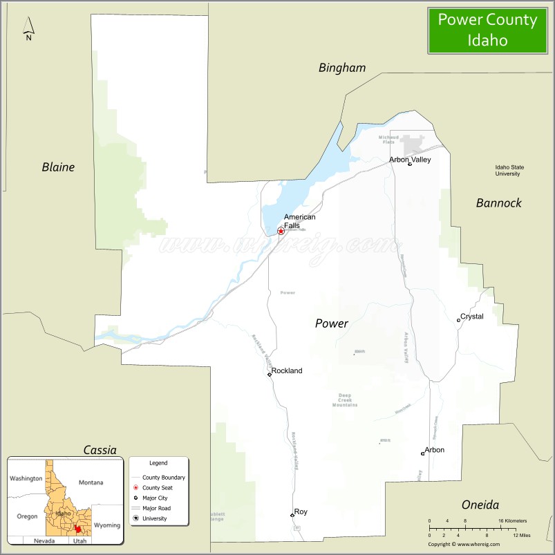
About Power County Map, Idaho: The map showing the county boundary, county seat, major cities, highways, water bodies and neighbouring counties.
Most Viewed Links
| Idaho Map | Idaho County Map | Idaho Cities Map |
| Idaho Zipcodes | Airports in Idaho | Where is Idaho |
| Idaho Area Codes | Idaho Blank Map | Idaho River Map |
| Idaho Physical Map | Idaho Road Map |
Map of Power County, Idaho
Power County is a county located in the U.S. state of Idaho. It's county seat is American Falls. As per 2020 census, the population of Power County is 7950 people and population density is square miles. According to the United States Census Bureau, the county has a total area of 1,406 sq mi (3,642 km2). Power County was established on 1913.
Power County Facts
| Continent | North America |
| Country | United States |
| State | Idaho |
| County Seat | American Falls |
| Largest City/Town | American Falls |
| Established | 1913 |
| Total Area | 1,443 sq mi (3,737 sq km) |
| Land Area | 1,404 sq mi (3,636 sq km) |
| Water Area | 38 sq mi (98 sq km) |
| Population | 7,878 (Census 2020) |
| Population Density | 5.5 people per sq mi |
| Time Zone | Mountain Time Zone (MT) |
| Major Highways | Interstate 86, U.S. Route 30, Idaho State Highway 37, Idaho State Highway 39 |
| Major Rivers | Snake River, Portneuf River nearby area |
| Neighboring Counties | Bannock County, Oneida County, Bingham County, Blaine County, Cassia County |
| Famous For | American Falls Reservoir, agriculture, hydroelectric history, and outdoor recreation |
| Top Attractions | American Falls Reservoir, Massacre Rocks State Park, Minidoka National Wildlife Refuge nearby area, Craters of the Moon nearby region, Power County Museum |
| Official Website | Official Website |
About Power County, Idaho
Power County is located in southeastern Idaho and was established in 1913 from parts of Cassia County. The county seat and largest city is American Falls. Power County is known for the American Falls Dam and Reservoir, irrigated agriculture, scenic open plains, and outdoor recreation opportunities along the Snake River. :contentReference[oaicite:0]{index=0}
Cities and Communities in Power County, Idaho
| City/Town | Population | Latitude & Longitude |
|---|---|---|
| American Falls (county seat) | 4,000+ | 42.7860°N, 112.8544°W |
| Rockland | 300+ | 42.5716°N, 112.8769°W |
| Arbon Valley | 600+ | 42.4978°N, 112.5546°W |
| Arbon | Rural Community | 42.4920°N, 112.5488°W |
| Neeley | Small Community | 42.8010°N, 112.9176°W |
| Pauline | Agricultural Community | 42.6637°N, 112.7362°W |
| Roy | Historic Community | 42.7418°N, 112.9397°W |
| American Falls Reservoir Area | Recreation Region | 42.7828°N, 112.8784°W |
Best Golf Courses in Power County, Idaho
| Golf Course | Location | Latitude & Longitude |
|---|---|---|
| Riverside Golf Course | Nearby Pocatello | 42.8710°N, 112.4522°W |
| Juniper Hills Country Club | Nearby Pocatello | 42.8953°N, 112.4328°W |
| Rivers Edge Golf Club | Nearby Burley | 42.5657°N, 113.7845°W |
| Blackfoot Golf Course | Nearby Blackfoot | 43.1877°N, 112.3381°W |
What are Major Roads and Highways in Power County
Major highways connect Power County with southeastern Idaho farming communities, recreation areas, and transportation corridors across the Snake River Plain. :contentReference[oaicite:1]{index=1}
- Interstate 86 - major east-west interstate through southern Idaho
- U.S. Route 30 - important regional highway through American Falls
- Idaho State Highway 37 - roadway connecting Rockland and nearby valleys
- Idaho State Highway 39 - scenic route through agricultural communities
Neighboring Counties of Power County
- Bannock County (east)
- Oneida County (south)
- Bingham County (north)
- Blaine County (northwest)
- Cassia County (southwest)
What are Top Attractions in Power County, Idaho
The county offers reservoirs, fishing, camping, wildlife viewing, volcanic landscapes, and scenic recreation areas throughout southeastern Idaho. :contentReference[oaicite:2]{index=2}
| Main Sight Name | City | Famous For |
|---|---|---|
| American Falls Reservoir | American Falls | Boating, fishing, and water recreation |
| Massacre Rocks State Park | American Falls Area | Oregon Trail history and camping |
| Minidoka National Wildlife Refuge Nearby Area | Western Region | Birdwatching and wildlife habitat |
| Craters of the Moon Nearby Region | Northwestern Area | Volcanic landscapes and lava fields |
| Power County Museum | American Falls | Local pioneer and agricultural history |
| American Falls Dam | American Falls | Hydroelectric and irrigation engineering landmark |
| Snake River Recreation Areas | Countywide | Fishing, boating, and scenic river views |
| Rockland Valley | Rockland | Rural scenery and farming landscapes |
| Arbon Valley Scenic Area | Arbon Valley | Open plains and mountain views |
| Oregon Trail Historic Routes | Countywide | Pioneer migration history and interpretive sites |
Distance from Power County to Nearby Cities
The following distances are measured by road (driving).
- American Falls to Pocatello, Idaho - 27 mi (43 km)
- American Falls to Blackfoot, Idaho - 49 mi (79 km)
- American Falls to Burley, Idaho - 49 mi (79 km)
- American Falls to Idaho Falls, Idaho - 74 mi (119 km)
- American Falls to Twin Falls, Idaho - 89 mi (143 km)
- American Falls to Boise, Idaho - 191 mi (307 km)
- American Falls to Salt Lake City, Utah - 166 mi (267 km)
- American Falls to Jackson, Wyoming - 129 mi (208 km)
- American Falls to Yellowstone National Park - 176 mi (283 km)
- American Falls to Denver, Colorado - 594 mi (956 km)
- American Falls to Reno, Nevada - 511 mi (822 km)
- American Falls to Spokane, Washington - 563 mi (906 km)
References
- Power County Official Website
- Power County, Idaho - Wikipedia
- State of Idaho - Power County
- U.S. Census Bureau QuickFacts
- Visit Idaho Tourism
- Ada County Map
- Adams County Map
- Bannock County Map
- Bear Lake County Map
- Benewah County Map
- Bingham County Map
- Blaine County Map
- Boise County Map
- Bonner County Map
- Bonneville County Map
- Boundary County Map
- Butte County Map
- Camas County Map
- Canyon County Map
- Caribou County Map
- Cassia County Map
- Clark County Map
- Clearwater County Map
- Custer County Map
- Elmore County Map
- Franklin County Map
- Fremont County Map
- Gem County Map
- Gooding County Map
- Idaho County Map
- Jefferson County Map
- Jerome County Map
- Kootenai County Map
- Latah County Map
- Lemhi County Map
- Lewis County Map
- Lincoln County Map
- Madison County Map
- Minidoka County Map
- Nez Perce County Map
- Oneida County Map
- Owyhee County Map
- Payette County Map
- Power County Map
- Shoshone County Map
- Teton County Map
- Twin Falls County Map
- Valley County Map
- Washington County Map
- Alabama Counties
- Alaska boroughs
- Arizona Counties
- Arkansas Counties
- California County Map
- Colorado Counties
- Connecticut Counties
- Delaware Counties
- Florida County Map
- Georgia County Map
- Hawaii Counties
- Idaho Counties
- Illinois Counties
- Indiana Counties
- Iowa Counties
- Kansas Counties
- Kentucky Counties
- Louisiana Counties
- Maine Counties
- Maryland Counties
- Massachusetts Counties
- Michigan County Map
- Minnesota Counties
- Mississippi Counties
- Missouri Counties
- Montana Counties
- Nebraska Counties
- Nevada Counties
- New York Counties
- New Hampshire Counties
- New Jersey Counties
- New Mexico Counties
- North Carolina Counties
- North Dakota Counties
- Ohio County Map
- Oklahoma Counties
- Oregon Counties
- Pennsylvania Counties
- Rhode Island Counties
- South Carolina Counties
- South Dakota Counties
- Map of Tennessee
- Texas County Map
- Utah Counties
- Vermont Counties
- Virginia Counties
- Washington Counties
- West Virginia Counties
- Wisconsin Counties
- Wyoming Counties