Map of Latah County - Latah County is a county located in the U.S. state of Idaho. Latah County Map showing cities, highways, important places and water bodies. Get Where is Latah County located in the map, major cities in Latah county, population, areas, and places of interest.
Latah County Map, Idaho
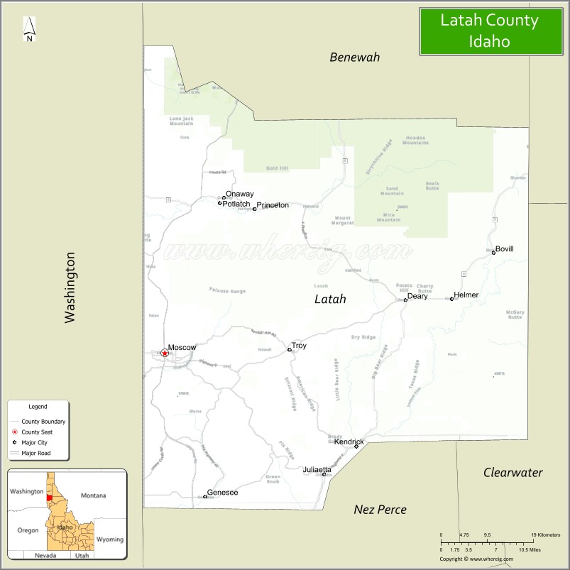
About Latah County Map, Idaho: The map showing the county boundary, county seat, major cities, highways, water bodies and neighbouring counties.
Most Viewed Links
| Idaho Map | Idaho County Map | Idaho Cities Map |
| Idaho Zipcodes | Airports in Idaho | Where is Idaho |
| Idaho Area Codes | Idaho Blank Map | Idaho River Map |
| Idaho Physical Map | Idaho Road Map |
Map of Latah County, Idaho
Latah County is a county located in the U.S. state of Idaho. It's county seat is Moscow. As per 2020 census, the population of Latah County is 40313 people and population density is square miles. According to the United States Census Bureau, the county has a total area of 1,077 sq mi (2,789 km2). Latah County was established on 1888.
Latah County Facts
| Continent | North America |
| Country | United States |
| State | Idaho |
| County Seat | Moscow |
| Largest City/Town | Moscow |
| Established | 1888 |
| Total Area | 1,078 sq mi (2,792 sq km) |
| Land Area | 1,076 sq mi (2,787 sq km) |
| Water Area | 2 sq mi (5 sq km) |
| Population | 40,313 (Census 2020) |
| Population Density | 37 people per sq mi |
| Time Zone | Pacific Time Zone (PT) |
| Major Highways | U.S. Route 95, Idaho State Highway 8, Idaho State Highway 6 |
| Major Rivers | Palouse River, Potlatch River, Clearwater River nearby area |
| Neighboring Counties | Benewah County, Shoshone County, Clearwater County, Nez Perce County, Whitman County (Washington) |
| Famous For | University of Idaho, rolling Palouse hills, agriculture, and college-town culture |
| Top Attractions | University of Idaho, Arboretum & Botanical Garden, McConnell Mansion Museum, Moscow Mountain, Appaloosa Museum nearby area |
| Official Website | Official Website |
About Latah County, Idaho
Latah County is located in north-central Idaho along the Washington border and was established in 1888. The county seat and largest city is Moscow. Latah County is known for the University of Idaho, scenic Palouse farmland, vibrant arts and culture, outdoor recreation, and strong agricultural traditions throughout the rolling hills of the Inland Northwest. ([en.wikipedia.org](https://en.wikipedia.org/wiki/Latah_County,_Idaho?utm_source=chatgpt.com))
Cities and Communities in Latah County, Idaho
| City/Town | Population | Latitude & Longitude |
|---|---|---|
| Moscow (county seat) | 25,000+ | 46.7324°N, 117.0002°W |
| Troy | 900+ | 46.7360°N, 116.7693°W |
| Potlatch | 700+ | 46.9213°N, 116.8985°W |
| Kendrick | 400+ | 46.6146°N, 116.6463°W |
| Juliaetta | 600+ | 46.5785°N, 116.7063°W |
| Genesee | 1,000+ | 46.5527°N, 116.9257°W |
| Deary | 500+ | 46.7996°N, 116.5604°W |
| Bovill | 300+ | 46.8591°N, 116.3938°W |
Best Golf Courses in Latah County, Idaho
| Golf Course | Location | Latitude & Longitude |
|---|---|---|
| University of Idaho Golf Course | Moscow | 46.7315°N, 117.0178°W |
| Elk River Golf Course | Elk River Area | 46.7840°N, 116.1779°W |
| Clarkston Golf & Country Club | Nearby Clarkston, Washington | 46.3951°N, 117.0610°W |
| Pullman Country Club | Nearby Pullman, Washington | 46.7445°N, 117.1812°W |
What are Major Roads and Highways in Latah County
Major highways connect Latah County with Washington state, northern Idaho forests, and agricultural communities throughout the Palouse region. ([en.wikipedia.org](https://en.wikipedia.org/wiki/Latah_County,_Idaho?utm_source=chatgpt.com))
- U.S. Route 95 - major north-south highway through Moscow and northern Idaho
- Idaho State Highway 8 - route connecting Moscow with Pullman, Washington
- Idaho State Highway 6 - scenic highway through forested eastern communities
- Palouse Scenic Byways - rural routes through rolling wheat fields and farmland
Neighboring Counties of Latah County
- Benewah County (north)
- Shoshone County (northeast)
- Clearwater County (east)
- Nez Perce County (south)
- Whitman County, Washington (west)
What are Top Attractions in Latah County, Idaho
The county offers university attractions, museums, hiking, scenic farmland, cultural festivals, and outdoor recreation throughout the Palouse region. ([visitidaho.org](https://visitidaho.org/?utm_source=chatgpt.com))
| Main Sight Name | City | Famous For |
|---|---|---|
| University of Idaho | Moscow | Historic university campus and cultural events |
| Arboretum & Botanical Garden | Moscow | Gardens, walking trails, and seasonal flowers |
| McConnell Mansion Museum | Moscow | Historic Victorian home and local history |
| Moscow Mountain | Moscow Area | Hiking, biking, and scenic overlooks |
| Appaloosa Museum Nearby Area | Moscow Region | Horse breed history and exhibits |
| Palouse Scenic Byways | Countywide | Rolling farmland landscapes and photography |
| Hamilton-Lowe Aquatics Center | Moscow | Family recreation and swimming |
| Troy Historic District | Troy | Historic small-town architecture |
| Potlatch Historical Museum | Potlatch | Logging and railroad history |
| Deary Forest Recreation Areas | Deary | Camping, hiking, and wildlife viewing |
Distance from Latah County to Nearby Cities
The following distances are measured by road (driving).
- Moscow to Pullman, Washington - 9 mi (14 km)
- Moscow to Lewiston, Idaho - 32 mi (51 km)
- Moscow to Coeur d'Alene, Idaho - 92 mi (148 km)
- Moscow to Spokane, Washington - 85 mi (137 km)
- Moscow to Boise, Idaho - 300 mi (483 km)
- Moscow to Missoula, Montana - 199 mi (320 km)
- Moscow to Seattle, Washington - 298 mi (480 km)
- Moscow to Portland, Oregon - 356 mi (573 km)
- Moscow to Salt Lake City, Utah - 624 mi (1,004 km)
- Moscow to Denver, Colorado - 938 mi (1,510 km)
- Moscow to Vancouver, British Columbia - 395 mi (636 km)
- Moscow to Glacier National Park, Montana - 277 mi (446 km)
References
- Latah County Official Website
- Latah County, Idaho - Wikipedia
- U.S. Census Bureau QuickFacts
- Visit Idaho Tourism
- University of Idaho
- Ada County Map
- Adams County Map
- Bannock County Map
- Bear Lake County Map
- Benewah County Map
- Bingham County Map
- Blaine County Map
- Boise County Map
- Bonner County Map
- Bonneville County Map
- Boundary County Map
- Butte County Map
- Camas County Map
- Canyon County Map
- Caribou County Map
- Cassia County Map
- Clark County Map
- Clearwater County Map
- Custer County Map
- Elmore County Map
- Franklin County Map
- Fremont County Map
- Gem County Map
- Gooding County Map
- Idaho County Map
- Jefferson County Map
- Jerome County Map
- Kootenai County Map
- Latah County Map
- Lemhi County Map
- Lewis County Map
- Lincoln County Map
- Madison County Map
- Minidoka County Map
- Nez Perce County Map
- Oneida County Map
- Owyhee County Map
- Payette County Map
- Power County Map
- Shoshone County Map
- Teton County Map
- Twin Falls County Map
- Valley County Map
- Washington County Map
- Alabama Counties
- Alaska boroughs
- Arizona Counties
- Arkansas Counties
- California County Map
- Colorado Counties
- Connecticut Counties
- Delaware Counties
- Florida County Map
- Georgia County Map
- Hawaii Counties
- Idaho Counties
- Illinois Counties
- Indiana Counties
- Iowa Counties
- Kansas Counties
- Kentucky Counties
- Louisiana Counties
- Maine Counties
- Maryland Counties
- Massachusetts Counties
- Michigan County Map
- Minnesota Counties
- Mississippi Counties
- Missouri Counties
- Montana Counties
- Nebraska Counties
- Nevada Counties
- New York Counties
- New Hampshire Counties
- New Jersey Counties
- New Mexico Counties
- North Carolina Counties
- North Dakota Counties
- Ohio County Map
- Oklahoma Counties
- Oregon Counties
- Pennsylvania Counties
- Rhode Island Counties
- South Carolina Counties
- South Dakota Counties
- Map of Tennessee
- Texas County Map
- Utah Counties
- Vermont Counties
- Virginia Counties
- Washington Counties
- West Virginia Counties
- Wisconsin Counties
- Wyoming Counties