Map of Elmore County - Elmore County is a county located in the U.S. state of Idaho. Elmore County Map showing cities, highways, important places and water bodies. Get Where is Elmore County located in the map, major cities in Elmore county, population, areas, and places of interest.
Elmore County Map, Idaho
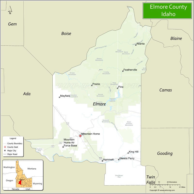
About Elmore County Map, Idaho: The map showing the county boundary, county seat, major cities, highways, water bodies and neighbouring counties.
Most Viewed Links
| Idaho Map | Idaho County Map | Idaho Cities Map |
| Idaho Zipcodes | Airports in Idaho | Where is Idaho |
| Idaho Area Codes | Idaho Blank Map | Idaho River Map |
| Idaho Physical Map | Idaho Road Map |
Map of Elmore County, Idaho
Elmore County is a county located in the U.S. state of Idaho. It's county seat is Mountain Home. As per 2020 census, the population of Elmore County is 28827 people and population density is square miles. According to the United States Census Bureau, the county has a total area of 3,078 sq mi (7,972 km2). Elmore County was established on 1889.
Elmore County Facts
| Continent | North America |
| Country | United States |
| State | Idaho |
| County Seat | Mountain Home |
| Largest City/Town | Mountain Home |
| Established | 1889 |
| Total Area | 3,101 sq mi (8,031 sq km) |
| Land Area | 3,075 sq mi (7,964 sq km) |
| Water Area | 26 sq mi (67 sq km) |
| Population | 28,666 (Census 2020) |
| Population Density | 9 people per sq mi |
| Time Zone | Mountain Time Zone (MT) |
| Major Highways | Interstate 84, U.S. Route 20, U.S. Route 26, Idaho State Highway 51 |
| Major Rivers | Snake River, Boise River, Bruneau River |
| Neighboring Counties | Boise County, Camas County, Owyhee County, Ada County, Gooding County, Blaine County |
| Famous For | Mountain Home Air Force Base, Bruneau Dunes, Snake River Canyon, and outdoor recreation |
| Top Attractions | Bruneau Dunes State Park, Mountain Home Air Force Base Museum, Anderson Ranch Reservoir, Three Island Crossing nearby area, Snake River Birds of Prey Area |
| Official Website | Official Website |
About Elmore County, Idaho
Elmore County is located in southwestern Idaho and was established in 1889. The county seat and largest city is Mountain Home. Elmore County is known for desert landscapes, military history, scenic reservoirs, sand dunes, and outdoor recreation throughout the Snake River Plain and surrounding mountain regions. ([en.wikipedia.org](https://en.wikipedia.org/wiki/Elmore_County,_Idaho?utm_source=chatgpt.com))
Cities and Communities in Elmore County, Idaho
| City/Town | Population | Latitude & Longitude |
|---|---|---|
| Mountain Home (county seat) | 15,000+ | 43.1329°N, 115.6912°W |
| Glenns Ferry | 1,300+ | 42.9549°N, 115.3001°W |
| Pine | Mountain Community | 43.4877°N, 115.3082°W |
| Atlanta | Historic Mining Town | 43.8010°N, 115.1354°W |
| Featherville | Scenic Community | 43.6071°N, 115.2404°W |
| Prairie | Mountain Area | 43.4990°N, 115.5597°W |
| Hammett | Agricultural Community | 43.2394°N, 115.4154°W |
| King Hill | Snake River Community | 43.0048°N, 115.2025°W |
Best Golf Courses in Elmore County, Idaho
| Golf Course | Location | Latitude & Longitude |
|---|---|---|
| Mountain Home Golf Course | Mountain Home | 43.1308°N, 115.6981°W |
| Prairie Golf Course | Prairie Area | 43.4977°N, 115.5601°W |
| Falcon Crest Golf Club | Nearby Kuna | 43.4870°N, 116.3977°W |
| BanBury Golf Course | Nearby Eagle | 43.6944°N, 116.3545°W |
What are Major Roads and Highways in Elmore County
Major highways connect Elmore County with Boise, southern Idaho communities, and important transportation corridors across the Snake River Plain. ([en.wikipedia.org](https://en.wikipedia.org/wiki/Elmore_County,_Idaho?utm_source=chatgpt.com))
- Interstate 84 - major east-west interstate through Mountain Home and Glenns Ferry
- U.S. Route 20 - important regional transportation corridor
- U.S. Route 26 - route serving southern Idaho agricultural and recreation regions
- Idaho State Highway 51 - scenic highway toward Owyhee desert regions
Neighboring Counties of Elmore County
- Boise County (north)
- Camas County (east)
- Owyhee County (southwest)
- Ada County (west)
- Gooding County (southeast)
- Blaine County (northeast)
What are Top Attractions in Elmore County, Idaho
The county offers state parks, reservoirs, dunes, fishing, hiking, military history, and scenic desert recreation opportunities across southwestern Idaho. ([visitidaho.org](https://visitidaho.org/?utm_source=chatgpt.com))
| Main Sight Name | City | Famous For |
|---|---|---|
| Bruneau Dunes State Park | Southern Elmore County | Massive sand dunes, camping, and observatory |
| Mountain Home Air Force Base Museum | Mountain Home Area | Military aviation history and exhibits |
| Anderson Ranch Reservoir | Pine Area | Boating, fishing, and mountain recreation |
| Three Island Crossing Nearby Area | Glenns Ferry Region | Historic Oregon Trail crossing site |
| Snake River Birds of Prey Area | Countywide | Wildlife viewing and canyon scenery |
| Atlanta Historic District | Atlanta | Historic mining town and mountain scenery |
| Bruneau Canyon Nearby Area | Southern Region | Scenic canyon drives and wilderness landscapes |
| Boise National Forest Areas | Northern County | Camping, hiking, and wildlife recreation |
| Glenns Ferry Historic Area | Glenns Ferry | Oregon Trail and pioneer heritage |
| CJ Strike Reservoir Nearby Area | Western Region | Fishing and boating recreation |
Distance from Elmore County to Nearby Cities
The following distances are measured by road (driving).
- Mountain Home to Boise, Idaho - 43 mi (69 km)
- Mountain Home to Twin Falls, Idaho - 117 mi (188 km)
- Mountain Home to Sun Valley, Idaho - 116 mi (187 km)
- Mountain Home to Idaho Falls, Idaho - 237 mi (381 km)
- Mountain Home to Pocatello, Idaho - 221 mi (356 km)
- Mountain Home to Salt Lake City, Utah - 323 mi (520 km)
- Mountain Home to Reno, Nevada - 382 mi (615 km)
- Mountain Home to Spokane, Washington - 365 mi (587 km)
- Mountain Home to Portland, Oregon - 411 mi (661 km)
- Mountain Home to Seattle, Washington - 486 mi (782 km)
- Mountain Home to Las Vegas, Nevada - 550 mi (885 km)
- Mountain Home to Denver, Colorado - 780 mi (1,255 km)
References
- Elmore County Official Website
- Elmore County, Idaho - Wikipedia
- U.S. Census Bureau QuickFacts
- Visit Idaho Tourism
- Bruneau Dunes State Park
- Ada County Map
- Adams County Map
- Bannock County Map
- Bear Lake County Map
- Benewah County Map
- Bingham County Map
- Blaine County Map
- Boise County Map
- Bonner County Map
- Bonneville County Map
- Boundary County Map
- Butte County Map
- Camas County Map
- Canyon County Map
- Caribou County Map
- Cassia County Map
- Clark County Map
- Clearwater County Map
- Custer County Map
- Elmore County Map
- Franklin County Map
- Fremont County Map
- Gem County Map
- Gooding County Map
- Idaho County Map
- Jefferson County Map
- Jerome County Map
- Kootenai County Map
- Latah County Map
- Lemhi County Map
- Lewis County Map
- Lincoln County Map
- Madison County Map
- Minidoka County Map
- Nez Perce County Map
- Oneida County Map
- Owyhee County Map
- Payette County Map
- Power County Map
- Shoshone County Map
- Teton County Map
- Twin Falls County Map
- Valley County Map
- Washington County Map
- Alabama Counties
- Alaska boroughs
- Arizona Counties
- Arkansas Counties
- California County Map
- Colorado Counties
- Connecticut Counties
- Delaware Counties
- Florida County Map
- Georgia County Map
- Hawaii Counties
- Idaho Counties
- Illinois Counties
- Indiana Counties
- Iowa Counties
- Kansas Counties
- Kentucky Counties
- Louisiana Counties
- Maine Counties
- Maryland Counties
- Massachusetts Counties
- Michigan County Map
- Minnesota Counties
- Mississippi Counties
- Missouri Counties
- Montana Counties
- Nebraska Counties
- Nevada Counties
- New York Counties
- New Hampshire Counties
- New Jersey Counties
- New Mexico Counties
- North Carolina Counties
- North Dakota Counties
- Ohio County Map
- Oklahoma Counties
- Oregon Counties
- Pennsylvania Counties
- Rhode Island Counties
- South Carolina Counties
- South Dakota Counties
- Map of Tennessee
- Texas County Map
- Utah Counties
- Vermont Counties
- Virginia Counties
- Washington Counties
- West Virginia Counties
- Wisconsin Counties
- Wyoming Counties