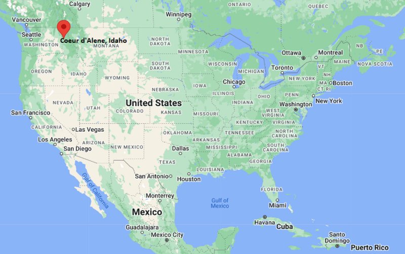
Where is Coeur d'Alene Located? - Coeur d'Alene is a city located in the Kootenai County of Idaho, United States. Coeur d'Alene lies between 41.6764 Degrees North latitudes and 86.2520 Degrees West longitudes.
Location Map of Coeur d'Alene, Idaho
Coeur d'Alene Map, Idaho, USA
Where is Coeur d'Alene?: The Google Map showing the location of Coeur d'Alene in the U.S. state of Idaho.
Where is Coeur d'Alene Located?
Coeur d'Alene is a city located in the Kootenai County of Idaho, United States. Coeur d'Alene lies between 41.6764 Degrees North latitudes and 86.2520 Degrees West longitudes. According to 2020 U.S.census, the population of Coeur d'Alene city is 54628 people and the city has a total area of 16.06 sq mi. The city has numerous parks and recreational facilities.
Transportation and Connectivity in Coeur d'Alene, Idaho
Feature
Details
Airport Name
Coeur d'Alene Airport; Spokane International Airport (nearby)
IATA Code
COE; GEG
Port
Coeur d'Alene Marina
Major Highways
Interstate 90, US 95, ID 41
Train/Amtrak Service
Nearest Amtrak station in Spokane, Washington
Local Bus/Transit Service
Citylink and Kootenai County Transit
Interstate 90 - Primary east-west freeway connecting Coeur d'Alene with Spokane and western Montana.
U.S. Highway 95 - Major north-south highway linking the city with northern and southern Idaho.
Idaho State Highway 41 - Connects Coeur d'Alene with Post Falls, Rathdrum, and surrounding communities.
Northwest Boulevard - Scenic roadway providing access to downtown and Lake Coeur d'Alene.
Sherman Avenue - Main downtown street with shopping, dining, and waterfront attractions.
Key Landmarks and Places to Visit in Coeur d'Alene, Idaho
Landmark Name
Type
Lake Coeur d'Alene
Lake
Coeur d'Alene Resort
Resort
Tubbs Hill
Nature Preserve
McEuen Park
City Park
Coeur d'Alene City Park
Park
Museum of North Idaho
Museum
Silverwood Theme Park
Theme Park
Mineral Ridge National Recreation Trail
Hiking Trail
North Idaho Centennial Trail
Recreation Trail
Coeur d'Alene Resort Golf Course
Golf Resort
Colleges and Universities in Coeur d'Alene, Idaho
Institution Name
Type
Level
Notable For
North Idaho College
Public
Community College
Transfer and workforce education
University of Idaho - Coeur d'Alene
Public
University
Outreach and graduate programs
Lewis-Clark State College - Coeur d'Alene
Public
University
Professional and adult education
Northwest Nazarene University - Coeur d'Alene Center
Private
University
Graduate programs
Carrington College - Spokane (nearby)
Private
College
Healthcare education
Waterbodies in Coeur d'Alene, Idaho
Lake Coeur d'Alene, Spokane River, Hayden Lake, Fernan Lake, Coeur d'Alene River, Fernan Creek, Blackwell Island Channel, Wolf Lodge Creek, Blue Creek Bay, Cougar Bay
Golf Courses in Coeur d'Alene, Idaho
Coeur d'Alene Resort Golf Course, Avondale Golf Club, The Club at Black Rock, Circling Raven Golf Club, Highlands Golf Course, Prairie Falls Golf Club, Hayden Lake Country Club, Twin Lakes Village Golf Club
Coeur d'Alene, Idaho - Key Historical Facts
Coeur d'Alene was founded in the 1870s as a frontier settlement and trading center on the shores of Lake Coeur d'Alene.
The city's name comes from the Coeur d'Alene Tribe, whose ancestors have lived in the region for centuries.
Logging, mining, and steamboat transportation fueled the city's growth during the late 19th and early 20th centuries.
The arrival of the Northern Pacific Railway strengthened Coeur d'Alene as an important commercial center in northern Idaho.
Tourism expanded significantly after the development of lakefront resorts and recreational facilities during the 20th century.
Today, Coeur d'Alene is known for its scenic lake, outdoor recreation, thriving downtown, and role as one of Idaho's leading tourist destinations.