
Where is Emmett Located? - Emmett is a city located in the Gem County of Idaho, United States. Emmett lies between 41.6392 Degrees North latitudes and 87.4548 Degrees West longitudes.
Location Map of Emmett, Idaho
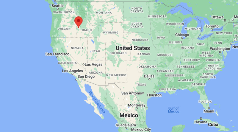
Emmett Map, Idaho, USA
Where is Emmett?: The Google Map showing the location of Emmett in the U.S. state of Idaho.
Where is Emmett Located?
Emmett is a city located in the Gem County of Idaho, United States. Emmett lies between 41.6392 Degrees North latitudes and 87.4548 Degrees West longitudes. According to 2020 U.S.census, the population of Emmett city is 7647 people and the city has a total area of 2.81 sq mi. The city has numerous parks and recreational facilities.
Most Viewed US Maps
| USA Sttae Map | USA Region Map | USA Road Map |
| USA County Map | Where is USA in World Map? | US ZIP Code Map |
| USA Time Zones Map | US State and Capitals Map | USA Physical Map |
Find 4,400+ U.S. Cities by State - Explore Their Locations and Get Detailed Information
Emmett, Idaho Quick Facts
| Property | Details |
|---|---|
| City | Emmett |
| County | Gem County |
| State | Idaho |
| State Capital | Boise |
| US Region | West |
| Latitude | 43.8735°N |
| Longitude | 116.4993°W |
| Elevation | 2,415 ft (736 m) |
| Land Area | 2.85 sq mi |
| Water Area | 0.02 sq mi |
| Total Area | 2.87 sq mi |
| Population (2020 Census) | 7,647 |
| Population Density | Approximately 2,683 per sq mi |
| ZIP Code | 83617 |
| Area Code | 208, 986 |
| Time Zone Standard | Mountain Standard Time (MST), UTC−7 |
| Time Zone Daylight | Mountain Daylight Time (MDT), UTC−6 |
| Currency | US Dollar (USD) |
| FIPS Code | 16-26290 |
| Congressional District | Idaho's 1st Congressional District |
Nearby Cities to Emmett, Idaho
- Eagle, Idaho - Southeast - 18 mi
- Star, Idaho - Southeast - 19 mi
- Middleton, Idaho - South - 20 mi
- Caldwell, Idaho - Southwest - 23 mi
- Garden City, Idaho - Southeast - 29 mi
- Boise, Idaho - Southeast - 31 mi
- Nampa, Idaho - South - 32 mi
- Payette, Idaho - Northwest - 53 mi
- Ontario, Oregon - West - 57 mi
- McCall, Idaho - North - 96 mi
Emmett, Idaho Climate and Weather Overview
| Month | Avg High (°F) | Avg Low (°F) | Avg Rainfall (in) |
|---|---|---|---|
| January | 38 | 23 | 1.45 |
| April | 62 | 37 | 1.25 |
| July | 92 | 60 | 0.35 |
| October | 67 | 41 | 0.95 |
| Annual | 65 | 41 | 11.40 |
| Climate Attribute | Details |
|---|---|
| Climate Classification (Köppen) | Cold Semi-Arid (BSk) |
| Annual Rainfall | Approximately 11 inches |
| Annual Sunshine Days | About 210 days |
| Hurricane/Tornado Risk | Very low hurricane risk; very low tornado risk |
| Snowfall | Approximately 16 inches annually |
Driving Distances from Emmett, Idaho
| City | State | Distance (mi) | Approx. Drive Time |
|---|---|---|---|
| Eagle | Idaho | 18 | 25 min |
| Star | Idaho | 19 | 25 min |
| Middleton | Idaho | 20 | 28 min |
| Caldwell | Idaho | 23 | 30 min |
| Garden City | Idaho | 29 | 35 min |
| Boise | Idaho | 31 | 40 min |
| Nampa | Idaho | 32 | 40 min |
| Payette | Idaho | 53 | 1 hr |
| Ontario | Oregon | 57 | 1 hr 5 min |
| McCall | Idaho | 96 | 1 hr 45 min |
Transportation and Connectivity in Emmett, Idaho
| Transportation | Details |
|---|---|
| Airport Name | Boise Airport |
| IATA Code | BOI |
| Port | None |
| Major Highways | Idaho State Highway 16, Idaho State Highway 52, U.S. Route 95 (nearby) |
| Train/Amtrak Service | No passenger rail service; nearest Amtrak station is in Sandpoint (Empire Builder) via regional highway connections |
| Local Bus/Transit Service | Limited regional transportation services |
- Idaho State Highways 16 and 52 connect Emmett with Boise, Caldwell, Payette, and the surrounding Treasure Valley.
- Boise Airport, about 35 miles southeast, is the nearest commercial airport offering domestic flights.
- The city is an important gateway to Black Canyon Reservoir, the Payette River, and the mountains of west-central Idaho.
- Most residents and visitors travel by private vehicle, with state highways providing convenient regional access.
Places to Visit in Emmett, Idaho
| Landmark Name | Type |
|---|---|
| Black Canyon Reservoir | Reservoir & Recreation Area |
| Gem County Historical Museum | History Museum |
| Emmett City Park | City Park |
| Freezeout Hill | Scenic Viewpoint |
| Cherry Festival Grounds | Festival Venue |
| Little Gem Cycle Park | Off-Road Recreation Area |
| Squaw Butte | Mountain Peak |
| Wild Rose Park | Community Park |
| Black Canyon Dam | Engineering Landmark |
| Montour Wildlife Management Area | Wildlife Area |
Colleges and Universities in Emmett, Idaho
| Institution Name | Type | Level | Notable For |
|---|---|---|---|
| College of Western Idaho | Public | Community College | Career and technical education |
| Boise State University | Public | University | Research, engineering, and business |
| The College of Idaho | Private | College | Liberal arts and sciences |
| Northwest Nazarene University | Private | University | Education and healthcare |
| Treasure Valley Community College | Public | Community College | Technical and workforce programs |
| Lewis-Clark State College | Public | College | Professional and applied education |
| Idaho State University – Meridian | Public | University | Health sciences and graduate studies |
| Emmett Independent School District 221 | Public | K–12 District | Primary and secondary education |
Waterbodies in Emmett, Idaho
Payette River, Black Canyon Reservoir, Black Canyon Canal, Montour Creek, Willow Creek, Plaza Canal, Little Willow Creek, Little Gem Reservoir
Golf Courses in Emmett, Idaho
Gem County Golf Course, River Birch Golf Course, Scotch Pines Golf Course, Purple Sage Golf Course, Falcon Crest Golf Club, RedHawk Public Golf Course, Eagle Hills Golf Course, Shadow Valley Golf Course
Emmett, Idaho — Key Historical Facts
- Emmett was established in the 1880s as a farming settlement in the fertile Payette River Valley and later became the county seat of Gem County.
- Irrigation projects helped transform the surrounding land into one of Idaho's leading fruit-producing regions, especially for cherries, peaches, and apples.
- The city grew as an agricultural trade center serving local orchards, ranches, and farming communities.
- Since the 1930s, Emmett has hosted the annual Emmett Cherry Festival, one of Idaho's longest-running community celebrations.
- Outdoor recreation around the Payette River, Black Canyon Reservoir, and nearby mountains has become an important part of the local economy.
- Today, Emmett is known for its orchards, scenic landscapes, agricultural heritage, and proximity to the Boise metropolitan area.
References
Idaho Related Maps and Info
| Idaho Map | Idaho County Map | Map of Idaho With Cities |
| Idaho Zipcodes | Airports in Idaho | Where is Idaho |
| Idaho Area Codes | Idaho Blank Map | Idaho River Map |
| Idaho Physical Map | Idaho Road Map |
- Where is Boise
- Where is Meridian
- Where is Nampa
- Where is Idaho Falls
- Where is Caldwell
- Where is Coeur d'Alene
- Where is Pocatello
- Where is Twin Falls
- Where is Rexburg
- Where is Post Falls
- Where is Lewiston
- Where is Eagle
- Where is Kuna
- Where is Moscow
- Where is Ammon
- Where is Mountain Home
- Where is Hayden
- Where is Chubbuck
- Where is Jerome
- Where is Garden City
- Where is Star
- Where is Blackfoot
- Where is Burley
- Where is Middleton
- Where is Rathdrum
- Where is Hailey
- Where is Sandpoint
- Where is Payette
- Where is Emmett
- Where is Fruitland
- Where is Rupert
- Where is Preston
- Where is Weiser
- Where is Rigby
- Where is Kimberly
- Where is Shelley
- Where is Buhl
- Where is American Falls
- Where is McCall
- Where is Heyburn
- Where is Ketchum
- Where is Gooding
- Where is St. Anthony
- Where is Grangeville
- Where is Fort Hall
- Where is Mountain Home AFB
- Where is Soda Springs
- Where is Salmon
- Where is Iona