
Where is Euclid Located? - Euclid is a city located in the Cuyahoga County of Ohio, United States. Euclid lies between 40.7139898 Degrees North latitudes and 73.5590157 Degrees West longitudes.
Location Map of Euclid, Ohio
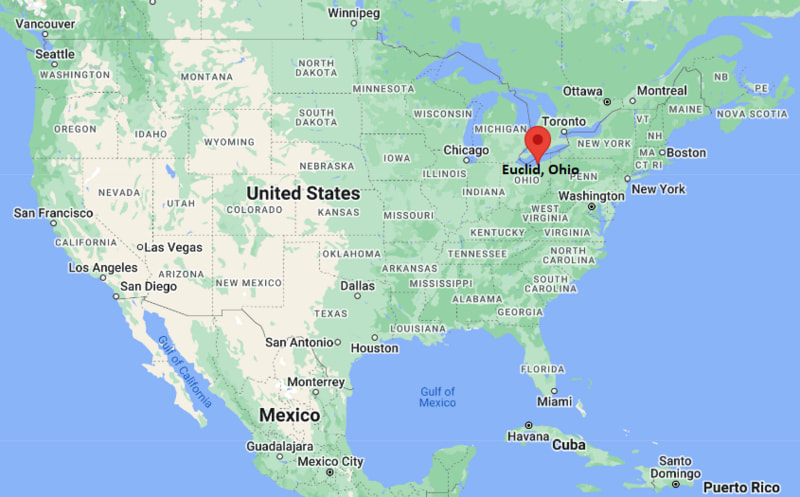
Euclid Map, Ohio, USA
Where is Euclid?: The Google Map showing the location of Euclid in the U.S. state of Ohio.
Where is Euclid Located?
Euclid is a city located in the Cuyahoga County of Ohio, United States. Euclid lies between 40.7139898 Degrees North latitudes and 73.5590157 Degrees West longitudes. According to 2020 U.S.census, the population of Euclid city is 49692 people and the city has a total area of 10.65 sq mi. The city has numerous parks and recreational facilities.
Most Viewed US Maps
| USA Sttae Map | USA Region Map | USA Road Map |
| USA County Map | Where is USA in World Map? | US ZIP Code Map |
| USA Time Zones Map | US State and Capitals Map | USA Physical Map |
Find 4,400+ U.S. Cities by State - Explore Their Locations and Get Detailed Information
Euclid, Ohio Quick Facts
| Property | Details |
|---|---|
| City | Euclid |
| County | Cuyahoga County |
| State | Ohio |
| State Capital | Columbus |
| US Region | Midwest |
| Latitude | 41.5931°N |
| Longitude | 81.5268°W |
| Elevation | ~620 ft (189 m) |
| Land Area | Approx. 10.5 sq mi |
| Water Area | Approx. 0.2 sq mi |
| Total Area | Approx. 10.7 sq mi |
| Population (2020 Census) | ~48,920 |
| Population Density | Approximately 4,600 per sq mi |
| ZIP Codes | 44117, 44119, 44123 |
| Area Code | 216 |
| Time Zone Standard | Eastern Standard Time (EST), UTC−5 |
| Time Zone Daylight | Eastern Daylight Time (EDT), UTC−4 |
| Currency | US Dollar (USD) |
| FIPS Code | 39-25840 |
| Congressional District | Ohio's 11th Congressional District |
Nearby Cities to Euclid, Ohio
- Cleveland, Ohio - West - 10 mi
- East Cleveland, Ohio - Southwest - 6 mi
- South Euclid, Ohio - South - 7 mi
- Richmond Heights, Ohio - Southeast - 5 mi
- Wickliffe, Ohio - East - 4 mi
- Willoughby, Ohio - East - 8 mi
- Lyndhurst, Ohio - South - 8 mi
- Mentor, Ohio - Northeast - 15 mi
- Lakewood, Ohio - West - 14 mi
- Parma, Ohio - Southwest - 18 mi
Euclid, Ohio Climate and Weather Overview
| Month | Avg High (°F) | Avg Low (°F) | Avg Rainfall (in) |
|---|---|---|---|
| January | 34 | 21 | 2.5 |
| April | 56 | 38 | 3.1 |
| July | 82 | 64 | 3.6 |
| October | 60 | 45 | 3.0 |
| Annual | 58 | 42 | 38.0 |
| Climate Attribute | Details |
|---|---|
| Climate Classification (Köppen) | Humid continental (Dfa) |
| Annual Rainfall | About 38 inches |
| Annual Snowfall | ~60–70 inches |
| Severe Weather Risk | Winter storms, occasional thunderstorms |
| Lake Effect Influence | Moderate (Lake Erie effect) |
Driving Distances from Euclid, Ohio
| City | State | Distance (mi) | Approx. Drive Time |
|---|---|---|---|
| Cleveland | Ohio | 10 | 15–20 min |
| East Cleveland | Ohio | 6 | 10–15 min |
| South Euclid | Ohio | 7 | 15 min |
| Wickliffe | Ohio | 4 | 10 min |
| Willoughby | Ohio | 8 | 15 min |
| Mentor | Ohio | 15 | 25 min |
| Lyndhurst | Ohio | 8 | 15–20 min |
| Lakewood | Ohio | 14 | 25 min |
| Parma | Ohio | 18 | 30 min |
| Akron | Ohio | 40 | 45–50 min |
Transportation and Connectivity in Euclid, Ohio
| Transportation | Details |
|---|---|
| Airport Name | Cleveland Hopkins International Airport |
| IATA Code | CLE |
| Port | Port of Cleveland (Lake Erie) |
| Major Highways | U.S. Route 20, I-90 (nearby), Ohio State Route 2 |
| Rail Service | Amtrak via Cleveland Lakefront Station (regional access) |
| Local Transit | Greater Cleveland RTA buses |
- Euclid is a lakeside suburb of Cleveland along the southern shore of Lake Erie.
- I-90 provides the main regional highway connection to downtown Cleveland and eastern Ohio.
- The city has a strong industrial history tied to manufacturing and lake shipping.
- Public transit connects Euclid to major employment and commercial centers across Cuyahoga County.
Places to Visit in Euclid, Ohio
| Landmark Name | Type |
|---|---|
| Euclid Beach Park Historical Site | Historic Amusement Park Site |
| Shore Cultural Centre | Cultural & Event Center |
| Euclid Creek Reservation | Metropark |
| Lakefront Reservation | Lakefront Park |
| Wildwood Park | Community Park |
| Memphis Kiddie Park | Amusement Park |
| Cleveland Museum of Art | Museum |
| Rock & Roll Hall of Fame | Museum |
| Edgewater Park | Lakefront Beach Park |
| Cleveland Metroparks Zoo | Zoo |
Colleges and Universities in Euclid, Ohio
| Institution Name | Type | Level | Notable For |
|---|---|---|---|
| Cleveland State University | Public | University | Law, business, urban studies |
| Case Western Reserve University | Private | University | Medicine, engineering, research |
| John Carroll University | Private | University | Liberal arts and business |
| Cuyahoga Community College (Tri-C) | Public | Community College | Workforce training and associate degrees |
| Baldwin Wallace University | Private | University | Music, business, education |
| Lakeland Community College | Public | Community College | Technical and transfer programs |
| Euclid City School District | Public | K–12 District | Primary and secondary education |
| Mentor Public Schools | Public | K–12 District | Regional education system |
Waterbodies in Euclid, Ohio
Lake Erie, Euclid Creek, Chagrin River (nearby), Doan Brook (regional), Arcola Creek, Big Creek (Cleveland watershed), Cuyahoga River (regional), Lakefront shoreline
Golf Courses in Euclid, Ohio
Manakiki Golf Course, Briardale Greens Golf Course, StoneWater Golf Club, Acacia Country Club, Highland Park Golf Course, Little Mountain Country Club, Mayfield Country Club, Sleepy Hollow Golf Course
Euclid, Ohio — Key Historical Facts
- Euclid was originally settled in the early 19th century and named after the Greek mathematician Euclid.
- The area developed as farmland before industrial expansion from nearby Cleveland transformed it into a suburb.
- In the early 20th century, Euclid became known for manufacturing and steel-related industries.
- Euclid Beach Park was once one of the most popular amusement destinations on Lake Erie.
- Post–World War II suburban growth significantly increased residential development.
- Today, Euclid is a diverse lakefront community with strong ties to Cleveland’s economy and cultural region.
References
Ohio More Maps & Info
- Where is Beavercreek
- Where is Bowling Green
- Where is Brunswick
- Where is Canton
- Where is Cleveland Heights
- Where is Cuyahoga Falls
- Where is Dayton
- Where is Delaware
- Where is Dublin
- Where is Elyria
- Where is Euclid
- Where is Fairborn
- Where is Fairfield
- Where is Findlay
- Where is Gahanna
- Where is Garfield Heights
- Where is Grove City
- Where is Hamilton
- Where is Hilliard
- Where is Huber Heights
- Where is Kettering
- Where is Lakewood
- Where is Lancaster
- Where is Lima
- Where is Lorain
- Where is Mansfield
- Where is Marion
- Where is Mason
- Where is Massillon
- Where is Mentor
- Where is Middletown
- Where is North Olmsted
- Where is North Ridgeville
- Where is North Royalton
- Where is Parma
- Where is Reynoldsburg
- Where is Stow
- Where is Strongsville
- Where is Upper Arlington
- Where is Warren
- Where is Westerville
- Where is Westlake
- Where is Youngstown