
Where is Gahanna Located? - Gahanna is a city located in the Franklin County of Ohio, United States. Gahanna lies between 40.8584316 Degrees North latitudes and 73.0995539 Degrees West longitudes.
Location Map of Gahanna, Ohio
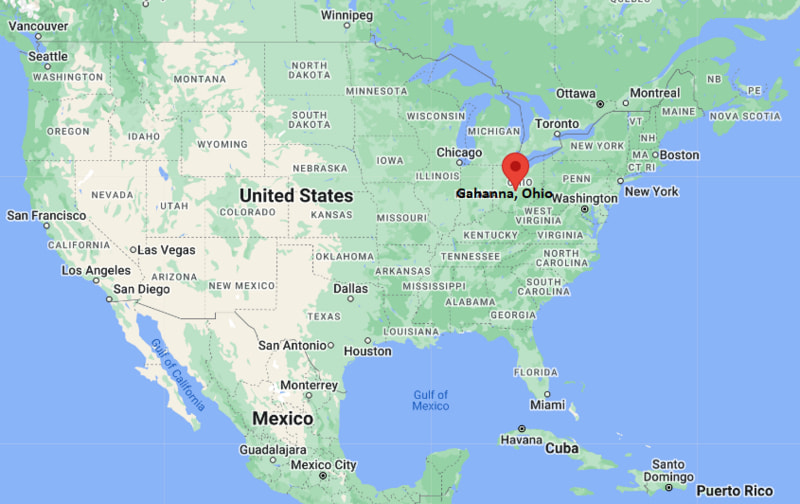
Gahanna Map, Ohio, USA
Where is Gahanna?: The Google Map showing the location of Gahanna in the U.S. state of Ohio.
Where is Gahanna Located?
Gahanna is a city located in the Franklin County of Ohio, United States. Gahanna lies between 40.8584316 Degrees North latitudes and 73.0995539 Degrees West longitudes. According to 2020 U.S.census, the population of Gahanna city is 35726 people and the city has a total area of 12.43 sq mi. The city has numerous parks and recreational facilities.
Most Viewed US Maps
| USA Sttae Map | USA Region Map | USA Road Map |
| USA County Map | Where is USA in World Map? | US ZIP Code Map |
| USA Time Zones Map | US State and Capitals Map | USA Physical Map |
Find 4,400+ U.S. Cities by State - Explore Their Locations and Get Detailed Information
Gahanna, Ohio Quick Facts
| Property | Information |
|---|---|
| City | Gahanna |
| County | Franklin County |
| State | Ohio |
| State Capital | Columbus |
| US Region | Midwest |
| Latitude | 40.0192°N |
| Longitude | 82.8793°W |
| Elevation | 810 ft (247 m) |
| Land Area | 12.53 sq mi |
| Water Area | 0.10 sq mi |
| Total Area | 12.63 sq mi |
| Population (2020 Census) | 35,297 |
| Population Density | 2,817 per sq mi |
| ZIP Codes | 43230, 43231 |
| Area Code | 380, 614 |
| Time Zone Standard | Eastern Standard Time (EST, UTC−5) |
| Time Zone Daylight | Eastern Daylight Time (EDT, UTC−4) |
| Currency | United States Dollar (USD) |
| FIPS Code | 39-29498 |
| Congressional District | Ohio's 3rd Congressional District |
Nearby Cities to Gahanna, Ohio
- New Albany, Ohio - Northeast - 7 mi
- Westerville, Ohio - North - 8 mi
- Columbus, Ohio - Southwest - 9 mi
- Whitehall, Ohio - South - 6 mi
- Reynoldsburg, Ohio - Southeast - 8 mi
- Bexley, Ohio - South - 9 mi
- Upper Arlington, Ohio - West - 15 mi
- Dublin, Ohio - Northwest - 18 mi
- Pickerington, Ohio - Southeast - 15 mi
- Grove City, Ohio - Southwest - 20 mi
Driving Distances from Gahanna, Ohio
| City | State | Distance (mi) | Approx. Drive Time |
|---|---|---|---|
| Whitehall | Ohio | 6 | 10 minutes |
| New Albany | Ohio | 7 | 12 minutes |
| Westerville | Ohio | 8 | 15 minutes |
| Reynoldsburg | Ohio | 8 | 15 minutes |
| Columbus | Ohio | 9 | 18 minutes |
| Bexley | Ohio | 9 | 18 minutes |
| Upper Arlington | Ohio | 15 | 25 minutes |
| Pickerington | Ohio | 15 | 25 minutes |
| Dublin | Ohio | 18 | 30 minutes |
| Grove City | Ohio | 20 | 35 minutes |
Transportation and Connectivity in Gahanna, Ohio
| Mode | Details |
|---|---|
| Airport Name | John Glenn Columbus International Airport |
| IATA Code | CMH |
| Port | Not Applicable |
| Major Highways | Interstate 270, Interstate 670, U.S. Route 62, State Route 161 |
| Train/Amtrak Service | Nearest Amtrak station is in Sandusky; Columbus has no Amtrak service |
| Local Bus/Transit Service | Central Ohio Transit Authority (COTA) |
- Interstate 270 forms the eastern beltway around Columbus and provides direct access to Gahanna.
- Interstate 670 connects the city with downtown Columbus and John Glenn Columbus International Airport.
- U.S. Route 62 passes through Gahanna, linking it with New Albany and central Columbus.
- State Route 161 provides convenient east-west travel across the northeastern Columbus metropolitan area.
What are top Places to Visit in Gahanna, Ohio
| Landmark Name | Type |
|---|---|
| Creekside Park & Plaza | Riverfront Park |
| Ohio Herb Education Center | Botanical & Education Center |
| Friendship Park | Community Park |
| Gahanna Woods State Nature Preserve | Nature Preserve |
| Hannah Park | City Park |
| Academy Park | Historic Park |
| Big Walnut Trail | Hiking & Biking Trail |
| Easton Town Center | Shopping & Entertainment District |
| Franklin Park Conservatory and Botanical Gardens | Botanical Garden |
| Blendon Woods Metro Park | Metro Park |
Colleges and Universities in Gahanna, Ohio
| Institution Name | Type | Level | Notable For |
|---|---|---|---|
| The Ohio State University | Public | University | Research, engineering, medicine, and business programs |
| Columbus State Community College | Public | Community College | Career training and university transfer programs |
| Otterbein University | Private | University | Liberal arts and professional studies |
| Capital University | Private | University | Law, music, and liberal arts education |
| Gahanna-Jefferson Public Schools | Public | K–12 District | Public education serving Gahanna |
Waterbodies in Gahanna, Ohio
Big Walnut Creek, Rocky Fork Creek, Alum Creek, Hoover Reservoir, Blacklick Creek, Scioto River, Griggs Reservoir, Big Walnut Creek Greenway
Golf Courses in Gahanna, Ohio
Jefferson Country Club, Champions Golf Course, Airport Golf Course, Little Turtle Golf Club, New Albany Links Golf Club, The Golf Club at Little Turtle
Gahanna, Ohio — Key Historical Facts
- Gahanna was founded in 1849 by John Clark, who named the community after a Native American word associated with three joining creeks.
- The city's early economy centered on farming, milling, and trade along Big Walnut Creek before expanding with improved transportation.
- Following World War II, Gahanna experienced rapid suburban growth as part of the expanding Columbus metropolitan area.
- The city became known as the "Herb Capital of Ohio" because of its focus on herb gardening, education, and annual cultural events.
- Today, Gahanna is recognized for its parks, trails, highly rated schools, thriving business community, and convenient location near John Glenn Columbus International Airport.
References
Ohio More Maps & Info
- Where is Beavercreek
- Where is Bowling Green
- Where is Brunswick
- Where is Canton
- Where is Cleveland Heights
- Where is Cuyahoga Falls
- Where is Dayton
- Where is Delaware
- Where is Dublin
- Where is Elyria
- Where is Euclid
- Where is Fairborn
- Where is Fairfield
- Where is Findlay
- Where is Gahanna
- Where is Garfield Heights
- Where is Grove City
- Where is Hamilton
- Where is Hilliard
- Where is Huber Heights
- Where is Kettering
- Where is Lakewood
- Where is Lancaster
- Where is Lima
- Where is Lorain
- Where is Mansfield
- Where is Marion
- Where is Mason
- Where is Massillon
- Where is Mentor
- Where is Middletown
- Where is North Olmsted
- Where is North Ridgeville
- Where is North Royalton
- Where is Parma
- Where is Reynoldsburg
- Where is Stow
- Where is Strongsville
- Where is Upper Arlington
- Where is Warren
- Where is Westerville
- Where is Westlake
- Where is Youngstown