Map of Franklin County - Franklin County is a county located in the U.S. state of Ohio. Franklin County Map showing cities, highways, important places and water bodies. Get Where is Franklin County located in the map, major cities in Franklin county, population, areas, and places of interest.
Map of Franklin County, Ohio
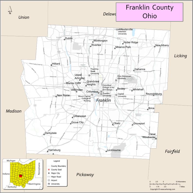
About Franklin County Map, Ohio: The map showing the county boundary, county seat, major cities, highways, water bodies and neighbouring counties.
Ohio More Maps & Info
About Franklin County, Ohio
Franklin County is a county located in the U.S. state of Ohio. It's county seat is Columbus. As per 2020 census, the population of Franklin County is 1321414 people and population density is square miles. According to the United States Census Bureau, the county has a total area of 539.87 sq mi (1,398 km2). Franklin County was established on -35308.
Franklin County Facts
| Continent | North America |
| Country | United States |
| State | Ohio |
| County Seat | Columbus |
| Largest City/Town | Columbus |
| Established | April 30, 1803 |
| Total Area | 544 sq mi (1,409 sq km) |
| Land Area | 532 sq mi (1,378 sq km) |
| Water Area | 12 sq mi (31 sq km) |
| Population | 1,323,807 (Census 2020) |
| Population Density | 2,488 people per sq mi |
| Time Zone | Eastern Time Zone (ET) |
| Major Highways | I-70, I-71, I-270, US-23, US-33, US-40, State Route 315 |
| Neighboring Counties | Delaware County, Licking County, Fairfield County, Pickaway County, Madison County, Union County |
| Famous For | Columbus, Ohio State University, government, business and cultural center |
| Top Attractions | Ohio Statehouse, Columbus Zoo, Franklin Park Conservatory, COSI |
| Official Website | https://commissioners.franklincountyohio.gov/ |
Cities and Towns in Franklin County, Ohio
- Columbus (county seat) – 905,748 (Census 2020)
- Dublin (partly) – 49,328 (Census 2020)
- Grove City – 41,252 (Census 2020)
- Westerville (partly) – 39,190 (Census 2020)
Roads and Highways in Franklin County, Ohio
Franklin County has a major highway network centered around Columbus, making it one of the most connected regions in Ohio.
- I-70 – east-west interstate connecting Columbus to Indianapolis and Pittsburgh
- I-71 – north-south interstate linking Cleveland, Columbus, and Cincinnati
- I-270 – outer beltway that circles Columbus and connects suburbs
- US-23 – runs north-south connecting Columbus to Toledo and southern Ohio
- US-33 – connects Columbus to Lancaster and southeastern Ohio
- US-40 – historic east-west route through Columbus
- State Route 315 – major route running through central Columbus
Neighboring Counties of Franklin County
- Delaware County (north)
- Licking County (east)
- Fairfield County (southeast)
- Pickaway County (south)
- Madison County (west)
- Union County (northwest)
Top Attractions in Franklin County, Ohio
Franklin County is a major cultural and entertainment hub with a wide range of attractions for visitors.
- Ohio Statehouse – historic government building in downtown Columbus
- Columbus Zoo and Aquarium – one of the top zoos in the United States
- Franklin Park Conservatory – botanical gardens with indoor and outdoor exhibits
- COSI (Center of Science and Industry) – interactive science museum
- German Village – historic neighborhood with shops and restaurants
- Scioto Mile – riverfront park system with trails and fountains
- Easton Town Center – large shopping and entertainment complex
- Ohio Stadium – home of Ohio State Buckeyes football
Distance from Franklin County to Nearby Cities
- Franklin County to Cleveland – 140 mi (225 km)
- Franklin County to Cincinnati – 105 mi (169 km)
- Franklin County to Dayton – 70 mi (113 km)
- Franklin County to Toledo – 135 mi (217 km)
- Franklin County to Pittsburgh – 185 mi (298 km)
FAQs about Franklin County
Franklin County is located in central Ohio and includes the state capital, Columbus.
It is known for Columbus, Ohio State University, and being a major economic and cultural center.
The population was 1,323,807 according to the 2020 Census.
Columbus is the largest city and also the county seat.
Major attractions include the Columbus Zoo, COSI, Franklin Park Conservatory, and Ohio Statehouse.
- Adams County Map
- Allen County Map
- Ashland County Map
- Ashtabula County Map
- Athens County Map
- Auglaize County Map
- Belmont County Map
- Brown County Map
- Butler County Map
- Carroll County Map
- Champaign County Map
- Clark County Map
- Clermont County Map
- Clinton County Map
- Columbiana County Map
- Coshocton County Map
- Crawford County Map
- Cuyahoga County Map
- Darke County Map
- Defiance County Map
- Delaware County Map
- Erie County Map
- Fairfield County Map
- Fayette County Map
- Franklin County Map
- Fulton County Map
- Gallia County Map
- Geauga County Map
- Greene County Map
- Guernsey County Map
- Hamilton County Map
- Hancock County Map
- Hardin County Map
- Harrison County Map
- Henry County Map
- Highland County Map
- Hocking County Map
- Holmes County Map
- Huron County Map
- Jackson County Map
- Jefferson County Map
- Knox County Map
- Lake County Map
- Lawrence County Map
- Licking County Map
- Logan County Map
- Lorain County Map
- Lucas County Map
- Madison County Map
- Mahoning County Map
- Marion County Map
- Medina County Map
- Meigs County Map
- Mercer County Map
- Miami County Map
- Monroe County Map
- Montgomery County Map
- Morgan County Map
- Morrow County Map
- Muskingum County Map
- Noble County Map
- Ottawa County Map
- Paulding County Map
- Perry County Map
- Pickaway County Map
- Pike County Map
- Portage County Map
- Preble County Map
- Putnam County Map
- Richland County Map
- Ross County Map
- Sandusky County Map
- Scioto County Map
- Seneca County Map
- Shelby County Map
- Stark County Map
- Summit County Map
- Trumbull County Map
- Tuscarawas County Map
- Union County Map
- Van Wert County Map
- Vinton County Map
- Warren County Map
- Washington County Map
- Wayne County Map
- Williams County Map
- Wood County Map
- Wyandot County Map
- Alabama Counties
- Alaska boroughs
- Arizona Counties
- Arkansas Counties
- California County Map
- Colorado Counties
- Connecticut Counties
- Delaware Counties
- Florida County Map
- Georgia County Map
- Hawaii Counties
- Idaho Counties
- Illinois Counties
- Indiana Counties
- Iowa Counties
- Kansas Counties
- Kentucky Counties
- Louisiana Counties
- Maine Counties
- Maryland Counties
- Massachusetts Counties
- Michigan County Map
- Minnesota Counties
- Mississippi Counties
- Missouri Counties
- Montana Counties
- Nebraska Counties
- Nevada Counties
- New York Counties
- New Hampshire Counties
- New Jersey Counties
- New Mexico Counties
- North Carolina Counties
- North Dakota Counties
- Ohio County Map
- Oklahoma Counties
- Oregon Counties
- Pennsylvania Counties
- Rhode Island Counties
- South Carolina Counties
- South Dakota Counties
- Map of Tennessee
- Texas County Map
- Utah Counties
- Vermont Counties
- Virginia Counties
- Washington Counties
- West Virginia Counties
- Wisconsin Counties
- Wyoming Counties