Map of Clermont County - Clermont County is a county located in the U.S. state of Ohio. Clermont County Map showing cities, highways, important places and water bodies. Get Where is Clermont County located in the map, major cities in Clermont county, population, areas, and places of interest.
Map of Clermont County, Ohio
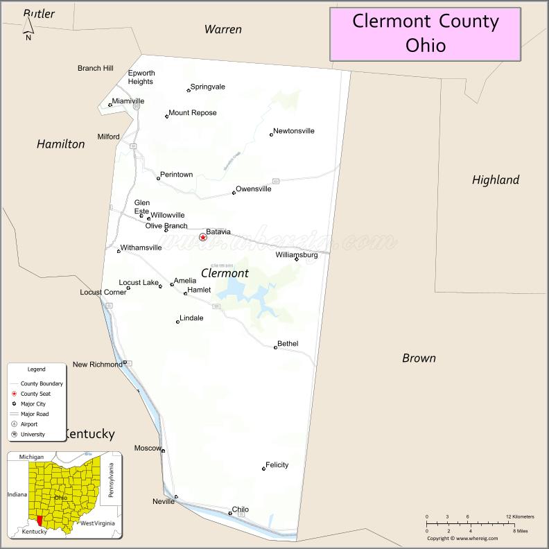
About Clermont County Map, Ohio: The map showing the county boundary, county seat, major cities, highways, water bodies and neighbouring counties.
Ohio More Maps & Info
About Clermont County, Ohio
Clermont County is a county located in the U.S. state of Ohio. It's county seat is Batavia. As per 2020 census, the population of Clermont County is 209642 people and population density is square miles. According to the United States Census Bureau, the county has a total area of 451.99 sq mi (1,171 km2). Clermont County was established on -36183.
Clermont County Facts
| Continent | North America |
| Country | United States |
| State | Ohio |
| County Seat | Batavia |
| Largest City/Town | Milford |
| Established | 1800 |
| Total Area | 460 sq mi |
| Land Area | 452 sq mi |
| Water Area | 8 sq mi |
| Population | 208,601 (Census 2020) |
| Population Density | 461 people per sq mi |
| Time Zone | Eastern Time Zone (ET) |
| Major Highways | I-275, US-50, SR-32, SR-125 |
| Neighboring Counties | Hamilton County, Brown County, Clinton County, Warren County, Campbell County (KY), Pendleton County (KY) |
| Famous For | Ohio River views, parks, historic sites |
| Top Attractions | East Fork State Park, Cincinnati Nature Center, Ohio River Scenic Byway |
| Official Website | https://www.clermontcountyohio.gov |
Cities and Towns in Clermont County, Ohio
- Batavia (county seat) – 1,509 (Census 2020)
- Milford – 6,582 (Census 2020)
- Loveland (partly in county) – 13,145 (Census 2020)
- Amelia – 5,421 (Census 2020)
Roads and Highways in Clermont County, Ohio
Clermont County is well connected by major highways that link it to Cincinnati and surrounding regions in Ohio and Kentucky.
- Interstate 275 (I-275) – beltway connecting the county to Cincinnati and northern Kentucky
- US Highway 50 – runs east-west connecting Milford to Cincinnati (west) and Hillsboro (east)
- State Route 32 – major east-west route connecting Batavia to Cincinnati (west) and Appalachian Ohio (east)
- State Route 125 – connects Amelia to Cincinnati (west) and Shawnee State Forest region (east)
Neighboring Counties of Clermont County
- Warren County (north)
- Clinton County (northeast)
- Brown County (east)
- Hamilton County (west)
- Campbell County, Kentucky (south)
- Pendleton County, Kentucky (south)
Top Attractions in Clermont County, Ohio
Clermont County offers scenic parks, nature preserves, and outdoor activities close to Cincinnati.
- East Fork State Park – one of Ohio’s largest state parks with hiking, boating, and camping
- Cincinnati Nature Center – popular for trails, wildlife, and outdoor education
- Ohio River Scenic Byway – beautiful drive along the river with small towns and views
- Loveland Castle – unique historic-style castle overlooking the Little Miami River
- Stonelick State Park – quiet park with a lake, camping, and fishing opportunities
- Promont House Museum – historic home offering insight into local history
- Little Miami Scenic Trail – paved trail ideal for biking and walking
- Grant Birthplace (nearby) – historic site tied to President Ulysses S. Grant
Distance from Clermont County to Nearby Cities
- Batavia to Cincinnati – 25 mi (40 km)
- Batavia to Dayton – 60 mi (97 km)
- Batavia to Columbus – 100 mi (161 km)
- Batavia to Lexington – 90 mi (145 km)
- Batavia to Louisville – 110 mi (177 km)
FAQs about Clermont County
Clermont County is located in southwestern Ohio along the Ohio River, just east of Cincinnati.
It is known for its scenic river views, parks, and historic attractions.
The population was 208,601 according to the 2020 Census.
The county seat is Batavia.
Top attractions include East Fork State Park, Cincinnati Nature Center, and the Ohio River Scenic Byway.
- Adams County Map
- Allen County Map
- Ashland County Map
- Ashtabula County Map
- Athens County Map
- Auglaize County Map
- Belmont County Map
- Brown County Map
- Butler County Map
- Carroll County Map
- Champaign County Map
- Clark County Map
- Clermont County Map
- Clinton County Map
- Columbiana County Map
- Coshocton County Map
- Crawford County Map
- Cuyahoga County Map
- Darke County Map
- Defiance County Map
- Delaware County Map
- Erie County Map
- Fairfield County Map
- Fayette County Map
- Franklin County Map
- Fulton County Map
- Gallia County Map
- Geauga County Map
- Greene County Map
- Guernsey County Map
- Hamilton County Map
- Hancock County Map
- Hardin County Map
- Harrison County Map
- Henry County Map
- Highland County Map
- Hocking County Map
- Holmes County Map
- Huron County Map
- Jackson County Map
- Jefferson County Map
- Knox County Map
- Lake County Map
- Lawrence County Map
- Licking County Map
- Logan County Map
- Lorain County Map
- Lucas County Map
- Madison County Map
- Mahoning County Map
- Marion County Map
- Medina County Map
- Meigs County Map
- Mercer County Map
- Miami County Map
- Monroe County Map
- Montgomery County Map
- Morgan County Map
- Morrow County Map
- Muskingum County Map
- Noble County Map
- Ottawa County Map
- Paulding County Map
- Perry County Map
- Pickaway County Map
- Pike County Map
- Portage County Map
- Preble County Map
- Putnam County Map
- Richland County Map
- Ross County Map
- Sandusky County Map
- Scioto County Map
- Seneca County Map
- Shelby County Map
- Stark County Map
- Summit County Map
- Trumbull County Map
- Tuscarawas County Map
- Union County Map
- Van Wert County Map
- Vinton County Map
- Warren County Map
- Washington County Map
- Wayne County Map
- Williams County Map
- Wood County Map
- Wyandot County Map
- Alabama Counties
- Alaska boroughs
- Arizona Counties
- Arkansas Counties
- California County Map
- Colorado Counties
- Connecticut Counties
- Delaware Counties
- Florida County Map
- Georgia County Map
- Hawaii Counties
- Idaho Counties
- Illinois Counties
- Indiana Counties
- Iowa Counties
- Kansas Counties
- Kentucky Counties
- Louisiana Counties
- Maine Counties
- Maryland Counties
- Massachusetts Counties
- Michigan County Map
- Minnesota Counties
- Mississippi Counties
- Missouri Counties
- Montana Counties
- Nebraska Counties
- Nevada Counties
- New York Counties
- New Hampshire Counties
- New Jersey Counties
- New Mexico Counties
- North Carolina Counties
- North Dakota Counties
- Ohio County Map
- Oklahoma Counties
- Oregon Counties
- Pennsylvania Counties
- Rhode Island Counties
- South Carolina Counties
- South Dakota Counties
- Map of Tennessee
- Texas County Map
- Utah Counties
- Vermont Counties
- Virginia Counties
- Washington Counties
- West Virginia Counties
- Wisconsin Counties
- Wyoming Counties