Map of Geauga County - Geauga County is a county located in the U.S. state of Ohio. Geauga County Map showing cities, highways, important places and water bodies. Get Where is Geauga County located in the map, major cities in Geauga county, population, areas, and places of interest.
Map of Geauga County, Ohio
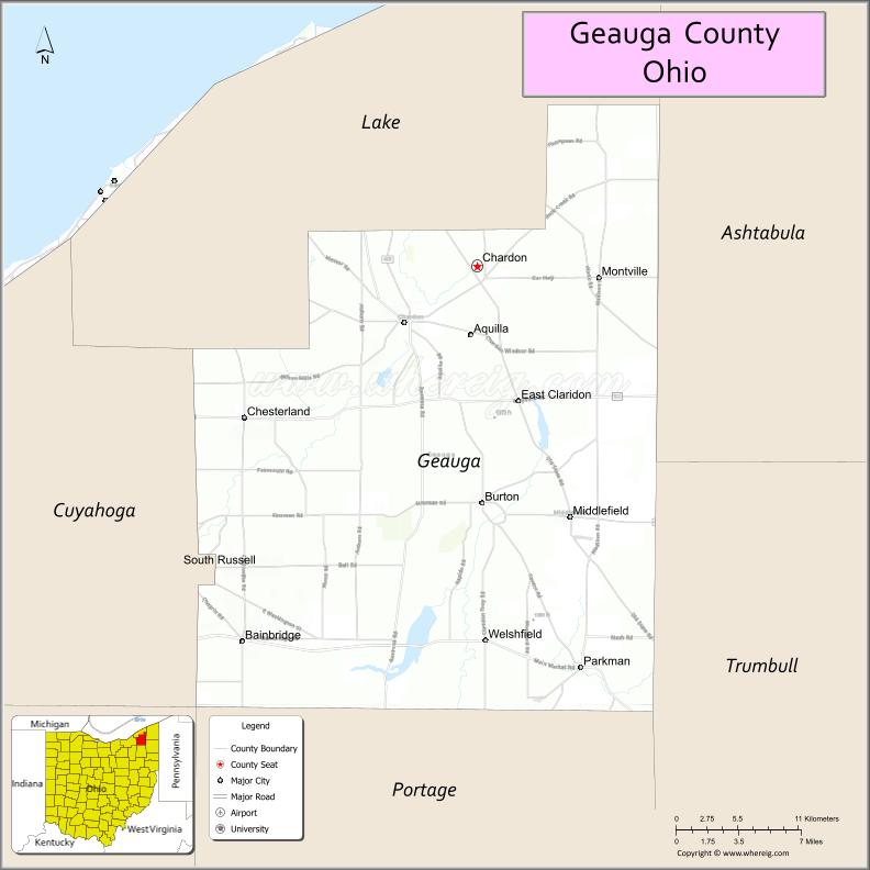
About Geauga County Map, Ohio: The map showing the county boundary, county seat, major cities, highways, water bodies and neighbouring counties.
Ohio More Maps & Info
About Geauga County, Ohio
Geauga County is a county located in the U.S. state of Ohio. It's county seat is Chardon. As per 2020 census, the population of Geauga County is 95565 people and population density is square miles. According to the United States Census Bureau, the county has a total area of 403.66 sq mi (1,045 km2). Geauga County was established on -34272.
Geauga County Facts
| Continent | North America |
| Country | United States |
| State | Ohio |
| County Seat | Chardon |
| Largest City/Town | Chardon |
| Established | March 1, 1806 |
| Total Area | 408 sq mi (1,057 sq km) |
| Land Area | 400 sq mi (1,036 sq km) |
| Water Area | 8.0 sq mi (20.7 sq km) |
| Population | 95,397 (Census 2020) |
| Population Density | 239 people per sq mi |
| Time Zone | Eastern Time Zone (ET) |
| Major Highways | US-6, US-322, State Route 44, State Route 87, State Route 88 |
| Neighboring Counties | Lake County, Ashtabula County, Trumbull County, Portage County, Cuyahoga County |
| Famous For | Amish community, maple syrup production, rural landscapes |
| Top Attractions | Punderson State Park, Observatory Park, Century Village Museum, Amish Country |
| Official Website | https://co.geauga.oh.us/ |
Cities and Towns in Geauga County, Ohio
- Chardon (county seat) – 5,242 (Census 2020)
- Burton – 1,452 (Census 2020)
- Middlefield – 2,694 (Census 2020)
- South Russell – 3,810 (Census 2020)
Roads and Highways in Geauga County, Ohio
Geauga County is served by several highways that connect it to the Cleveland area and northeastern Ohio.
- US-6 – east-west route connecting the county to Lake County and Ashtabula
- US-322 – major route linking Cleveland to Warren through the county
- State Route 44 – north-south highway connecting Lake County to Portage County
- State Route 87 – runs east-west across rural parts of the county
- State Route 88 – connects Chardon to Garrettsville and surrounding communities
Neighboring Counties of Geauga County
- Lake County (north)
- Ashtabula County (northeast)
- Trumbull County (southeast)
- Portage County (south)
- Cuyahoga County (west)
Top Attractions in Geauga County, Ohio
Geauga County offers scenic countryside, outdoor parks, and a strong Amish heritage.
- Punderson State Park – popular for camping, fishing, and hiking
- Observatory Park – dark-sky park ideal for stargazing
- Century Village Museum – historic village with preserved buildings
- Geauga Amish Country – known for handmade goods and traditional lifestyle
- Big Creek Park – nature park with trails and wildlife viewing
- Swine Creek Reservation – scenic park with wetlands and walking paths
- Maple Festival in Chardon – annual event celebrating maple syrup production
- Chardon Square – historic downtown area with shops and dining
Distance from Geauga County to Nearby Cities
- Geauga County to Cleveland – 30 mi (48 km)
- Geauga County to Akron – 40 mi (64 km)
- Geauga County to Youngstown – 55 mi (89 km)
- Geauga County to Erie – 100 mi (161 km)
- Geauga County to Columbus – 150 mi (241 km)
FAQs about Geauga County
Geauga County is located in northeastern Ohio, east of Cleveland.
It is known for its Amish community, maple syrup production, and rural scenery.
The population was 95,397 according to the 2020 Census.
The county seat is Chardon.
Yes, the county has several parks including Punderson State Park and Observatory Park.
- Adams County Map
- Allen County Map
- Ashland County Map
- Ashtabula County Map
- Athens County Map
- Auglaize County Map
- Belmont County Map
- Brown County Map
- Butler County Map
- Carroll County Map
- Champaign County Map
- Clark County Map
- Clermont County Map
- Clinton County Map
- Columbiana County Map
- Coshocton County Map
- Crawford County Map
- Cuyahoga County Map
- Darke County Map
- Defiance County Map
- Delaware County Map
- Erie County Map
- Fairfield County Map
- Fayette County Map
- Franklin County Map
- Fulton County Map
- Gallia County Map
- Geauga County Map
- Greene County Map
- Guernsey County Map
- Hamilton County Map
- Hancock County Map
- Hardin County Map
- Harrison County Map
- Henry County Map
- Highland County Map
- Hocking County Map
- Holmes County Map
- Huron County Map
- Jackson County Map
- Jefferson County Map
- Knox County Map
- Lake County Map
- Lawrence County Map
- Licking County Map
- Logan County Map
- Lorain County Map
- Lucas County Map
- Madison County Map
- Mahoning County Map
- Marion County Map
- Medina County Map
- Meigs County Map
- Mercer County Map
- Miami County Map
- Monroe County Map
- Montgomery County Map
- Morgan County Map
- Morrow County Map
- Muskingum County Map
- Noble County Map
- Ottawa County Map
- Paulding County Map
- Perry County Map
- Pickaway County Map
- Pike County Map
- Portage County Map
- Preble County Map
- Putnam County Map
- Richland County Map
- Ross County Map
- Sandusky County Map
- Scioto County Map
- Seneca County Map
- Shelby County Map
- Stark County Map
- Summit County Map
- Trumbull County Map
- Tuscarawas County Map
- Union County Map
- Van Wert County Map
- Vinton County Map
- Warren County Map
- Washington County Map
- Wayne County Map
- Williams County Map
- Wood County Map
- Wyandot County Map
- Alabama Counties
- Alaska boroughs
- Arizona Counties
- Arkansas Counties
- California County Map
- Colorado Counties
- Connecticut Counties
- Delaware Counties
- Florida County Map
- Georgia County Map
- Hawaii Counties
- Idaho Counties
- Illinois Counties
- Indiana Counties
- Iowa Counties
- Kansas Counties
- Kentucky Counties
- Louisiana Counties
- Maine Counties
- Maryland Counties
- Massachusetts Counties
- Michigan County Map
- Minnesota Counties
- Mississippi Counties
- Missouri Counties
- Montana Counties
- Nebraska Counties
- Nevada Counties
- New York Counties
- New Hampshire Counties
- New Jersey Counties
- New Mexico Counties
- North Carolina Counties
- North Dakota Counties
- Ohio County Map
- Oklahoma Counties
- Oregon Counties
- Pennsylvania Counties
- Rhode Island Counties
- South Carolina Counties
- South Dakota Counties
- Map of Tennessee
- Texas County Map
- Utah Counties
- Vermont Counties
- Virginia Counties
- Washington Counties
- West Virginia Counties
- Wisconsin Counties
- Wyoming Counties