Map of Champaign County - Champaign County is a county located in the U.S. state of Ohio. Champaign County Map showing cities, highways, important places and water bodies. Get Where is Champaign County located in the map, major cities in Champaign county, population, areas, and places of interest.
Map of Champaign County, Ohio
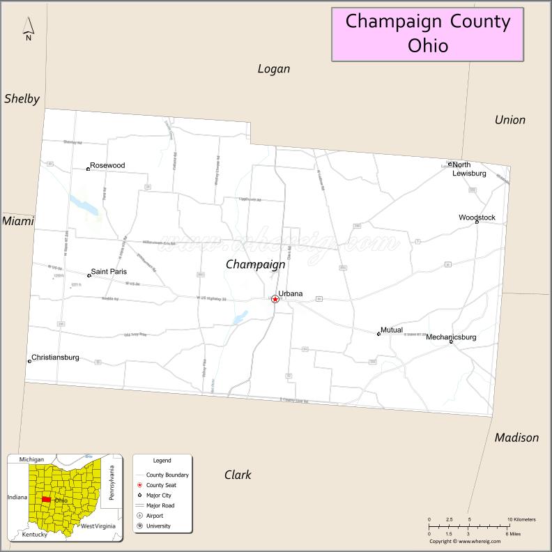
About Champaign County Map, Ohio: The map showing the county boundary, county seat, major cities, highways, water bodies and neighbouring counties.
Ohio More Maps & Info
About Champaign County, Ohio
Champaign County is a county located in the U.S. state of Ohio. It's county seat is Urbana. As per 2020 census, the population of Champaign County is 38699 people and population density is square miles. According to the United States Census Bureau, the county has a total area of 428.56 sq mi (1,110 km2). Champaign County was established on -34637.
Champaign County Facts
| Continent | North America |
| Country | United States |
| State | Ohio |
| County Seat | Urbana |
| Largest City/Town | Urbana |
| Established | 1805 |
| Total Area | 430 sq mi |
| Land Area | 429 sq mi |
| Water Area | 1 sq mi |
| Population | 38,714 (Census 2020) |
| Population Density | 90 people per sq mi |
| Time Zone | Eastern Time Zone (ET) |
| Major Highways | US-68, US-36, SR-29, SR-55 |
| Neighboring Counties | Logan County, Union County, Madison County, Clark County, Miami County, Shelby County |
| Famous For | Agriculture, historic small towns, aviation heritage |
| Top Attractions | Grimes Field Aviation Museum, Cedar Bog Nature Preserve, Champaign Aviation Museum |
| Official Website | https://www.co.champaign.oh.us |
Cities and Towns in Champaign County, Ohio
- Urbana (county seat) – 11,613 (Census 2020)
- St. Paris – 2,089 (Census 2020)
- Mechanicsburg – 1,644 (Census 2020)
- North Lewisburg – 1,490 (Census 2020)
Roads and Highways in Champaign County, Ohio
Champaign County is connected by key highways that link it to Dayton, Columbus, and surrounding rural areas.
- US Highway 68 – runs north-south connecting Urbana to Springfield (south) and Bellefontaine (north)
- US Highway 36 – runs east-west connecting Urbana to Columbus (east) and Piqua (west)
- State Route 29 – connects Urbana to Sidney (northwest) and London (southeast)
- State Route 55 – runs north-south connecting Mechanicsburg to Troy (north) and Springfield (south)
Neighboring Counties of Champaign County
- Logan County (north)
- Shelby County (northwest)
- Miami County (west)
- Clark County (south)
- Madison County (south)
- Union County (east)
Top Attractions in Champaign County, Ohio
Champaign County offers a mix of outdoor nature, aviation history, and quiet small-town charm.
- Grimes Field Aviation Museum – showcases vintage aircraft and aviation history
- Champaign Aviation Museum – home to a B-17 restoration project
- Cedar Bog Nature Preserve – unique wetland area with rare plants and wildlife
- Simon Kenton Trail – scenic trail for biking and walking
- Urbana Historic Downtown – features local shops, dining, and historic buildings
- Melvin Miller Park – community park with trails and open green space
- Kiser Lake State Park (nearby) – popular for fishing, boating, and camping
- St. Paris Public Square – charming small-town gathering place
Distance from Champaign County to Nearby Cities
- Urbana to Columbus – 50 mi (80 km)
- Urbana to Dayton – 40 mi (64 km)
- Urbana to Springfield – 15 mi (24 km)
- Urbana to Cincinnati – 95 mi (153 km)
- Urbana to Toledo – 130 mi (209 km)
FAQs about Champaign County
Champaign County is located in west-central Ohio between Columbus and Dayton.
It is known for its agricultural heritage, aviation museums, and small-town communities.
The population was 38,714 according to the 2020 Census.
The county seat is Urbana.
Top attractions include Grimes Field Aviation Museum, Cedar Bog Nature Preserve, and Champaign Aviation Museum.
- Adams County Map
- Allen County Map
- Ashland County Map
- Ashtabula County Map
- Athens County Map
- Auglaize County Map
- Belmont County Map
- Brown County Map
- Butler County Map
- Carroll County Map
- Champaign County Map
- Clark County Map
- Clermont County Map
- Clinton County Map
- Columbiana County Map
- Coshocton County Map
- Crawford County Map
- Cuyahoga County Map
- Darke County Map
- Defiance County Map
- Delaware County Map
- Erie County Map
- Fairfield County Map
- Fayette County Map
- Franklin County Map
- Fulton County Map
- Gallia County Map
- Geauga County Map
- Greene County Map
- Guernsey County Map
- Hamilton County Map
- Hancock County Map
- Hardin County Map
- Harrison County Map
- Henry County Map
- Highland County Map
- Hocking County Map
- Holmes County Map
- Huron County Map
- Jackson County Map
- Jefferson County Map
- Knox County Map
- Lake County Map
- Lawrence County Map
- Licking County Map
- Logan County Map
- Lorain County Map
- Lucas County Map
- Madison County Map
- Mahoning County Map
- Marion County Map
- Medina County Map
- Meigs County Map
- Mercer County Map
- Miami County Map
- Monroe County Map
- Montgomery County Map
- Morgan County Map
- Morrow County Map
- Muskingum County Map
- Noble County Map
- Ottawa County Map
- Paulding County Map
- Perry County Map
- Pickaway County Map
- Pike County Map
- Portage County Map
- Preble County Map
- Putnam County Map
- Richland County Map
- Ross County Map
- Sandusky County Map
- Scioto County Map
- Seneca County Map
- Shelby County Map
- Stark County Map
- Summit County Map
- Trumbull County Map
- Tuscarawas County Map
- Union County Map
- Van Wert County Map
- Vinton County Map
- Warren County Map
- Washington County Map
- Wayne County Map
- Williams County Map
- Wood County Map
- Wyandot County Map
- Alabama Counties
- Alaska boroughs
- Arizona Counties
- Arkansas Counties
- California County Map
- Colorado Counties
- Connecticut Counties
- Delaware Counties
- Florida County Map
- Georgia County Map
- Hawaii Counties
- Idaho Counties
- Illinois Counties
- Indiana Counties
- Iowa Counties
- Kansas Counties
- Kentucky Counties
- Louisiana Counties
- Maine Counties
- Maryland Counties
- Massachusetts Counties
- Michigan County Map
- Minnesota Counties
- Mississippi Counties
- Missouri Counties
- Montana Counties
- Nebraska Counties
- Nevada Counties
- New York Counties
- New Hampshire Counties
- New Jersey Counties
- New Mexico Counties
- North Carolina Counties
- North Dakota Counties
- Ohio County Map
- Oklahoma Counties
- Oregon Counties
- Pennsylvania Counties
- Rhode Island Counties
- South Carolina Counties
- South Dakota Counties
- Map of Tennessee
- Texas County Map
- Utah Counties
- Vermont Counties
- Virginia Counties
- Washington Counties
- West Virginia Counties
- Wisconsin Counties
- Wyoming Counties