Map of Henry County - Henry County is a county located in the U.S. state of Ohio. Henry County Map showing cities, highways, important places and water bodies. Get Where is Henry County located in the map, major cities in Henry county, population, areas, and places of interest.
Map of Henry County, Ohio
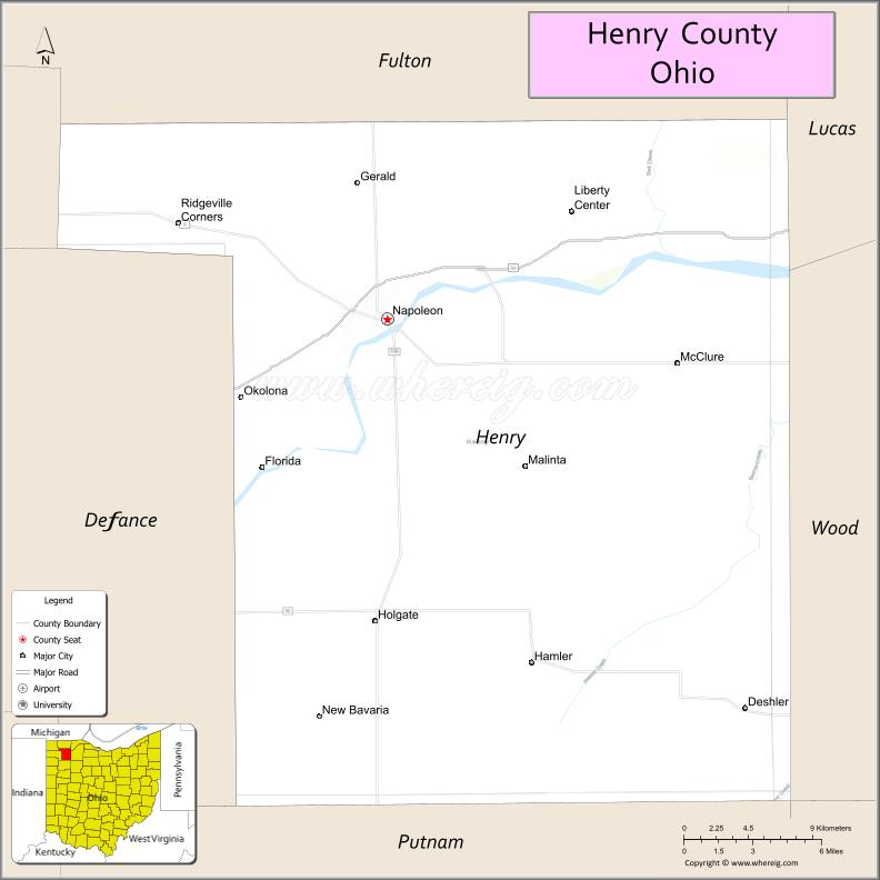
About Henry County Map, Ohio: The map showing the county boundary, county seat, major cities, highways, water bodies and neighbouring counties.
Ohio More Maps & Info
About Henry County, Ohio
Henry County is a county located in the U.S. state of Ohio. It's county seat is Napoleon. As per 2020 census, the population of Henry County is 27538 people and population density is square miles. According to the United States Census Bureau, the county has a total area of 416.50 sq mi (1,079 km2). Henry County was established on -29127.
Henry County Facts
| Continent | North America |
| Country | United States |
| State | Ohio |
| County Seat | Napoleon |
| Largest City/Town | Napoleon |
| Established | April 1, 1820 |
| Total Area | 420 sq mi (1,088 sq km) |
| Land Area | 416 sq mi (1,077 sq km) |
| Water Area | 3.7 sq mi (9.6 sq km) |
| Population | 27,825 (Census 2020) |
| Population Density | 67 people per sq mi |
| Time Zone | Eastern Time Zone (ET) |
| Major Highways | US-24, State Route 108, State Route 109, State Route 110, State Route 281 |
| Neighboring Counties | Fulton County, Lucas County, Wood County, Putnam County, Defiance County, Williams County |
| Famous For | Maumee River, agriculture, Campbell Soup Company plant |
| Top Attractions | Oak Openings access, Harrison Lake State Park, Napoleon Historic District, Maumee River |
| Official Website | https://henrycountyohio.gov/ |
Cities and Towns in Henry County, Ohio
- Napoleon (county seat) – 8,749 (Census 2020)
- Deshler – 1,710 (Census 2020)
- Holgate – 1,089 (Census 2020)
- McClure – 700 (Census 2020)
Roads and Highways in Henry County, Ohio
Henry County is connected by key highways that support travel across northwest Ohio and along the Maumee River corridor.
- US-24 – major east-west highway connecting Toledo to Fort Wayne through Napoleon
- State Route 108 – runs north-south linking Wauseon to Findlay
- State Route 109 – connects Liberty Center to Delta through the county
- State Route 110 – east-west route linking Napoleon to Wood County and Defiance
- State Route 281 – runs through rural parts of the county connecting small communities
Neighboring Counties of Henry County
- Fulton County (north)
- Lucas County (northeast)
- Wood County (east)
- Putnam County (south)
- Defiance County (west)
- Williams County (northwest)
Top Attractions in Henry County, Ohio
Henry County offers scenic river views, parks, and small-town charm.
- Harrison Lake State Park – popular for camping, fishing, and boating
- Maumee River – scenic waterway for kayaking and fishing
- Napoleon Historic District – downtown area with historic buildings and shops
- Oak Openings region access – nearby natural area with trails and wildlife
- Goll Woods State Nature Preserve – old-growth forest with walking trails
- Deshler Railfan Park – popular spot for watching trains
- Holgate Community Park – local park with recreational facilities
- Henry County Fairgrounds – hosts local events and annual fair
Distance from Henry County to Nearby Cities
- Henry County to Toledo – 40 mi (64 km)
- Henry County to Fort Wayne – 65 mi (105 km)
- Henry County to Findlay – 30 mi (48 km)
- Henry County to Lima – 55 mi (89 km)
- Henry County to Columbus – 130 mi (209 km)
FAQs about Henry County
Henry County is located in northwestern Ohio.
It is known for the Maumee River, agriculture, and local industry.
The population was 27,825 according to the 2020 Census.
The county seat is Napoleon.
Yes, the county has parks, a state park, and river-based activities.
- Adams County Map
- Allen County Map
- Ashland County Map
- Ashtabula County Map
- Athens County Map
- Auglaize County Map
- Belmont County Map
- Brown County Map
- Butler County Map
- Carroll County Map
- Champaign County Map
- Clark County Map
- Clermont County Map
- Clinton County Map
- Columbiana County Map
- Coshocton County Map
- Crawford County Map
- Cuyahoga County Map
- Darke County Map
- Defiance County Map
- Delaware County Map
- Erie County Map
- Fairfield County Map
- Fayette County Map
- Franklin County Map
- Fulton County Map
- Gallia County Map
- Geauga County Map
- Greene County Map
- Guernsey County Map
- Hamilton County Map
- Hancock County Map
- Hardin County Map
- Harrison County Map
- Henry County Map
- Highland County Map
- Hocking County Map
- Holmes County Map
- Huron County Map
- Jackson County Map
- Jefferson County Map
- Knox County Map
- Lake County Map
- Lawrence County Map
- Licking County Map
- Logan County Map
- Lorain County Map
- Lucas County Map
- Madison County Map
- Mahoning County Map
- Marion County Map
- Medina County Map
- Meigs County Map
- Mercer County Map
- Miami County Map
- Monroe County Map
- Montgomery County Map
- Morgan County Map
- Morrow County Map
- Muskingum County Map
- Noble County Map
- Ottawa County Map
- Paulding County Map
- Perry County Map
- Pickaway County Map
- Pike County Map
- Portage County Map
- Preble County Map
- Putnam County Map
- Richland County Map
- Ross County Map
- Sandusky County Map
- Scioto County Map
- Seneca County Map
- Shelby County Map
- Stark County Map
- Summit County Map
- Trumbull County Map
- Tuscarawas County Map
- Union County Map
- Van Wert County Map
- Vinton County Map
- Warren County Map
- Washington County Map
- Wayne County Map
- Williams County Map
- Wood County Map
- Wyandot County Map
- Alabama Counties
- Alaska boroughs
- Arizona Counties
- Arkansas Counties
- California County Map
- Colorado Counties
- Connecticut Counties
- Delaware Counties
- Florida County Map
- Georgia County Map
- Hawaii Counties
- Idaho Counties
- Illinois Counties
- Indiana Counties
- Iowa Counties
- Kansas Counties
- Kentucky Counties
- Louisiana Counties
- Maine Counties
- Maryland Counties
- Massachusetts Counties
- Michigan County Map
- Minnesota Counties
- Mississippi Counties
- Missouri Counties
- Montana Counties
- Nebraska Counties
- Nevada Counties
- New York Counties
- New Hampshire Counties
- New Jersey Counties
- New Mexico Counties
- North Carolina Counties
- North Dakota Counties
- Ohio County Map
- Oklahoma Counties
- Oregon Counties
- Pennsylvania Counties
- Rhode Island Counties
- South Carolina Counties
- South Dakota Counties
- Map of Tennessee
- Texas County Map
- Utah Counties
- Vermont Counties
- Virginia Counties
- Washington Counties
- West Virginia Counties
- Wisconsin Counties
- Wyoming Counties