Map of Carroll County - Carroll County is a county located in the U.S. state of Ohio. Carroll County Map showing cities, highways, important places and water bodies. Get Where is Carroll County located in the map, major cities in Carroll county, population, areas, and places of interest.
Map of Carroll County, Ohio
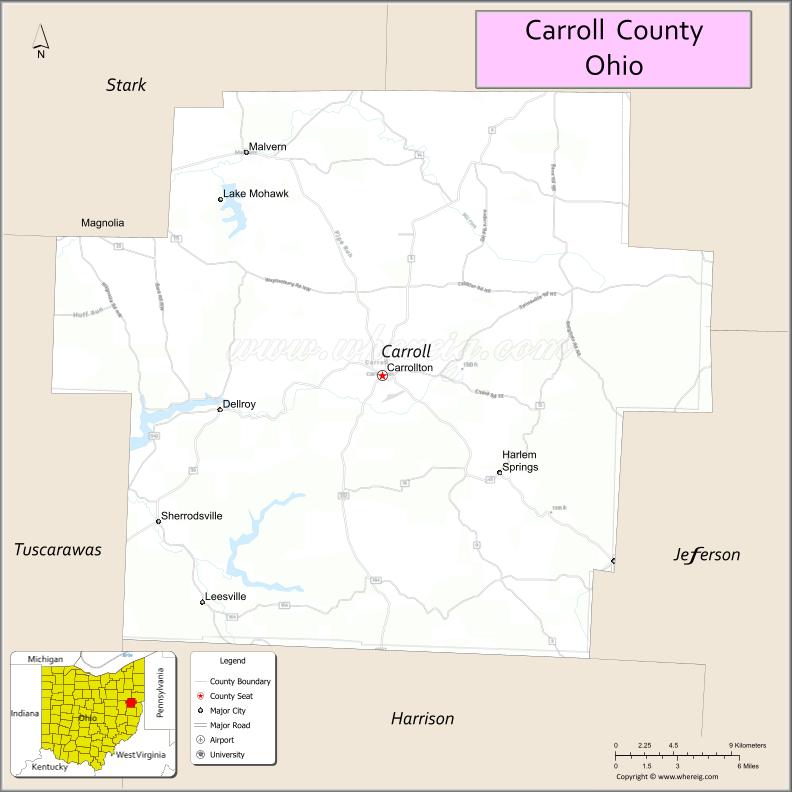
About Carroll County Map, Ohio: The map showing the county boundary, county seat, major cities, highways, water bodies and neighbouring counties.
Ohio More Maps & Info
About Carroll County, Ohio
Carroll County is a county located in the U.S. state of Ohio. It's county seat is Carrollton. As per 2020 census, the population of Carroll County is 26691 people and population density is square miles. According to the United States Census Bureau, the county has a total area of 394.67 sq mi (1,022 km2). Carroll County was established on -24469.
Carroll County Facts
| Continent | North America |
| Country | United States |
| State | Ohio |
| County Seat | Carrollton |
| Largest City/Town | Carrollton |
| Established | 1832 |
| Total Area | 399 sq mi |
| Land Area | 395 sq mi |
| Water Area | 4 sq mi |
| Population | 26,914 (Census 2020) |
| Population Density | 68 people per sq mi |
| Time Zone | Eastern Time Zone (ET) |
| Major Highways | SR-9, SR-39, SR-43, SR-171 |
| Neighboring Counties | Stark County, Columbiana County, Jefferson County, Harrison County, Tuscarawas County |
| Famous For | Amish communities, rural scenery, Atwood Lake |
| Top Attractions | Atwood Lake Park, Algonquin Mill, Carroll County Courthouse |
| Official Website | https://www.carrollcountyohio.us |
Cities and Towns in Carroll County, Ohio
- Carrollton (county seat) – 3,241 (Census 2020)
- Dellroy – 269 (Census 2020)
- Sherrodsville – 304 (Census 2020)
- Leesville – 160 (Census 2020)
Roads and Highways in Carroll County, Ohio
Carroll County is served by state highways that connect small towns with nearby regional centers in eastern Ohio.
- State Route 9 – runs north-south connecting Carrollton to Cadiz (south) and Salem (north)
- State Route 39 – runs east-west connecting Carrollton to New Philadelphia (west) and Wellsville (east)
- State Route 43 – connects Carrollton to Canton (north) and Steubenville (south)
- State Route 171 – connects Carrollton to Waynesburg and other nearby communities
Neighboring Counties of Carroll County
- Stark County (northwest)
- Columbiana County (north)
- Jefferson County (east)
- Harrison County (south)
- Tuscarawas County (west)
Top Attractions in Carroll County, Ohio
Carroll County offers quiet outdoor settings, historic sites, and scenic countryside experiences.
- Atwood Lake Park – popular for boating, fishing, camping, and lakeside views
- Algonquin Mill Complex – historic site featuring a restored mill and annual festival
- Carroll County Courthouse – historic building located in the heart of Carrollton
- Bluebird Farm Park – peaceful park with walking trails and picnic areas
- Ashton's 5 & 10 Store – old-fashioned variety store with local charm
- McCook House Civil War Museum – small museum highlighting local Civil War history
- Leesville Lake (nearby) – known for fishing and quiet recreation
- Amish Countryside – scenic drives through farmland and traditional communities
Distance from Carroll County to Nearby Cities
- Carrollton to Canton – 25 mi (40 km)
- Carrollton to Steubenville – 40 mi (64 km)
- Carrollton to Akron – 55 mi (89 km)
- Carrollton to Pittsburgh – 70 mi (113 km)
- Carrollton to Columbus – 120 mi (193 km)
FAQs about Carroll County
Carroll County is located in eastern Ohio between Canton and Steubenville.
It is known for its Amish communities, peaceful countryside, and outdoor recreation areas.
The population was 26,914 according to the 2020 Census.
The county seat is Carrollton.
Top spots include Atwood Lake Park, Algonquin Mill, and scenic Amish countryside drives.
- Adams County Map
- Allen County Map
- Ashland County Map
- Ashtabula County Map
- Athens County Map
- Auglaize County Map
- Belmont County Map
- Brown County Map
- Butler County Map
- Carroll County Map
- Champaign County Map
- Clark County Map
- Clermont County Map
- Clinton County Map
- Columbiana County Map
- Coshocton County Map
- Crawford County Map
- Cuyahoga County Map
- Darke County Map
- Defiance County Map
- Delaware County Map
- Erie County Map
- Fairfield County Map
- Fayette County Map
- Franklin County Map
- Fulton County Map
- Gallia County Map
- Geauga County Map
- Greene County Map
- Guernsey County Map
- Hamilton County Map
- Hancock County Map
- Hardin County Map
- Harrison County Map
- Henry County Map
- Highland County Map
- Hocking County Map
- Holmes County Map
- Huron County Map
- Jackson County Map
- Jefferson County Map
- Knox County Map
- Lake County Map
- Lawrence County Map
- Licking County Map
- Logan County Map
- Lorain County Map
- Lucas County Map
- Madison County Map
- Mahoning County Map
- Marion County Map
- Medina County Map
- Meigs County Map
- Mercer County Map
- Miami County Map
- Monroe County Map
- Montgomery County Map
- Morgan County Map
- Morrow County Map
- Muskingum County Map
- Noble County Map
- Ottawa County Map
- Paulding County Map
- Perry County Map
- Pickaway County Map
- Pike County Map
- Portage County Map
- Preble County Map
- Putnam County Map
- Richland County Map
- Ross County Map
- Sandusky County Map
- Scioto County Map
- Seneca County Map
- Shelby County Map
- Stark County Map
- Summit County Map
- Trumbull County Map
- Tuscarawas County Map
- Union County Map
- Van Wert County Map
- Vinton County Map
- Warren County Map
- Washington County Map
- Wayne County Map
- Williams County Map
- Wood County Map
- Wyandot County Map
- Alabama Counties
- Alaska boroughs
- Arizona Counties
- Arkansas Counties
- California County Map
- Colorado Counties
- Connecticut Counties
- Delaware Counties
- Florida County Map
- Georgia County Map
- Hawaii Counties
- Idaho Counties
- Illinois Counties
- Indiana Counties
- Iowa Counties
- Kansas Counties
- Kentucky Counties
- Louisiana Counties
- Maine Counties
- Maryland Counties
- Massachusetts Counties
- Michigan County Map
- Minnesota Counties
- Mississippi Counties
- Missouri Counties
- Montana Counties
- Nebraska Counties
- Nevada Counties
- New York Counties
- New Hampshire Counties
- New Jersey Counties
- New Mexico Counties
- North Carolina Counties
- North Dakota Counties
- Ohio County Map
- Oklahoma Counties
- Oregon Counties
- Pennsylvania Counties
- Rhode Island Counties
- South Carolina Counties
- South Dakota Counties
- Map of Tennessee
- Texas County Map
- Utah Counties
- Vermont Counties
- Virginia Counties
- Washington Counties
- West Virginia Counties
- Wisconsin Counties
- Wyoming Counties