Map of Washington County - Washington County is a county located in the U.S. state of Ohio. Washington County Map showing cities, highways, important places and water bodies. Get Where is Washington County located in the map, major cities in Washington county, population, areas, and places of interest.
Map of Washington County, Ohio
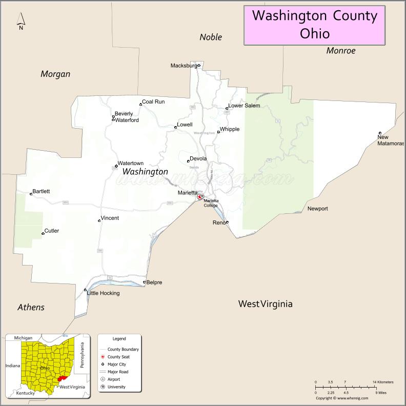
About Washington County Map, Ohio: The map showing the county boundary, county seat, major cities, highways, water bodies and neighbouring counties.
Ohio More Maps & Info
About Washington County, Ohio
Washington County is a county located in the U.S. state of Ohio. It's county seat is Marietta. As per 2020 census, the population of Washington County is 59423 people and population density is square miles. According to the United States Census Bureau, the county has a total area of 635.15 sq mi (1,645 km2). Washington County was established on -40697.
Washington County Facts
| Continent | North America |
| Country | United States |
| State | Ohio |
| County Seat | Marietta |
| Largest City/Town | Marietta |
| Established | July 27, 1788 |
| Total Area | 640 sq mi (1,658 sq km) |
| Land Area | 635 sq mi (1,645 sq km) |
| Water Area | 5.0 sq mi (13.0 sq km) |
| Population | 59,771 (Census 2020) |
| Population Density | 94 people per sq mi |
| Time Zone | Eastern Time Zone (ET) |
| Major Highways | I-77, US-50, State Route 7, State Route 26, State Route 60 |
| Neighboring Counties | Noble County, Monroe County, Athens County, Meigs County, Wood County (WV), Pleasants County (WV) |
| Famous For | First settlement in the Northwest Territory, Ohio River history, oil and gas heritage |
| Top Attractions | Campus Martius Museum, Marietta Historic District, Ohio River Museum, Blennerhassett Island nearby |
| Official Website | https://www.washingtongov.org/ |
Cities and Towns in Washington County, Ohio
- Marietta (county seat) – 13,385 (Census 2020)
- Beverly – 1,243 (Census 2020)
- Belpre (partly) – 6,660 (Census 2020, shared)
- Lowell – 542 (Census 2020)
Roads and Highways in Washington County, Ohio
Washington County is located along the Ohio River and is connected by highways that serve southeastern Ohio and West Virginia.
- I-77 – major north-south interstate connecting Ohio to West Virginia
- US-50 – east-west route running through Marietta
- State Route 7 – follows the Ohio River corridor
- State Route 26 – connects Marietta to Athens and rural communities
- State Route 60 – links Marietta to Zanesville and other inland cities
Neighboring Counties of Washington County
- Noble County (north)
- Monroe County (northwest)
- Athens County (west)
- Meigs County (southwest)
- Wood County, West Virginia (east)
- Pleasants County, West Virginia (southeast)
Top Attractions in Washington County, Ohio
Washington County offers historic sites, riverfront views, and cultural heritage.
- Campus Martius Museum – museum highlighting early Ohio settlement history
- Ohio River Museum – exhibits on river navigation and history
- Marietta Historic District – one of Ohio’s oldest towns with preserved architecture
- Blennerhassett Island State Park nearby – historic island accessible by boat
- Rufus Putnam House – historic home of an Ohio pioneer
- Marietta Riverfront – scenic views along the Ohio River
- Wayne National Forest nearby – outdoor recreation and hiking
- Marietta College campus – historic college with cultural events
Distance from Washington County to Nearby Cities
- Washington County to Columbus – 110 mi (177 km)
- Washington County to Charleston, WV – 90 mi (145 km)
- Washington County to Parkersburg, WV – 10 mi (16 km)
- Washington County to Athens – 50 mi (80 km)
- Washington County to Wheeling, WV – 75 mi (121 km)
FAQs about Washington County
Washington County is located in southeastern Ohio along the Ohio River.
It is known as the site of the first settlement in the Northwest Territory and for its Ohio River history.
The population was 59,771 according to the 2020 Census.
The county seat is Marietta.
Yes, the county offers museums, historic districts, riverfront views, and nearby state parks.
- Adams County Map
- Allen County Map
- Ashland County Map
- Ashtabula County Map
- Athens County Map
- Auglaize County Map
- Belmont County Map
- Brown County Map
- Butler County Map
- Carroll County Map
- Champaign County Map
- Clark County Map
- Clermont County Map
- Clinton County Map
- Columbiana County Map
- Coshocton County Map
- Crawford County Map
- Cuyahoga County Map
- Darke County Map
- Defiance County Map
- Delaware County Map
- Erie County Map
- Fairfield County Map
- Fayette County Map
- Franklin County Map
- Fulton County Map
- Gallia County Map
- Geauga County Map
- Greene County Map
- Guernsey County Map
- Hamilton County Map
- Hancock County Map
- Hardin County Map
- Harrison County Map
- Henry County Map
- Highland County Map
- Hocking County Map
- Holmes County Map
- Huron County Map
- Jackson County Map
- Jefferson County Map
- Knox County Map
- Lake County Map
- Lawrence County Map
- Licking County Map
- Logan County Map
- Lorain County Map
- Lucas County Map
- Madison County Map
- Mahoning County Map
- Marion County Map
- Medina County Map
- Meigs County Map
- Mercer County Map
- Miami County Map
- Monroe County Map
- Montgomery County Map
- Morgan County Map
- Morrow County Map
- Muskingum County Map
- Noble County Map
- Ottawa County Map
- Paulding County Map
- Perry County Map
- Pickaway County Map
- Pike County Map
- Portage County Map
- Preble County Map
- Putnam County Map
- Richland County Map
- Ross County Map
- Sandusky County Map
- Scioto County Map
- Seneca County Map
- Shelby County Map
- Stark County Map
- Summit County Map
- Trumbull County Map
- Tuscarawas County Map
- Union County Map
- Van Wert County Map
- Vinton County Map
- Warren County Map
- Washington County Map
- Wayne County Map
- Williams County Map
- Wood County Map
- Wyandot County Map
- Alabama Counties
- Alaska boroughs
- Arizona Counties
- Arkansas Counties
- California County Map
- Colorado Counties
- Connecticut Counties
- Delaware Counties
- Florida County Map
- Georgia County Map
- Hawaii Counties
- Idaho Counties
- Illinois Counties
- Indiana Counties
- Iowa Counties
- Kansas Counties
- Kentucky Counties
- Louisiana Counties
- Maine Counties
- Maryland Counties
- Massachusetts Counties
- Michigan County Map
- Minnesota Counties
- Mississippi Counties
- Missouri Counties
- Montana Counties
- Nebraska Counties
- Nevada Counties
- New York Counties
- New Hampshire Counties
- New Jersey Counties
- New Mexico Counties
- North Carolina Counties
- North Dakota Counties
- Ohio County Map
- Oklahoma Counties
- Oregon Counties
- Pennsylvania Counties
- Rhode Island Counties
- South Carolina Counties
- South Dakota Counties
- Map of Tennessee
- Texas County Map
- Utah Counties
- Vermont Counties
- Virginia Counties
- Washington Counties
- West Virginia Counties
- Wisconsin Counties
- Wyoming Counties