Map of Guernsey County - Guernsey County is a county located in the U.S. state of Ohio. Guernsey County Map showing cities, highways, important places and water bodies. Get Where is Guernsey County located in the map, major cities in Guernsey county, population, areas, and places of interest.
Map of Guernsey County, Ohio
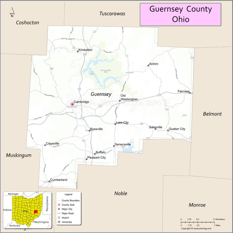
About Guernsey County Map, Ohio: The map showing the county boundary, county seat, major cities, highways, water bodies and neighbouring counties.
Ohio More Maps & Info
About Guernsey County, Ohio
Guernsey County is a county located in the U.S. state of Ohio. It's county seat is Cambridge. As per 2020 census, the population of Guernsey County is 38287 people and population density is square miles. According to the United States Census Bureau, the county has a total area of 521.90 sq mi (1,352 km2). Guernsey County was established on -32811.
Guernsey County Facts
| Continent | North America |
| Country | United States |
| State | Ohio |
| County Seat | Cambridge |
| Largest City/Town | Cambridge |
| Established | March 1, 1810 |
| Total Area | 528 sq mi (1,368 sq km) |
| Land Area | 522 sq mi (1,352 sq km) |
| Water Area | 6.0 sq mi (15.5 sq km) |
| Population | 38,438 (Census 2020) |
| Population Density | 74 people per sq mi |
| Time Zone | Eastern Time Zone (ET) |
| Major Highways | I-70, I-77, US-22, State Route 209, State Route 285, State Route 541 |
| Neighboring Counties | Noble County, Belmont County, Harrison County, Tuscarawas County, Coshocton County, Muskingum County |
| Famous For | Salt Fork State Park, rolling hills, Appalachian scenery |
| Top Attractions | Salt Fork State Park, The Wilds, Seneca Lake, Cambridge Glass Museum |
| Official Website | https://www.guernseycounty.org/ |
Cities and Towns in Guernsey County, Ohio
- Cambridge (county seat) – 10,089 (Census 2020)
- Byesville – 2,438 (Census 2020)
- Quaker City – 467 (Census 2020)
- Senecaville – 395 (Census 2020)
Roads and Highways in Guernsey County, Ohio
Guernsey County is served by major highways that connect eastern Ohio to the rest of the state and neighboring regions.
- I-70 – major east-west interstate connecting Columbus to Wheeling, West Virginia
- I-77 – north-south interstate linking Cleveland to Marietta through the county
- US-22 – east-west route connecting Cambridge to Zanesville and Steubenville
- State Route 209 – runs through Cambridge and surrounding areas
- State Route 285 – connects Senecaville to nearby rural communities
- State Route 541 – scenic route through rolling hills and countryside
Neighboring Counties of Guernsey County
- Tuscarawas County (north)
- Harrison County (northeast)
- Belmont County (east)
- Noble County (south)
- Muskingum County (west)
- Coshocton County (northwest)
Top Attractions in Guernsey County, Ohio
Guernsey County offers outdoor recreation, scenic landscapes, and unique attractions in eastern Ohio.
- Salt Fork State Park – largest state park in Ohio with camping, boating, and hiking
- The Wilds – large conservation center with safari-style tours
- Seneca Lake Park – popular for fishing, boating, and camping
- Cambridge Glass Museum – showcases the region’s glassmaking history
- Downtown Cambridge – historic area with shops and dining
- Salt Fork Lodge – scenic lodge overlooking the park and lake
- Deerassic Park – outdoor education center with wildlife programs
- National Museum of Cambridge Glass – displays historic glass collections
Distance from Guernsey County to Nearby Cities
- Guernsey County to Columbus – 80 mi (129 km)
- Guernsey County to Zanesville – 25 mi (40 km)
- Guernsey County to Wheeling – 50 mi (80 km)
- Guernsey County to Pittsburgh – 90 mi (145 km)
- Guernsey County to Cleveland – 120 mi (193 km)
FAQs about Guernsey County
Guernsey County is located in eastern Ohio in the Appalachian region.
It is known for Salt Fork State Park, scenic hills, and outdoor recreation.
The population was 38,438 according to the 2020 Census.
The county seat is Cambridge.
Yes, the county offers parks, lakes, and nature-based activities.
- Adams County Map
- Allen County Map
- Ashland County Map
- Ashtabula County Map
- Athens County Map
- Auglaize County Map
- Belmont County Map
- Brown County Map
- Butler County Map
- Carroll County Map
- Champaign County Map
- Clark County Map
- Clermont County Map
- Clinton County Map
- Columbiana County Map
- Coshocton County Map
- Crawford County Map
- Cuyahoga County Map
- Darke County Map
- Defiance County Map
- Delaware County Map
- Erie County Map
- Fairfield County Map
- Fayette County Map
- Franklin County Map
- Fulton County Map
- Gallia County Map
- Geauga County Map
- Greene County Map
- Guernsey County Map
- Hamilton County Map
- Hancock County Map
- Hardin County Map
- Harrison County Map
- Henry County Map
- Highland County Map
- Hocking County Map
- Holmes County Map
- Huron County Map
- Jackson County Map
- Jefferson County Map
- Knox County Map
- Lake County Map
- Lawrence County Map
- Licking County Map
- Logan County Map
- Lorain County Map
- Lucas County Map
- Madison County Map
- Mahoning County Map
- Marion County Map
- Medina County Map
- Meigs County Map
- Mercer County Map
- Miami County Map
- Monroe County Map
- Montgomery County Map
- Morgan County Map
- Morrow County Map
- Muskingum County Map
- Noble County Map
- Ottawa County Map
- Paulding County Map
- Perry County Map
- Pickaway County Map
- Pike County Map
- Portage County Map
- Preble County Map
- Putnam County Map
- Richland County Map
- Ross County Map
- Sandusky County Map
- Scioto County Map
- Seneca County Map
- Shelby County Map
- Stark County Map
- Summit County Map
- Trumbull County Map
- Tuscarawas County Map
- Union County Map
- Van Wert County Map
- Vinton County Map
- Warren County Map
- Washington County Map
- Wayne County Map
- Williams County Map
- Wood County Map
- Wyandot County Map
- Alabama Counties
- Alaska boroughs
- Arizona Counties
- Arkansas Counties
- California County Map
- Colorado Counties
- Connecticut Counties
- Delaware Counties
- Florida County Map
- Georgia County Map
- Hawaii Counties
- Idaho Counties
- Illinois Counties
- Indiana Counties
- Iowa Counties
- Kansas Counties
- Kentucky Counties
- Louisiana Counties
- Maine Counties
- Maryland Counties
- Massachusetts Counties
- Michigan County Map
- Minnesota Counties
- Mississippi Counties
- Missouri Counties
- Montana Counties
- Nebraska Counties
- Nevada Counties
- New York Counties
- New Hampshire Counties
- New Jersey Counties
- New Mexico Counties
- North Carolina Counties
- North Dakota Counties
- Ohio County Map
- Oklahoma Counties
- Oregon Counties
- Pennsylvania Counties
- Rhode Island Counties
- South Carolina Counties
- South Dakota Counties
- Map of Tennessee
- Texas County Map
- Utah Counties
- Vermont Counties
- Virginia Counties
- Washington Counties
- West Virginia Counties
- Wisconsin Counties
- Wyoming Counties