Map of Muskingum County - Muskingum County is a county located in the U.S. state of Ohio. Muskingum County Map showing cities, highways, important places and water bodies. Get Where is Muskingum County located in the map, major cities in Muskingum county, population, areas, and places of interest.
Map of Muskingum County, Ohio
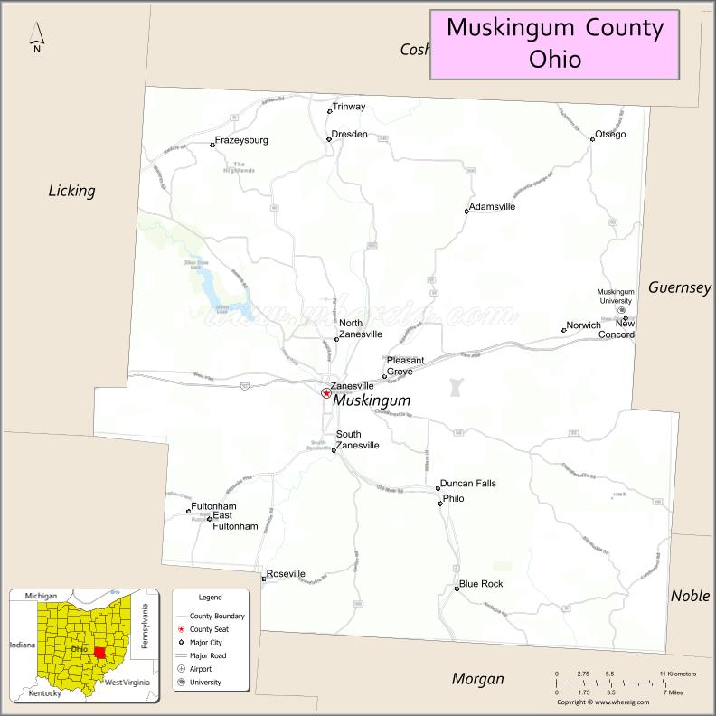
About Muskingum County Map, Ohio: The map showing the county boundary, county seat, major cities, highways, water bodies and neighbouring counties.
Ohio More Maps & Info
About Muskingum County, Ohio
Muskingum County is a county located in the U.S. state of Ohio. It's county seat is Zanesville. As per 2020 census, the population of Muskingum County is 86408 people and population density is square miles. According to the United States Census Bureau, the county has a total area of 664.63 sq mi (1,721 km2). Muskingum County was established on Mar 1, 1804[22][23].
Muskingum County Facts
| Continent | North America |
| Country | United States |
| State | Ohio |
| County Seat | Zanesville |
| Largest City/Town | Zanesville |
| Established | March 1, 1804 |
| Total Area | 673 sq mi (1,743 sq km) |
| Land Area | 664 sq mi (1,720 sq km) |
| Water Area | 9.1 sq mi (23.6 sq km) |
| Population | 86,410 (Census 2020) |
| Population Density | 130 people per sq mi |
| Time Zone | Eastern Time Zone (ET) |
| Major Highways | I-70, US-40, State Route 60, State Route 93, State Route 146 |
| Neighboring Counties | Coshocton County, Guernsey County, Noble County, Morgan County, Perry County, Licking County |
| Famous For | Y-Bridge, pottery history, Muskingum River |
| Top Attractions | Y-Bridge, Dillon State Park, The Wilds, Zanesville Museum of Art |
| Official Website | https://www.muskingumcounty.org/ |
Cities and Towns in Muskingum County, Ohio
- Zanesville (county seat) – 25,487 (Census 2020)
- Dresden – 1,529 (Census 2020)
- New Concord – 2,491 (Census 2020)
- Frazeysburg – 1,326 (Census 2020)
Roads and Highways in Muskingum County, Ohio
Muskingum County is served by major highways that connect eastern and central Ohio.
- I-70 – major east-west interstate connecting Columbus to Wheeling, West Virginia
- US-40 – historic National Road running through Zanesville
- State Route 60 – north-south route following the Muskingum River
- State Route 93 – connects Zanesville to Coshocton and southern areas
- State Route 146 – links Zanesville to Licking County and Newark
Neighboring Counties of Muskingum County
- Coshocton County (north)
- Guernsey County (east)
- Noble County (southeast)
- Morgan County (south)
- Perry County (west)
- Licking County (northwest)
Top Attractions in Muskingum County, Ohio
Muskingum County offers a mix of history, outdoor recreation, and unique landmarks.
- Y-Bridge – famous bridge in Zanesville shaped like the letter “Y”
- Dillon State Park – popular for boating, fishing, and camping
- The Wilds – large conservation center with wildlife tours
- Zanesville Museum of Art – features regional and national artwork
- Muskingum River Parkway – scenic route with locks and dams
- John McIntire Library – historic library in downtown Zanesville
- Secrest Auditorium – historic venue for performances
- Putnam Hill Historic District – area with historic homes and views
Distance from Muskingum County to Nearby Cities
- Muskingum County to Columbus – 55 mi (89 km)
- Muskingum County to Wheeling – 70 mi (113 km)
- Muskingum County to Cambridge – 25 mi (40 km)
- Muskingum County to Newark – 30 mi (48 km)
- Muskingum County to Pittsburgh – 120 mi (193 km)
FAQs about Muskingum County
Muskingum County is located in east-central Ohio.
It is known for the Y-Bridge, pottery history, and the Muskingum River.
The population was 86,410 according to the 2020 Census.
The county seat is Zanesville.
Yes, the county offers parks, museums, and unique landmarks.
- Adams County Map
- Allen County Map
- Ashland County Map
- Ashtabula County Map
- Athens County Map
- Auglaize County Map
- Belmont County Map
- Brown County Map
- Butler County Map
- Carroll County Map
- Champaign County Map
- Clark County Map
- Clermont County Map
- Clinton County Map
- Columbiana County Map
- Coshocton County Map
- Crawford County Map
- Cuyahoga County Map
- Darke County Map
- Defiance County Map
- Delaware County Map
- Erie County Map
- Fairfield County Map
- Fayette County Map
- Franklin County Map
- Fulton County Map
- Gallia County Map
- Geauga County Map
- Greene County Map
- Guernsey County Map
- Hamilton County Map
- Hancock County Map
- Hardin County Map
- Harrison County Map
- Henry County Map
- Highland County Map
- Hocking County Map
- Holmes County Map
- Huron County Map
- Jackson County Map
- Jefferson County Map
- Knox County Map
- Lake County Map
- Lawrence County Map
- Licking County Map
- Logan County Map
- Lorain County Map
- Lucas County Map
- Madison County Map
- Mahoning County Map
- Marion County Map
- Medina County Map
- Meigs County Map
- Mercer County Map
- Miami County Map
- Monroe County Map
- Montgomery County Map
- Morgan County Map
- Morrow County Map
- Muskingum County Map
- Noble County Map
- Ottawa County Map
- Paulding County Map
- Perry County Map
- Pickaway County Map
- Pike County Map
- Portage County Map
- Preble County Map
- Putnam County Map
- Richland County Map
- Ross County Map
- Sandusky County Map
- Scioto County Map
- Seneca County Map
- Shelby County Map
- Stark County Map
- Summit County Map
- Trumbull County Map
- Tuscarawas County Map
- Union County Map
- Van Wert County Map
- Vinton County Map
- Warren County Map
- Washington County Map
- Wayne County Map
- Williams County Map
- Wood County Map
- Wyandot County Map
- Alabama Counties
- Alaska boroughs
- Arizona Counties
- Arkansas Counties
- California County Map
- Colorado Counties
- Connecticut Counties
- Delaware Counties
- Florida County Map
- Georgia County Map
- Hawaii Counties
- Idaho Counties
- Illinois Counties
- Indiana Counties
- Iowa Counties
- Kansas Counties
- Kentucky Counties
- Louisiana Counties
- Maine Counties
- Maryland Counties
- Massachusetts Counties
- Michigan County Map
- Minnesota Counties
- Mississippi Counties
- Missouri Counties
- Montana Counties
- Nebraska Counties
- Nevada Counties
- New York Counties
- New Hampshire Counties
- New Jersey Counties
- New Mexico Counties
- North Carolina Counties
- North Dakota Counties
- Ohio County Map
- Oklahoma Counties
- Oregon Counties
- Pennsylvania Counties
- Rhode Island Counties
- South Carolina Counties
- South Dakota Counties
- Map of Tennessee
- Texas County Map
- Utah Counties
- Vermont Counties
- Virginia Counties
- Washington Counties
- West Virginia Counties
- Wisconsin Counties
- Wyoming Counties