Map of Hardin County - Hardin County is a county located in the U.S. state of Ohio. Hardin County Map showing cities, highways, important places and water bodies. Get Where is Hardin County located in the map, major cities in Hardin county, population, areas, and places of interest.
Map of Hardin County, Ohio
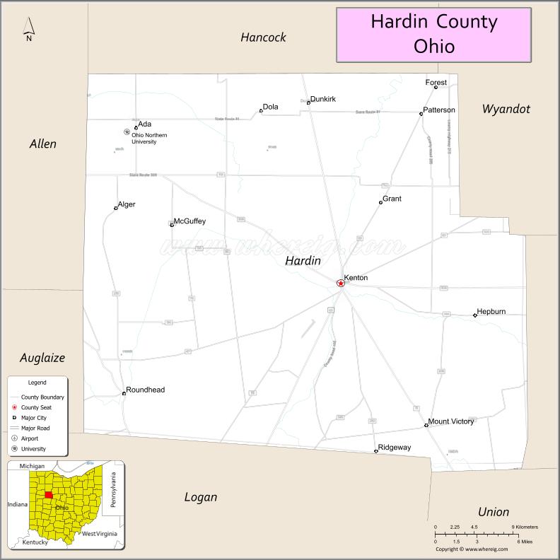
About Hardin County Map, Ohio: The map showing the county boundary, county seat, major cities, highways, water bodies and neighbouring counties.
Ohio More Maps & Info
About Hardin County, Ohio
Hardin County is a county located in the U.S. state of Ohio. It's county seat is Kenton. As per 2020 census, the population of Hardin County is 30621 people and population density is square miles. According to the United States Census Bureau, the county has a total area of 470.29 sq mi (1,218 km2). Hardin County was established on -29127.
Hardin County Facts
| Continent | North America |
| Country | United States |
| State | Ohio |
| County Seat | Kenton |
| Largest City/Town | Kenton |
| Established | April 1, 1820 |
| Total Area | 471 sq mi (1,220 sq km) |
| Land Area | 470 sq mi (1,217 sq km) |
| Water Area | 1.2 sq mi (3.1 sq km) |
| Population | 30,696 (Census 2020) |
| Population Density | 65 people per sq mi |
| Time Zone | Eastern Time Zone (ET) |
| Major Highways | US-30, US-68, State Route 31, State Route 67, State Route 81 |
| Neighboring Counties | Hancock County, Wyandot County, Marion County, Union County, Logan County, Allen County |
| Famous For | Agriculture, rural landscapes, small-town communities |
| Top Attractions | Hardin County Courthouse, Hog Creek Wildlife Area, Veterans Memorial Park, local fairs |
| Official Website | https://www.co.hardin.oh.us/ |
Cities and Towns in Hardin County, Ohio
- Kenton (county seat) – 8,262 (Census 2020)
- Ada – 5,952 (Census 2020)
- Forest – 1,391 (Census 2020)
- Mount Victory – 627 (Census 2020)
Roads and Highways in Hardin County, Ohio
Hardin County is connected by several highways that provide access to nearby cities and regional routes across Ohio.
- US-30 – major east-west route connecting the county to Lima and Mansfield
- US-68 – north-south highway linking Findlay to Springfield
- State Route 31 – connects Kenton to Marysville and surrounding areas
- State Route 67 – runs east-west linking Kenton to Bellefontaine
- State Route 81 – connects Ada to Lima and Kenton
Neighboring Counties of Hardin County
- Hancock County (north)
- Wyandot County (northeast)
- Marion County (east)
- Union County (southeast)
- Logan County (south)
- Allen County (west)
Top Attractions in Hardin County, Ohio
Hardin County offers a quiet rural setting with local parks, historic sites, and community events.
- Hardin County Courthouse – historic building in downtown Kenton
- Hog Creek Wildlife Area – natural area for hiking, fishing, and wildlife viewing
- Veterans Memorial Park – community park with monuments and green space
- Ohio Northern University in Ada – small university with a scenic campus
- Hardin County Fairgrounds – hosts annual fairs and events
- McIntosh Park – local park with playgrounds and walking paths
- Geneva Park – quiet spot for relaxation and outdoor activities
- Downtown Kenton – small-town area with shops and dining
Distance from Hardin County to Nearby Cities
- Hardin County to Columbus – 75 mi (121 km)
- Hardin County to Lima – 30 mi (48 km)
- Hardin County to Findlay – 40 mi (64 km)
- Hardin County to Dayton – 80 mi (129 km)
- Hardin County to Toledo – 95 mi (153 km)
FAQs about Hardin County
Hardin County is located in north-central Ohio.
It is known for agriculture, rural communities, and Ohio Northern University.
The population was 30,696 according to the 2020 Census.
The county seat is Kenton.
Yes, the county offers parks, wildlife areas, and recreational spaces.
- Adams County Map
- Allen County Map
- Ashland County Map
- Ashtabula County Map
- Athens County Map
- Auglaize County Map
- Belmont County Map
- Brown County Map
- Butler County Map
- Carroll County Map
- Champaign County Map
- Clark County Map
- Clermont County Map
- Clinton County Map
- Columbiana County Map
- Coshocton County Map
- Crawford County Map
- Cuyahoga County Map
- Darke County Map
- Defiance County Map
- Delaware County Map
- Erie County Map
- Fairfield County Map
- Fayette County Map
- Franklin County Map
- Fulton County Map
- Gallia County Map
- Geauga County Map
- Greene County Map
- Guernsey County Map
- Hamilton County Map
- Hancock County Map
- Hardin County Map
- Harrison County Map
- Henry County Map
- Highland County Map
- Hocking County Map
- Holmes County Map
- Huron County Map
- Jackson County Map
- Jefferson County Map
- Knox County Map
- Lake County Map
- Lawrence County Map
- Licking County Map
- Logan County Map
- Lorain County Map
- Lucas County Map
- Madison County Map
- Mahoning County Map
- Marion County Map
- Medina County Map
- Meigs County Map
- Mercer County Map
- Miami County Map
- Monroe County Map
- Montgomery County Map
- Morgan County Map
- Morrow County Map
- Muskingum County Map
- Noble County Map
- Ottawa County Map
- Paulding County Map
- Perry County Map
- Pickaway County Map
- Pike County Map
- Portage County Map
- Preble County Map
- Putnam County Map
- Richland County Map
- Ross County Map
- Sandusky County Map
- Scioto County Map
- Seneca County Map
- Shelby County Map
- Stark County Map
- Summit County Map
- Trumbull County Map
- Tuscarawas County Map
- Union County Map
- Van Wert County Map
- Vinton County Map
- Warren County Map
- Washington County Map
- Wayne County Map
- Williams County Map
- Wood County Map
- Wyandot County Map
- Alabama Counties
- Alaska boroughs
- Arizona Counties
- Arkansas Counties
- California County Map
- Colorado Counties
- Connecticut Counties
- Delaware Counties
- Florida County Map
- Georgia County Map
- Hawaii Counties
- Idaho Counties
- Illinois Counties
- Indiana Counties
- Iowa Counties
- Kansas Counties
- Kentucky Counties
- Louisiana Counties
- Maine Counties
- Maryland Counties
- Massachusetts Counties
- Michigan County Map
- Minnesota Counties
- Mississippi Counties
- Missouri Counties
- Montana Counties
- Nebraska Counties
- Nevada Counties
- New York Counties
- New Hampshire Counties
- New Jersey Counties
- New Mexico Counties
- North Carolina Counties
- North Dakota Counties
- Ohio County Map
- Oklahoma Counties
- Oregon Counties
- Pennsylvania Counties
- Rhode Island Counties
- South Carolina Counties
- South Dakota Counties
- Map of Tennessee
- Texas County Map
- Utah Counties
- Vermont Counties
- Virginia Counties
- Washington Counties
- West Virginia Counties
- Wisconsin Counties
- Wyoming Counties