Map of Putnam County - Putnam County is a county located in the U.S. state of Ohio. Putnam County Map showing cities, highways, important places and water bodies. Get Where is Putnam County located in the map, major cities in Putnam county, population, areas, and places of interest.
Map of Putnam County, Ohio
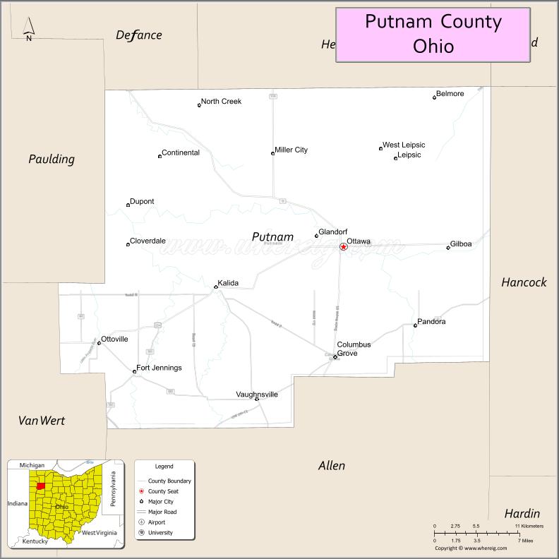
About Putnam County Map, Ohio: The map showing the county boundary, county seat, major cities, highways, water bodies and neighbouring counties.
Ohio More Maps & Info
About Putnam County, Ohio
Putnam County is a county located in the U.S. state of Ohio. It's county seat is Ottawa. As per 2020 census, the population of Putnam County is 34318 people and population density is square miles. According to the United States Census Bureau, the county has a total area of 483.87 sq mi (1,253 km2). Putnam County was established on -29127.
Putnam County Facts
| Continent | North America |
| Country | United States |
| State | Ohio |
| County Seat | Ottawa |
| Largest City/Town | Ottawa |
| Established | April 1, 1820 |
| Total Area | 484 sq mi (1,253 sq km) |
| Land Area | 483 sq mi (1,251 sq km) |
| Water Area | 1.8 sq mi (4.7 sq km) |
| Population | 34,451 (Census 2020) |
| Population Density | 71 people per sq mi |
| Time Zone | Eastern Time Zone (ET) |
| Major Highways | US-224, State Route 15, State Route 12, State Route 65, State Route 189 |
| Neighboring Counties | Henry County, Hancock County, Allen County, Van Wert County, Defiance County |
| Famous For | Agriculture, rural communities, Blanchard River |
| Top Attractions | Ottawa Metro Park, Putnam County Fairgrounds, Blanchard River, Gilboa Quarry |
| Official Website | https://putnamcountyohio.gov/ |
Cities and Towns in Putnam County, Ohio
- Ottawa (county seat) – 4,485 (Census 2020)
- Columbus Grove – 2,140 (Census 2020)
- Leipsic – 2,260 (Census 2020)
- Ottoville – 972 (Census 2020)
Roads and Highways in Putnam County, Ohio
Putnam County is connected by highways that link it to northwest Ohio and surrounding rural communities.
- US-224 – major east-west route connecting Ottawa to Findlay and Van Wert
- State Route 15 – runs through the county linking Ottawa to Defiance and Lima
- State Route 12 – connects Columbus Grove to Findlay and surrounding areas
- State Route 65 – runs north-south along the Blanchard River
- State Route 189 – links Ottawa to nearby towns and farmland
Neighboring Counties of Putnam County
- Henry County (north)
- Hancock County (east)
- Allen County (south)
- Van Wert County (southwest)
- Defiance County (west)
Top Attractions in Putnam County, Ohio
Putnam County offers outdoor recreation, small-town charm, and local heritage.
- Ottawa Metro Park – popular for walking, fishing, and picnicking
- Blanchard River – scenic river for outdoor activities
- Putnam County Fairgrounds – hosts annual fairs and community events
- Gilboa Quarry – unique geological site and fishing area
- Leipsic village area – charming community with local shops
- Columbus Grove parks – recreational spaces and green areas
- Ottoville community – small-town atmosphere and local events
- Rural countryside – scenic farmland and quiet landscapes
Distance from Putnam County to Nearby Cities
- Putnam County to Findlay – 30 mi (48 km)
- Putnam County to Lima – 20 mi (32 km)
- Putnam County to Toledo – 70 mi (113 km)
- Putnam County to Columbus – 110 mi (177 km)
- Putnam County to Fort Wayne – 70 mi (113 km)
FAQs about Putnam County
Putnam County is located in northwestern Ohio.
It is known for agriculture, rural communities, and the Blanchard River.
The population was 34,451 according to the 2020 Census.
The county seat is Ottawa.
Yes, the county offers parks, rivers, and community events.
- Adams County Map
- Allen County Map
- Ashland County Map
- Ashtabula County Map
- Athens County Map
- Auglaize County Map
- Belmont County Map
- Brown County Map
- Butler County Map
- Carroll County Map
- Champaign County Map
- Clark County Map
- Clermont County Map
- Clinton County Map
- Columbiana County Map
- Coshocton County Map
- Crawford County Map
- Cuyahoga County Map
- Darke County Map
- Defiance County Map
- Delaware County Map
- Erie County Map
- Fairfield County Map
- Fayette County Map
- Franklin County Map
- Fulton County Map
- Gallia County Map
- Geauga County Map
- Greene County Map
- Guernsey County Map
- Hamilton County Map
- Hancock County Map
- Hardin County Map
- Harrison County Map
- Henry County Map
- Highland County Map
- Hocking County Map
- Holmes County Map
- Huron County Map
- Jackson County Map
- Jefferson County Map
- Knox County Map
- Lake County Map
- Lawrence County Map
- Licking County Map
- Logan County Map
- Lorain County Map
- Lucas County Map
- Madison County Map
- Mahoning County Map
- Marion County Map
- Medina County Map
- Meigs County Map
- Mercer County Map
- Miami County Map
- Monroe County Map
- Montgomery County Map
- Morgan County Map
- Morrow County Map
- Muskingum County Map
- Noble County Map
- Ottawa County Map
- Paulding County Map
- Perry County Map
- Pickaway County Map
- Pike County Map
- Portage County Map
- Preble County Map
- Putnam County Map
- Richland County Map
- Ross County Map
- Sandusky County Map
- Scioto County Map
- Seneca County Map
- Shelby County Map
- Stark County Map
- Summit County Map
- Trumbull County Map
- Tuscarawas County Map
- Union County Map
- Van Wert County Map
- Vinton County Map
- Warren County Map
- Washington County Map
- Wayne County Map
- Williams County Map
- Wood County Map
- Wyandot County Map
- Alabama Counties
- Alaska boroughs
- Arizona Counties
- Arkansas Counties
- California County Map
- Colorado Counties
- Connecticut Counties
- Delaware Counties
- Florida County Map
- Georgia County Map
- Hawaii Counties
- Idaho Counties
- Illinois Counties
- Indiana Counties
- Iowa Counties
- Kansas Counties
- Kentucky Counties
- Louisiana Counties
- Maine Counties
- Maryland Counties
- Massachusetts Counties
- Michigan County Map
- Minnesota Counties
- Mississippi Counties
- Missouri Counties
- Montana Counties
- Nebraska Counties
- Nevada Counties
- New York Counties
- New Hampshire Counties
- New Jersey Counties
- New Mexico Counties
- North Carolina Counties
- North Dakota Counties
- Ohio County Map
- Oklahoma Counties
- Oregon Counties
- Pennsylvania Counties
- Rhode Island Counties
- South Carolina Counties
- South Dakota Counties
- Map of Tennessee
- Texas County Map
- Utah Counties
- Vermont Counties
- Virginia Counties
- Washington Counties
- West Virginia Counties
- Wisconsin Counties
- Wyoming Counties