Map of Holmes County - Holmes County is a county located in the U.S. state of Ohio. Holmes County Map showing cities, highways, important places and water bodies. Get Where is Holmes County located in the map, major cities in Holmes county, population, areas, and places of interest.
Map of Holmes County, Ohio
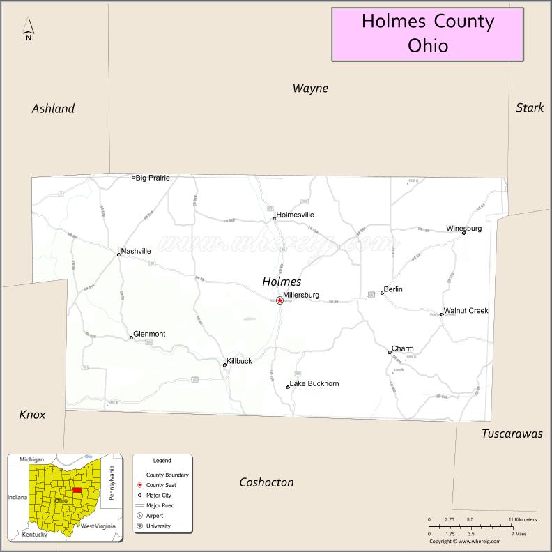
About Holmes County Map, Ohio: The map showing the county boundary, county seat, major cities, highways, water bodies and neighbouring counties.
Ohio More Maps & Info
About Holmes County, Ohio
Holmes County is a county located in the U.S. state of Ohio. It's county seat is Millersburg. As per 2020 census, the population of Holmes County is 44271 people and population density is square miles. According to the United States Census Bureau, the county has a total area of 422.99 sq mi (1,096 km2). Holmes County was established on -27738.
Holmes County Facts
| Continent | North America |
| Country | United States |
| State | Ohio |
| County Seat | Millersburg |
| Largest City/Town | Millersburg |
| Established | January 20, 1824 |
| Total Area | 424 sq mi (1,098 sq km) |
| Land Area | 423 sq mi (1,095 sq km) |
| Water Area | 1.0 sq mi (2.6 sq km) |
| Population | 44,422 (Census 2020) |
| Population Density | 105 people per sq mi |
| Time Zone | Eastern Time Zone (ET) |
| Major Highways | US-62, State Route 39, State Route 83, State Route 93, State Route 241 |
| Neighboring Counties | Wayne County, Ashland County, Knox County, Coshocton County, Tuscarawas County |
| Famous For | Amish Country, rolling hills, traditional crafts and farming |
| Top Attractions | Amish Country tours, Yoder’s Amish Home, Holmes County Trail, Millersburg Historic District |
| Official Website | https://www.holmescountyauditor.org/ |
Cities and Towns in Holmes County, Ohio
- Millersburg (county seat) – 3,103 (Census 2020)
- Baltic (partly) – 795 (Census 2020)
- Killbuck – 817 (Census 2020)
- Nashville – 197 (Census 2020)
Roads and Highways in Holmes County, Ohio
Holmes County is connected by scenic highways that pass through rural landscapes and Amish communities.
- US-62 – major route connecting Millersburg to Canton and Columbus
- State Route 39 – east-west highway linking Millersburg to Wooster and Coshocton
- State Route 83 – runs north-south through Amish Country and scenic countryside
- State Route 93 – connects the county to neighboring rural areas
- State Route 241 – links Millersburg to Wooster and surrounding communities
Neighboring Counties of Holmes County
- Wayne County (north)
- Ashland County (northwest)
- Knox County (southwest)
- Coshocton County (south)
- Tuscarawas County (east)
Top Attractions in Holmes County, Ohio
Holmes County is known for its Amish culture, scenic countryside, and traditional crafts.
- Amish Country – largest Amish population in Ohio with shops and local goods
- Yoder’s Amish Home – offers tours and a glimpse into Amish life
- Holmes County Trail – popular for biking and walking through scenic areas
- Millersburg Historic District – charming downtown with shops and restaurants
- Keim Lumber Company – unique store with local products and crafts
- Hershberger’s Farm and Bakery – family-friendly destination with baked goods
- Charm area – known for shopping, food, and Amish culture
- Berlin Village – popular tourist spot with local shops and markets
Distance from Holmes County to Nearby Cities
- Holmes County to Columbus – 80 mi (129 km)
- Holmes County to Cleveland – 75 mi (121 km)
- Holmes County to Akron – 50 mi (80 km)
- Holmes County to Canton – 45 mi (72 km)
- Holmes County to Wooster – 25 mi (40 km)
FAQs about Holmes County
Holmes County is located in northeastern Ohio.
It is known for Amish Country, traditional crafts, and scenic rural landscapes.
The population was 44,422 according to the 2020 Census.
The county seat is Millersburg.
Yes, the county offers Amish tours, local markets, trails, and historic sites.
- Adams County Map
- Allen County Map
- Ashland County Map
- Ashtabula County Map
- Athens County Map
- Auglaize County Map
- Belmont County Map
- Brown County Map
- Butler County Map
- Carroll County Map
- Champaign County Map
- Clark County Map
- Clermont County Map
- Clinton County Map
- Columbiana County Map
- Coshocton County Map
- Crawford County Map
- Cuyahoga County Map
- Darke County Map
- Defiance County Map
- Delaware County Map
- Erie County Map
- Fairfield County Map
- Fayette County Map
- Franklin County Map
- Fulton County Map
- Gallia County Map
- Geauga County Map
- Greene County Map
- Guernsey County Map
- Hamilton County Map
- Hancock County Map
- Hardin County Map
- Harrison County Map
- Henry County Map
- Highland County Map
- Hocking County Map
- Holmes County Map
- Huron County Map
- Jackson County Map
- Jefferson County Map
- Knox County Map
- Lake County Map
- Lawrence County Map
- Licking County Map
- Logan County Map
- Lorain County Map
- Lucas County Map
- Madison County Map
- Mahoning County Map
- Marion County Map
- Medina County Map
- Meigs County Map
- Mercer County Map
- Miami County Map
- Monroe County Map
- Montgomery County Map
- Morgan County Map
- Morrow County Map
- Muskingum County Map
- Noble County Map
- Ottawa County Map
- Paulding County Map
- Perry County Map
- Pickaway County Map
- Pike County Map
- Portage County Map
- Preble County Map
- Putnam County Map
- Richland County Map
- Ross County Map
- Sandusky County Map
- Scioto County Map
- Seneca County Map
- Shelby County Map
- Stark County Map
- Summit County Map
- Trumbull County Map
- Tuscarawas County Map
- Union County Map
- Van Wert County Map
- Vinton County Map
- Warren County Map
- Washington County Map
- Wayne County Map
- Williams County Map
- Wood County Map
- Wyandot County Map
- Alabama Counties
- Alaska boroughs
- Arizona Counties
- Arkansas Counties
- California County Map
- Colorado Counties
- Connecticut Counties
- Delaware Counties
- Florida County Map
- Georgia County Map
- Hawaii Counties
- Idaho Counties
- Illinois Counties
- Indiana Counties
- Iowa Counties
- Kansas Counties
- Kentucky Counties
- Louisiana Counties
- Maine Counties
- Maryland Counties
- Massachusetts Counties
- Michigan County Map
- Minnesota Counties
- Mississippi Counties
- Missouri Counties
- Montana Counties
- Nebraska Counties
- Nevada Counties
- New York Counties
- New Hampshire Counties
- New Jersey Counties
- New Mexico Counties
- North Carolina Counties
- North Dakota Counties
- Ohio County Map
- Oklahoma Counties
- Oregon Counties
- Pennsylvania Counties
- Rhode Island Counties
- South Carolina Counties
- South Dakota Counties
- Map of Tennessee
- Texas County Map
- Utah Counties
- Vermont Counties
- Virginia Counties
- Washington Counties
- West Virginia Counties
- Wisconsin Counties
- Wyoming Counties