Map of Monroe County - Monroe County is a county located in the U.S. state of Ohio. Monroe County Map showing cities, highways, important places and water bodies. Get Where is Monroe County located in the map, major cities in Monroe county, population, areas, and places of interest.
Map of Monroe County, Ohio
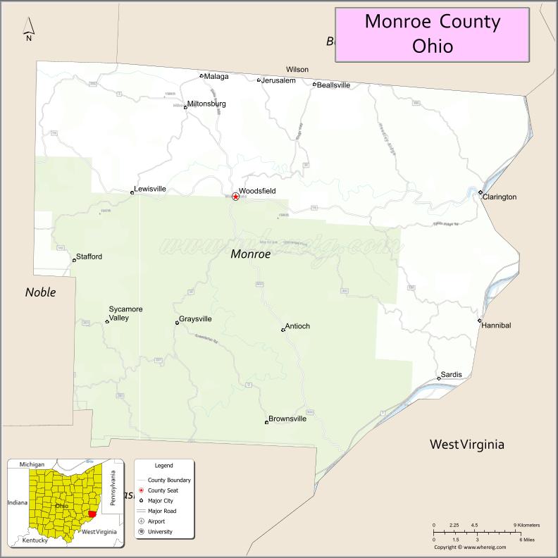
About Monroe County Map, Ohio: The map showing the county boundary, county seat, major cities, highways, water bodies and neighbouring counties.
Ohio More Maps & Info
About Monroe County, Ohio
Monroe County is a county located in the U.S. state of Ohio. It's county seat is Woodsfield. As per 2020 census, the population of Monroe County is 13329 people and population density is square miles. According to the United States Census Bureau, the county has a total area of 455.54 sq mi (1,180 km2). Monroe County was established on -31746.
Monroe County Facts
| Continent | North America |
| Country | United States |
| State | Ohio |
| County Seat | Woodsfield |
| Largest City/Town | Woodsfield |
| Established | January 29, 1813 |
| Total Area | 457 sq mi (1,184 sq km) |
| Land Area | 456 sq mi (1,181 sq km) |
| Water Area | 1.2 sq mi (3.1 sq km) |
| Population | 13,085 (Census 2020) |
| Population Density | 29 people per sq mi |
| Time Zone | Eastern Time Zone (ET) |
| Major Highways | State Route 7, State Route 26, State Route 78, State Route 145, State Route 255 |
| Neighboring Counties | Belmont County, Noble County, Washington County, Tyler County (WV), Wetzel County (WV) |
| Famous For | Ohio River, rural Appalachian landscape, oil and gas production |
| Top Attractions | Wayne National Forest, Ohio River Scenic Byway, Fly Fishing Museum, Covered bridges |
| Official Website | https://www.monroecountyohio.com/ |
Cities and Towns in Monroe County, Ohio
- Woodsfield (county seat) – 2,384 (Census 2020)
- Hannibal – 399 (Census 2020)
- Clarington – 384 (Census 2020)
- Graysville – 70 (Census 2020)
Roads and Highways in Monroe County, Ohio
Monroe County is served by scenic highways that run through the Appalachian foothills and along the Ohio River.
- State Route 7 – major north-south route following the Ohio River through the county
- State Route 26 – scenic highway connecting Woodsfield to Marietta
- State Route 78 – east-west route linking Monroe County to McConnelsville and Caldwell
- State Route 145 – connects Woodsfield to Belmont County
- State Route 255 – runs through rural areas connecting small communities
Neighboring Counties of Monroe County
- Belmont County (north)
- Noble County (west)
- Washington County (south)
- Tyler County, West Virginia (east)
- Wetzel County, West Virginia (northeast)
Top Attractions in Monroe County, Ohio
Monroe County offers scenic views, outdoor recreation, and small-town charm in southeastern Ohio.
- Wayne National Forest – large forest area with hiking, camping, and wildlife
- Ohio River Scenic Byway – scenic drive along the river with beautiful views
- Monroe Theatre – historic theater in Woodsfield
- Covered bridges – historic bridges located throughout the county
- Fly Fishing Museum – unique museum focused on fishing history
- Hannibal Locks and Dam – interesting site along the Ohio River
- Woodsfield Historic District – downtown area with local shops and history
- Riverfront areas – peaceful spots for fishing and relaxing
Distance from Monroe County to Nearby Cities
- Monroe County to Marietta – 40 mi (64 km)
- Monroe County to Wheeling – 45 mi (72 km)
- Monroe County to Parkersburg – 60 mi (97 km)
- Monroe County to Columbus – 120 mi (193 km)
- Monroe County to Pittsburgh – 110 mi (177 km)
FAQs about Monroe County
Monroe County is located in southeastern Ohio along the Ohio River.
It is known for its rural Appalachian landscape, oil and gas production, and riverfront views.
The population was 13,085 according to the 2020 Census.
The county seat is Woodsfield.
Yes, the county offers forests, scenic drives, and historic sites.
- Adams County Map
- Allen County Map
- Ashland County Map
- Ashtabula County Map
- Athens County Map
- Auglaize County Map
- Belmont County Map
- Brown County Map
- Butler County Map
- Carroll County Map
- Champaign County Map
- Clark County Map
- Clermont County Map
- Clinton County Map
- Columbiana County Map
- Coshocton County Map
- Crawford County Map
- Cuyahoga County Map
- Darke County Map
- Defiance County Map
- Delaware County Map
- Erie County Map
- Fairfield County Map
- Fayette County Map
- Franklin County Map
- Fulton County Map
- Gallia County Map
- Geauga County Map
- Greene County Map
- Guernsey County Map
- Hamilton County Map
- Hancock County Map
- Hardin County Map
- Harrison County Map
- Henry County Map
- Highland County Map
- Hocking County Map
- Holmes County Map
- Huron County Map
- Jackson County Map
- Jefferson County Map
- Knox County Map
- Lake County Map
- Lawrence County Map
- Licking County Map
- Logan County Map
- Lorain County Map
- Lucas County Map
- Madison County Map
- Mahoning County Map
- Marion County Map
- Medina County Map
- Meigs County Map
- Mercer County Map
- Miami County Map
- Monroe County Map
- Montgomery County Map
- Morgan County Map
- Morrow County Map
- Muskingum County Map
- Noble County Map
- Ottawa County Map
- Paulding County Map
- Perry County Map
- Pickaway County Map
- Pike County Map
- Portage County Map
- Preble County Map
- Putnam County Map
- Richland County Map
- Ross County Map
- Sandusky County Map
- Scioto County Map
- Seneca County Map
- Shelby County Map
- Stark County Map
- Summit County Map
- Trumbull County Map
- Tuscarawas County Map
- Union County Map
- Van Wert County Map
- Vinton County Map
- Warren County Map
- Washington County Map
- Wayne County Map
- Williams County Map
- Wood County Map
- Wyandot County Map
- Alabama Counties
- Alaska boroughs
- Arizona Counties
- Arkansas Counties
- California County Map
- Colorado Counties
- Connecticut Counties
- Delaware Counties
- Florida County Map
- Georgia County Map
- Hawaii Counties
- Idaho Counties
- Illinois Counties
- Indiana Counties
- Iowa Counties
- Kansas Counties
- Kentucky Counties
- Louisiana Counties
- Maine Counties
- Maryland Counties
- Massachusetts Counties
- Michigan County Map
- Minnesota Counties
- Mississippi Counties
- Missouri Counties
- Montana Counties
- Nebraska Counties
- Nevada Counties
- New York Counties
- New Hampshire Counties
- New Jersey Counties
- New Mexico Counties
- North Carolina Counties
- North Dakota Counties
- Ohio County Map
- Oklahoma Counties
- Oregon Counties
- Pennsylvania Counties
- Rhode Island Counties
- South Carolina Counties
- South Dakota Counties
- Map of Tennessee
- Texas County Map
- Utah Counties
- Vermont Counties
- Virginia Counties
- Washington Counties
- West Virginia Counties
- Wisconsin Counties
- Wyoming Counties