Map of Scioto County - Scioto County is a county located in the U.S. state of Ohio. Scioto County Map showing cities, highways, important places and water bodies. Get Where is Scioto County located in the map, major cities in Scioto county, population, areas, and places of interest.
Map of Scioto County, Ohio
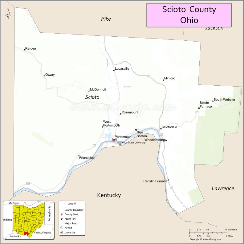
About Scioto County Map, Ohio: The map showing the county boundary, county seat, major cities, highways, water bodies and neighbouring counties.
Ohio More Maps & Info
About Scioto County, Ohio
Scioto County is a county located in the U.S. state of Ohio. It's county seat is Portsmouth. As per 2020 census, the population of Scioto County is 73346 people and population density is square miles. According to the United States Census Bureau, the county has a total area of 612.27 sq mi (1,586 km2). Scioto County was established on -35307.
Scioto County Facts
| Continent | North America |
| Country | United States |
| State | Ohio |
| County Seat | Portsmouth |
| Largest City/Town | Portsmouth |
| Established | March 24, 1803 |
| Total Area | 620 sq mi (1,606 sq km) |
| Land Area | 612 sq mi (1,585 sq km) |
| Water Area | 7.9 sq mi (20.5 sq km) |
| Population | 74,008 (Census 2020) |
| Population Density | 121 people per sq mi |
| Time Zone | Eastern Time Zone (ET) |
| Major Highways | US-23, US-52, US-35, State Route 73, State Route 139 |
| Neighboring Counties | Pike County, Jackson County, Lawrence County, Adams County, Greenup County (KY) |
| Famous For | Ohio River, Portsmouth murals, Appalachian heritage |
| Top Attractions | Portsmouth Floodwall Murals, Shawnee State Park, Scioto Trail State Park nearby, Ohio River |
| Official Website | https://www.sciotocountyohio.gov/ |
Cities and Towns in Scioto County, Ohio
- Portsmouth (county seat) – 18,252 (Census 2020)
- New Boston – 2,272 (Census 2020)
- Wheelersburg – 6,531 (Census 2020)
- Minford – 693 (Census 2020)
Roads and Highways in Scioto County, Ohio
Scioto County is served by major highways that connect it to southern Ohio and neighboring Kentucky.
- US-23 – major north-south route connecting Portsmouth to Columbus and Kentucky
- US-52 – runs east-west along the Ohio River
- US-35 – connects the county to Jackson and Chillicothe
- State Route 73 – links Portsmouth to Peebles and surrounding areas
- State Route 139 – connects the county to Jackson and Lawrence counties
Neighboring Counties of Scioto County
- Pike County (north)
- Jackson County (northwest)
- Adams County (west)
- Lawrence County (east)
- Greenup County, Kentucky (south)
Top Attractions in Scioto County, Ohio
Scioto County offers scenic river views, outdoor recreation, and cultural landmarks.
- Portsmouth Floodwall Murals – large murals depicting local history
- Shawnee State Park – popular for hiking, camping, and wildlife viewing
- Ohio River – scenic river for boating and fishing
- Shawnee State Forest – large forest area with trails and scenic overlooks
- Scioto Trail State Park nearby – outdoor recreation and camping
- Southern Ohio Museum – features regional art and history
- Portsmouth Historic District – downtown area with shops and history
- Greenbo Lake nearby – recreational area in Kentucky
Distance from Scioto County to Nearby Cities
- Scioto County to Columbus – 90 mi (145 km)
- Scioto County to Cincinnati – 100 mi (161 km)
- Scioto County to Huntington – 50 mi (80 km)
- Scioto County to Charleston – 100 mi (161 km)
- Scioto County to Lexington – 120 mi (193 km)
FAQs about Scioto County
Scioto County is located in southern Ohio along the Ohio River.
It is known for Portsmouth murals, the Ohio River, and Appalachian heritage.
The population was 74,008 according to the 2020 Census.
The county seat is Portsmouth.
Yes, the county offers parks, forests, and cultural attractions.
- Adams County Map
- Allen County Map
- Ashland County Map
- Ashtabula County Map
- Athens County Map
- Auglaize County Map
- Belmont County Map
- Brown County Map
- Butler County Map
- Carroll County Map
- Champaign County Map
- Clark County Map
- Clermont County Map
- Clinton County Map
- Columbiana County Map
- Coshocton County Map
- Crawford County Map
- Cuyahoga County Map
- Darke County Map
- Defiance County Map
- Delaware County Map
- Erie County Map
- Fairfield County Map
- Fayette County Map
- Franklin County Map
- Fulton County Map
- Gallia County Map
- Geauga County Map
- Greene County Map
- Guernsey County Map
- Hamilton County Map
- Hancock County Map
- Hardin County Map
- Harrison County Map
- Henry County Map
- Highland County Map
- Hocking County Map
- Holmes County Map
- Huron County Map
- Jackson County Map
- Jefferson County Map
- Knox County Map
- Lake County Map
- Lawrence County Map
- Licking County Map
- Logan County Map
- Lorain County Map
- Lucas County Map
- Madison County Map
- Mahoning County Map
- Marion County Map
- Medina County Map
- Meigs County Map
- Mercer County Map
- Miami County Map
- Monroe County Map
- Montgomery County Map
- Morgan County Map
- Morrow County Map
- Muskingum County Map
- Noble County Map
- Ottawa County Map
- Paulding County Map
- Perry County Map
- Pickaway County Map
- Pike County Map
- Portage County Map
- Preble County Map
- Putnam County Map
- Richland County Map
- Ross County Map
- Sandusky County Map
- Scioto County Map
- Seneca County Map
- Shelby County Map
- Stark County Map
- Summit County Map
- Trumbull County Map
- Tuscarawas County Map
- Union County Map
- Van Wert County Map
- Vinton County Map
- Warren County Map
- Washington County Map
- Wayne County Map
- Williams County Map
- Wood County Map
- Wyandot County Map
- Alabama Counties
- Alaska boroughs
- Arizona Counties
- Arkansas Counties
- California County Map
- Colorado Counties
- Connecticut Counties
- Delaware Counties
- Florida County Map
- Georgia County Map
- Hawaii Counties
- Idaho Counties
- Illinois Counties
- Indiana Counties
- Iowa Counties
- Kansas Counties
- Kentucky Counties
- Louisiana Counties
- Maine Counties
- Maryland Counties
- Massachusetts Counties
- Michigan County Map
- Minnesota Counties
- Mississippi Counties
- Missouri Counties
- Montana Counties
- Nebraska Counties
- Nevada Counties
- New York Counties
- New Hampshire Counties
- New Jersey Counties
- New Mexico Counties
- North Carolina Counties
- North Dakota Counties
- Ohio County Map
- Oklahoma Counties
- Oregon Counties
- Pennsylvania Counties
- Rhode Island Counties
- South Carolina Counties
- South Dakota Counties
- Map of Tennessee
- Texas County Map
- Utah Counties
- Vermont Counties
- Virginia Counties
- Washington Counties
- West Virginia Counties
- Wisconsin Counties
- Wyoming Counties