Map of Jefferson County - Jefferson County is a county located in the U.S. state of Ohio. Jefferson County Map showing cities, highways, important places and water bodies. Get Where is Jefferson County located in the map, major cities in Jefferson county, population, areas, and places of interest.
Map of Jefferson County, Ohio
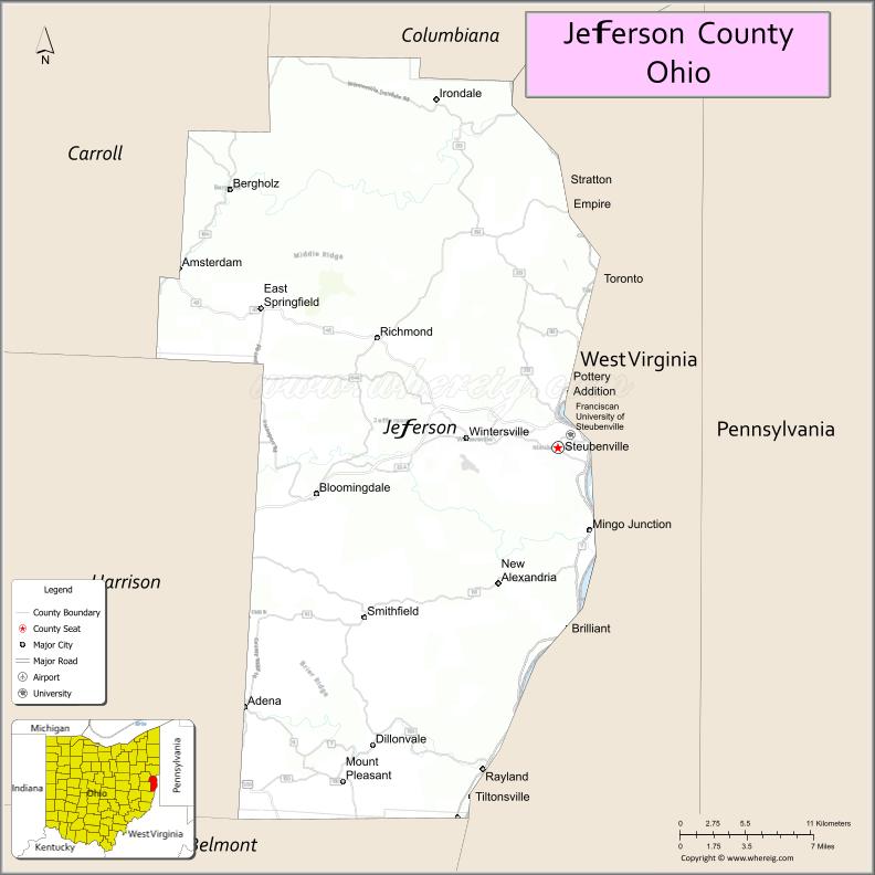
About Jefferson County Map, Ohio: The map showing the county boundary, county seat, major cities, highways, water bodies and neighbouring counties.
Ohio More Maps & Info
About Jefferson County, Ohio
Jefferson County is a county located in the U.S. state of Ohio. It's county seat is Steubenville. As per 2020 census, the population of Jefferson County is 64789 people and population density is square miles. According to the United States Census Bureau, the county has a total area of 409.61 sq mi (1,061 km2). Jefferson County was established on -37408.
Jefferson County Facts
| Continent | North America |
| Country | United States |
| State | Ohio |
| County Seat | Steubenville |
| Largest City/Town | Steubenville |
| Established | July 29, 1797 |
| Total Area | 411 sq mi (1,065 sq km) |
| Land Area | 408 sq mi (1,057 sq km) |
| Water Area | 3.0 sq mi (7.8 sq km) |
| Population | 65,249 (Census 2020) |
| Population Density | 160 people per sq mi |
| Time Zone | Eastern Time Zone (ET) |
| Major Highways | US-22, State Route 7, State Route 43, State Route 152, State Route 151 |
| Neighboring Counties | Columbiana County, Carroll County, Harrison County, Belmont County, Brooke County (WV) |
| Famous For | Ohio River, steel industry history, Dean Martin hometown |
| Top Attractions | Historic Fort Steuben, Steubenville Murals, Ohio Riverfront, Franciscan University |
| Official Website | https://www.jeffersoncountyoh.com/ |
Cities and Towns in Jefferson County, Ohio
- Steubenville (county seat) – 18,161 (Census 2020)
- Toronto – 4,797 (Census 2020)
- Wintersville – 3,924 (Census 2020)
- Mingo Junction – 3,369 (Census 2020)
Roads and Highways in Jefferson County, Ohio
Jefferson County is served by major highways that connect it to eastern Ohio and neighboring West Virginia.
- US-22 – major east-west route linking Steubenville to Cambridge and Pittsburgh
- State Route 7 – runs north-south along the Ohio River through the county
- State Route 43 – connects Steubenville to Carrollton and Canton
- State Route 152 – links Steubenville to Richmond and surrounding areas
- State Route 151 – connects the county to Harrison County and nearby communities
Neighboring Counties of Jefferson County
- Columbiana County (north)
- Carroll County (west)
- Harrison County (southwest)
- Belmont County (south)
- Brooke County, West Virginia (east)
Top Attractions in Jefferson County, Ohio
Jefferson County offers historic landmarks, riverfront views, and cultural attractions.
- Historic Fort Steuben – reconstructed fort with exhibits and events
- Steubenville Murals – public art displays highlighting local history
- Ohio Riverfront – scenic area for walking and relaxing
- Franciscan University of Steubenville – well-known private university
- Beatty Park – large park with trails, playgrounds, and green space
- Jefferson County Historical Museum – showcases local history
- Toronto Riverfront Park – peaceful spot along the river
- Mount Pleasant Historic District – area with historic buildings and heritage sites
Distance from Jefferson County to Nearby Cities
- Jefferson County to Pittsburgh – 40 mi (64 km)
- Jefferson County to Wheeling – 30 mi (48 km)
- Jefferson County to Columbus – 130 mi (209 km)
- Jefferson County to Cleveland – 120 mi (193 km)
- Jefferson County to Canton – 70 mi (113 km)
FAQs about Jefferson County
Jefferson County is located in eastern Ohio along the Ohio River.
It is known for its steel industry history, riverfront, and as the hometown of Dean Martin.
The population was 65,249 according to the 2020 Census.
The county seat is Steubenville.
Yes, the county has historic sites, museums, parks, and riverfront areas.
- Adams County Map
- Allen County Map
- Ashland County Map
- Ashtabula County Map
- Athens County Map
- Auglaize County Map
- Belmont County Map
- Brown County Map
- Butler County Map
- Carroll County Map
- Champaign County Map
- Clark County Map
- Clermont County Map
- Clinton County Map
- Columbiana County Map
- Coshocton County Map
- Crawford County Map
- Cuyahoga County Map
- Darke County Map
- Defiance County Map
- Delaware County Map
- Erie County Map
- Fairfield County Map
- Fayette County Map
- Franklin County Map
- Fulton County Map
- Gallia County Map
- Geauga County Map
- Greene County Map
- Guernsey County Map
- Hamilton County Map
- Hancock County Map
- Hardin County Map
- Harrison County Map
- Henry County Map
- Highland County Map
- Hocking County Map
- Holmes County Map
- Huron County Map
- Jackson County Map
- Jefferson County Map
- Knox County Map
- Lake County Map
- Lawrence County Map
- Licking County Map
- Logan County Map
- Lorain County Map
- Lucas County Map
- Madison County Map
- Mahoning County Map
- Marion County Map
- Medina County Map
- Meigs County Map
- Mercer County Map
- Miami County Map
- Monroe County Map
- Montgomery County Map
- Morgan County Map
- Morrow County Map
- Muskingum County Map
- Noble County Map
- Ottawa County Map
- Paulding County Map
- Perry County Map
- Pickaway County Map
- Pike County Map
- Portage County Map
- Preble County Map
- Putnam County Map
- Richland County Map
- Ross County Map
- Sandusky County Map
- Scioto County Map
- Seneca County Map
- Shelby County Map
- Stark County Map
- Summit County Map
- Trumbull County Map
- Tuscarawas County Map
- Union County Map
- Van Wert County Map
- Vinton County Map
- Warren County Map
- Washington County Map
- Wayne County Map
- Williams County Map
- Wood County Map
- Wyandot County Map
- Alabama Counties
- Alaska boroughs
- Arizona Counties
- Arkansas Counties
- California County Map
- Colorado Counties
- Connecticut Counties
- Delaware Counties
- Florida County Map
- Georgia County Map
- Hawaii Counties
- Idaho Counties
- Illinois Counties
- Indiana Counties
- Iowa Counties
- Kansas Counties
- Kentucky Counties
- Louisiana Counties
- Maine Counties
- Maryland Counties
- Massachusetts Counties
- Michigan County Map
- Minnesota Counties
- Mississippi Counties
- Missouri Counties
- Montana Counties
- Nebraska Counties
- Nevada Counties
- New York Counties
- New Hampshire Counties
- New Jersey Counties
- New Mexico Counties
- North Carolina Counties
- North Dakota Counties
- Ohio County Map
- Oklahoma Counties
- Oregon Counties
- Pennsylvania Counties
- Rhode Island Counties
- South Carolina Counties
- South Dakota Counties
- Map of Tennessee
- Texas County Map
- Utah Counties
- Vermont Counties
- Virginia Counties
- Washington Counties
- West Virginia Counties
- Wisconsin Counties
- Wyoming Counties