Map of Portage County - Portage County is a county located in the U.S. state of Ohio. Portage County Map showing cities, highways, important places and water bodies. Get Where is Portage County located in the map, major cities in Portage county, population, areas, and places of interest.
Map of Portage County, Ohio
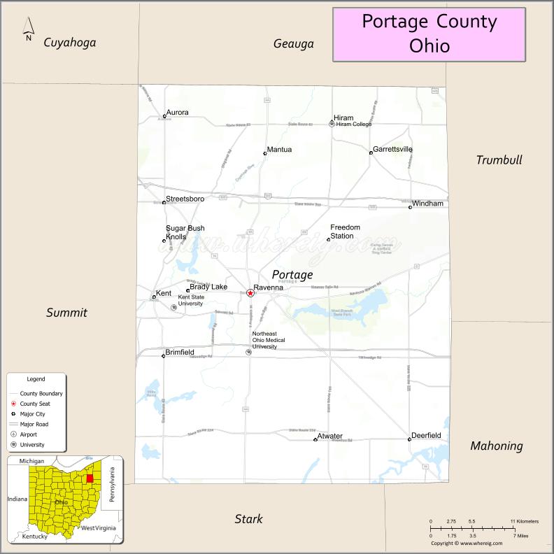
About Portage County Map, Ohio: The map showing the county boundary, county seat, major cities, highways, water bodies and neighbouring counties.
Ohio More Maps & Info
About Portage County, Ohio
Portage County is a county located in the U.S. state of Ohio. It's county seat is Ravenna. As per 2020 census, the population of Portage County is 162382 people and population density is square miles. According to the United States Census Bureau, the county has a total area of 492.39 sq mi (1,275 km2). Portage County was established on -33809.
Portage County Facts
| Continent | North America |
| Country | United States |
| State | Ohio |
| County Seat | Ravenna |
| Largest City/Town | Kent |
| Established | June 9, 1808 |
| Total Area | 504 sq mi (1,305 sq km) |
| Land Area | 492 sq mi (1,274 sq km) |
| Water Area | 12 sq mi (31 sq km) |
| Population | 161,791 (Census 2020) |
| Population Density | 329 people per sq mi |
| Time Zone | Eastern Time Zone (ET) |
| Major Highways | I-76, I-80 (Ohio Turnpike), State Route 43, State Route 44, State Route 14 |
| Neighboring Counties | Geauga County, Trumbull County, Mahoning County, Stark County, Summit County |
| Famous For | Kent State University, parks, education and research |
| Top Attractions | Kent State University, West Branch State Park, Portage Lakes area, Aurora Farms Outlets |
| Official Website | https://www.portagecounty-oh.gov/ |
Cities and Towns in Portage County, Ohio
- Ravenna (county seat) – 11,724 (Census 2020)
- Kent – 27,378 (Census 2020)
- Aurora – 17,239 (Census 2020)
- Streetsboro – 17,260 (Census 2020)
Roads and Highways in Portage County, Ohio
Portage County is well connected by highways that link it to Akron, Cleveland, and northeastern Ohio.
- I-76 – major east-west interstate connecting Akron to Youngstown
- I-80 (Ohio Turnpike) – toll road providing fast travel across northern Ohio
- State Route 43 – north-south route connecting Kent to Ravenna and beyond
- State Route 44 – connects Ravenna to Geauga and Summit counties
- State Route 14 – runs east-west linking the county to Salem and Akron
Neighboring Counties of Portage County
- Geauga County (north)
- Trumbull County (east)
- Mahoning County (southeast)
- Stark County (south)
- Summit County (west)
Top Attractions in Portage County, Ohio
Portage County offers parks, educational institutions, and shopping destinations.
- Kent State University – major public university with cultural and academic events
- West Branch State Park – large park with boating, camping, and hiking
- Aurora Farms Premium Outlets – popular shopping destination
- Portage Hike and Bike Trail – scenic trail for biking and walking
- Ravenna Historic District – downtown area with shops and history
- Headwaters Trail – recreational trail connecting several communities
- Berlin Lake nearby – popular for fishing and boating
- Streetsboro parks – local parks with green space and recreation
Distance from Portage County to Nearby Cities
- Portage County to Akron – 20 mi (32 km)
- Portage County to Cleveland – 40 mi (64 km)
- Portage County to Youngstown – 45 mi (72 km)
- Portage County to Canton – 35 mi (56 km)
- Portage County to Columbus – 130 mi (209 km)
FAQs about Portage County
Portage County is located in northeastern Ohio.
It is known for Kent State University, parks, and educational institutions.
The population was 161,791 according to the 2020 Census.
The county seat is Ravenna.
Yes, the county offers parks, trails, and shopping destinations.
- Adams County Map
- Allen County Map
- Ashland County Map
- Ashtabula County Map
- Athens County Map
- Auglaize County Map
- Belmont County Map
- Brown County Map
- Butler County Map
- Carroll County Map
- Champaign County Map
- Clark County Map
- Clermont County Map
- Clinton County Map
- Columbiana County Map
- Coshocton County Map
- Crawford County Map
- Cuyahoga County Map
- Darke County Map
- Defiance County Map
- Delaware County Map
- Erie County Map
- Fairfield County Map
- Fayette County Map
- Franklin County Map
- Fulton County Map
- Gallia County Map
- Geauga County Map
- Greene County Map
- Guernsey County Map
- Hamilton County Map
- Hancock County Map
- Hardin County Map
- Harrison County Map
- Henry County Map
- Highland County Map
- Hocking County Map
- Holmes County Map
- Huron County Map
- Jackson County Map
- Jefferson County Map
- Knox County Map
- Lake County Map
- Lawrence County Map
- Licking County Map
- Logan County Map
- Lorain County Map
- Lucas County Map
- Madison County Map
- Mahoning County Map
- Marion County Map
- Medina County Map
- Meigs County Map
- Mercer County Map
- Miami County Map
- Monroe County Map
- Montgomery County Map
- Morgan County Map
- Morrow County Map
- Muskingum County Map
- Noble County Map
- Ottawa County Map
- Paulding County Map
- Perry County Map
- Pickaway County Map
- Pike County Map
- Portage County Map
- Preble County Map
- Putnam County Map
- Richland County Map
- Ross County Map
- Sandusky County Map
- Scioto County Map
- Seneca County Map
- Shelby County Map
- Stark County Map
- Summit County Map
- Trumbull County Map
- Tuscarawas County Map
- Union County Map
- Van Wert County Map
- Vinton County Map
- Warren County Map
- Washington County Map
- Wayne County Map
- Williams County Map
- Wood County Map
- Wyandot County Map
- Alabama Counties
- Alaska boroughs
- Arizona Counties
- Arkansas Counties
- California County Map
- Colorado Counties
- Connecticut Counties
- Delaware Counties
- Florida County Map
- Georgia County Map
- Hawaii Counties
- Idaho Counties
- Illinois Counties
- Indiana Counties
- Iowa Counties
- Kansas Counties
- Kentucky Counties
- Louisiana Counties
- Maine Counties
- Maryland Counties
- Massachusetts Counties
- Michigan County Map
- Minnesota Counties
- Mississippi Counties
- Missouri Counties
- Montana Counties
- Nebraska Counties
- Nevada Counties
- New York Counties
- New Hampshire Counties
- New Jersey Counties
- New Mexico Counties
- North Carolina Counties
- North Dakota Counties
- Ohio County Map
- Oklahoma Counties
- Oregon Counties
- Pennsylvania Counties
- Rhode Island Counties
- South Carolina Counties
- South Dakota Counties
- Map of Tennessee
- Texas County Map
- Utah Counties
- Vermont Counties
- Virginia Counties
- Washington Counties
- West Virginia Counties
- Wisconsin Counties
- Wyoming Counties