Map of Butler County - Butler County is a county located in the U.S. state of Ohio. Butler County Map showing cities, highways, important places and water bodies. Get Where is Butler County located in the map, major cities in Butler county, population, areas, and places of interest.
Map of Butler County, Ohio
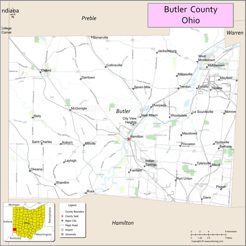
About Butler County Map, Ohio: The map showing the county boundary, county seat, major cities, highways, water bodies and neighbouring counties.
Ohio More Maps & Info
About Butler County, Ohio
Butler County is a county located in the U.S. state of Ohio. It's county seat is Hamilton. As per 2020 census, the population of Butler County is 390234 people and population density is square miles. According to the United States Census Bureau, the county has a total area of 467.27 sq mi (1,210 km2). Butler County was established on -35307.
Butler County Facts
| Continent | North America |
| Country | United States |
| State | Ohio |
| County Seat | Hamilton |
| Largest City/Town | Hamilton |
| Established | 1803 |
| Total Area | 470 sq mi |
| Land Area | 467 sq mi |
| Water Area | 3 sq mi |
| Population | 390,357 (Census 2020) |
| Population Density | 836 people per sq mi |
| Time Zone | Eastern Time Zone (ET) |
| Major Highways | I-75, US-27, SR-4, SR-129 |
| Neighboring Counties | Preble County, Montgomery County, Warren County, Hamilton County, Clermont County (KY border nearby) |
| Famous For | Miami University, historic towns, manufacturing heritage |
| Top Attractions | Miami University, Hueston Woods State Park, Pyramid Hill Sculpture Park |
| Official Website | https://www.butlercountyohio.org |
Cities and Towns in Butler County, Ohio
- Hamilton (county seat) – 62,477 (Census 2020)
- Middletown – 50,987 (Census 2020)
- Fairfield – 44,907 (Census 2020)
- Oxford – 23,035 (Census 2020)
Roads and Highways in Butler County, Ohio
Butler County has strong highway connections that link it to Cincinnati, Dayton, and other major areas in southwestern Ohio.
- Interstate 75 (I-75) – runs north-south connecting the county to Cincinnati (south) and Dayton (north)
- US Highway 27 – runs north-south connecting Oxford to Hamilton and further into Kentucky
- State Route 4 – connects Middletown to Hamilton and Springfield (north)
- State Route 129 – east-west route connecting Hamilton to I-75 and surrounding towns
Neighboring Counties of Butler County
- Preble County (northwest)
- Montgomery County (north)
- Warren County (east)
- Hamilton County (south)
- Franklin County, Indiana (west)
Top Attractions in Butler County, Ohio
Butler County offers a mix of outdoor recreation, cultural spots, and college-town energy.
- Miami University – historic campus known for its beautiful setting in Oxford
- Hueston Woods State Park – popular for hiking, camping, and boating
- Pyramid Hill Sculpture Park – outdoor art park with large sculptures and scenic trails
- Jungle Jim’s International Market – unique grocery destination with foods from around the world
- Fitton Center for Creative Arts – local hub for art exhibitions and performances
- Governor Bebb MetroPark – great spot for nature walks and picnics
- Smith Park – family-friendly park with sports fields and green space
- Oxford Community Arts Center – cultural venue with classes and exhibits
Distance from Butler County to Nearby Cities
- Hamilton to Cincinnati – 25 mi (40 km)
- Hamilton to Dayton – 35 mi (56 km)
- Hamilton to Columbus – 110 mi (177 km)
- Hamilton to Indianapolis – 120 mi (193 km)
- Hamilton to Lexington – 100 mi (161 km)
FAQs about Butler County
Butler County is located in southwestern Ohio, north of Cincinnati.
It is known for Miami University, outdoor parks, and its strong local communities.
The population was 390,357 according to the 2020 Census.
The county seat is Hamilton.
Top spots include Miami University, Hueston Woods State Park, and Pyramid Hill Sculpture Park.
- Adams County Map
- Allen County Map
- Ashland County Map
- Ashtabula County Map
- Athens County Map
- Auglaize County Map
- Belmont County Map
- Brown County Map
- Butler County Map
- Carroll County Map
- Champaign County Map
- Clark County Map
- Clermont County Map
- Clinton County Map
- Columbiana County Map
- Coshocton County Map
- Crawford County Map
- Cuyahoga County Map
- Darke County Map
- Defiance County Map
- Delaware County Map
- Erie County Map
- Fairfield County Map
- Fayette County Map
- Franklin County Map
- Fulton County Map
- Gallia County Map
- Geauga County Map
- Greene County Map
- Guernsey County Map
- Hamilton County Map
- Hancock County Map
- Hardin County Map
- Harrison County Map
- Henry County Map
- Highland County Map
- Hocking County Map
- Holmes County Map
- Huron County Map
- Jackson County Map
- Jefferson County Map
- Knox County Map
- Lake County Map
- Lawrence County Map
- Licking County Map
- Logan County Map
- Lorain County Map
- Lucas County Map
- Madison County Map
- Mahoning County Map
- Marion County Map
- Medina County Map
- Meigs County Map
- Mercer County Map
- Miami County Map
- Monroe County Map
- Montgomery County Map
- Morgan County Map
- Morrow County Map
- Muskingum County Map
- Noble County Map
- Ottawa County Map
- Paulding County Map
- Perry County Map
- Pickaway County Map
- Pike County Map
- Portage County Map
- Preble County Map
- Putnam County Map
- Richland County Map
- Ross County Map
- Sandusky County Map
- Scioto County Map
- Seneca County Map
- Shelby County Map
- Stark County Map
- Summit County Map
- Trumbull County Map
- Tuscarawas County Map
- Union County Map
- Van Wert County Map
- Vinton County Map
- Warren County Map
- Washington County Map
- Wayne County Map
- Williams County Map
- Wood County Map
- Wyandot County Map
- Alabama Counties
- Alaska boroughs
- Arizona Counties
- Arkansas Counties
- California County Map
- Colorado Counties
- Connecticut Counties
- Delaware Counties
- Florida County Map
- Georgia County Map
- Hawaii Counties
- Idaho Counties
- Illinois Counties
- Indiana Counties
- Iowa Counties
- Kansas Counties
- Kentucky Counties
- Louisiana Counties
- Maine Counties
- Maryland Counties
- Massachusetts Counties
- Michigan County Map
- Minnesota Counties
- Mississippi Counties
- Missouri Counties
- Montana Counties
- Nebraska Counties
- Nevada Counties
- New York Counties
- New Hampshire Counties
- New Jersey Counties
- New Mexico Counties
- North Carolina Counties
- North Dakota Counties
- Ohio County Map
- Oklahoma Counties
- Oregon Counties
- Pennsylvania Counties
- Rhode Island Counties
- South Carolina Counties
- South Dakota Counties
- Map of Tennessee
- Texas County Map
- Utah Counties
- Vermont Counties
- Virginia Counties
- Washington Counties
- West Virginia Counties
- Wisconsin Counties
- Wyoming Counties