Map of Vinton County - Vinton County is a county located in the U.S. state of Ohio. Vinton County Map showing cities, highways, important places and water bodies. Get Where is Vinton County located in the map, major cities in Vinton county, population, areas, and places of interest.
Map of Vinton County, Ohio
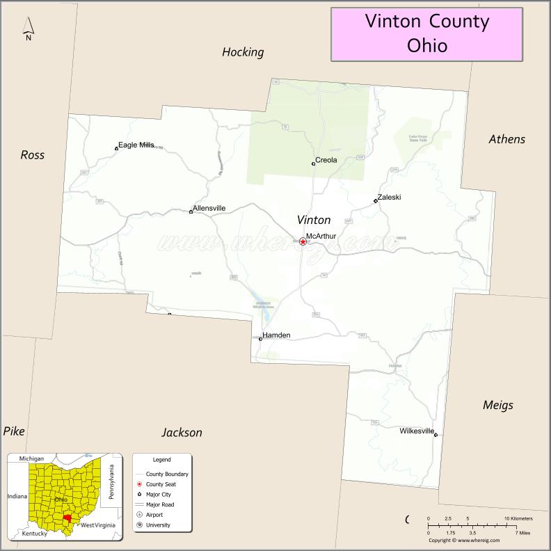
About Vinton County Map, Ohio: The map showing the county boundary, county seat, major cities, highways, water bodies and neighbouring counties.
Ohio More Maps & Info
About Vinton County, Ohio
Vinton County is a county located in the U.S. state of Ohio. It's county seat is McArthur. As per 2020 census, the population of Vinton County is 12696 people and population density is square miles. According to the United States Census Bureau, the county has a total area of 414.08 sq mi (1,072 km2). Vinton County was established on -18179.
Vinton County Facts
| Continent | North America |
| Country | United States |
| State | Ohio |
| County Seat | McArthur |
| Largest City/Town | McArthur |
| Established | March 23, 1850 |
| Total Area | 415 sq mi (1,075 sq km) |
| Land Area | 412 sq mi (1,067 sq km) |
| Water Area | 3.2 sq mi (8.3 sq km) |
| Population | 12,800 (Census 2020) |
| Population Density | 31 people per sq mi |
| Time Zone | Eastern Time Zone (ET) |
| Major Highways | US-50, State Route 93, State Route 278, State Route 324 |
| Neighboring Counties | Ross County, Hocking County, Athens County, Jackson County, Pike County |
| Famous For | Zaleski State Forest, rural Appalachian landscapes, outdoor recreation |
| Top Attractions | Zaleski State Forest, Lake Hope State Park, Vinton County Museum, Moonville Rail Trail |
| Official Website | https://www.vintoncounty.com/ |
Cities and Towns in Vinton County, Ohio
- McArthur (county seat) – 1,701 (Census 2020)
- Hamden – 815 (Census 2020)
- Wilkesville – 149 (Census 2020)
- Allensville – small unincorporated community
Roads and Highways in Vinton County, Ohio
Vinton County is served by scenic highways that pass through heavily forested Appalachian terrain.
- US-50 – east-west route connecting the county to Chillicothe and Athens
- State Route 93 – major north-south route through the county
- State Route 278 – connects McArthur to Zaleski State Forest and nearby areas
- State Route 324 – links rural communities and forest areas
Neighboring Counties of Vinton County
- Ross County (north)
- Hocking County (northwest)
- Athens County (east)
- Jackson County (south)
- Pike County (west)
Top Attractions in Vinton County, Ohio
Vinton County is known for its forests, trails, and outdoor recreation.
- Zaleski State Forest – large forest area for hiking, camping, and wildlife viewing
- Lake Hope State Park – scenic lake surrounded by forested hills
- Moonville Rail Trail – historic trail with railroad history and tunnels
- Vinton County Museum – local history exhibits in McArthur
- Wildcat Hollow Trail – popular hiking destination in Wayne National Forest
- Hamden community parks – small recreational areas
- Rural Appalachian scenery – rolling hills and forest landscapes
- Wayne National Forest nearby – extensive outdoor recreation opportunities
Distance from Vinton County to Nearby Cities
- Vinton County to Athens – 30 mi (48 km)
- Vinton County to Chillicothe – 35 mi (56 km)
- Vinton County to Columbus – 70 mi (113 km)
- Vinton County to Huntington, WV – 90 mi (145 km)
- Vinton County to Cincinnati – 110 mi (177 km)
FAQs about Vinton County
Vinton County is located in southeastern Ohio.
It is known for Zaleski State Forest, Lake Hope State Park, and rural Appalachian landscapes.
The population was 12,800 according to the 2020 Census.
The county seat is McArthur.
Yes, Vinton County offers forests, parks, hiking trails, and outdoor recreation areas.
- Adams County Map
- Allen County Map
- Ashland County Map
- Ashtabula County Map
- Athens County Map
- Auglaize County Map
- Belmont County Map
- Brown County Map
- Butler County Map
- Carroll County Map
- Champaign County Map
- Clark County Map
- Clermont County Map
- Clinton County Map
- Columbiana County Map
- Coshocton County Map
- Crawford County Map
- Cuyahoga County Map
- Darke County Map
- Defiance County Map
- Delaware County Map
- Erie County Map
- Fairfield County Map
- Fayette County Map
- Franklin County Map
- Fulton County Map
- Gallia County Map
- Geauga County Map
- Greene County Map
- Guernsey County Map
- Hamilton County Map
- Hancock County Map
- Hardin County Map
- Harrison County Map
- Henry County Map
- Highland County Map
- Hocking County Map
- Holmes County Map
- Huron County Map
- Jackson County Map
- Jefferson County Map
- Knox County Map
- Lake County Map
- Lawrence County Map
- Licking County Map
- Logan County Map
- Lorain County Map
- Lucas County Map
- Madison County Map
- Mahoning County Map
- Marion County Map
- Medina County Map
- Meigs County Map
- Mercer County Map
- Miami County Map
- Monroe County Map
- Montgomery County Map
- Morgan County Map
- Morrow County Map
- Muskingum County Map
- Noble County Map
- Ottawa County Map
- Paulding County Map
- Perry County Map
- Pickaway County Map
- Pike County Map
- Portage County Map
- Preble County Map
- Putnam County Map
- Richland County Map
- Ross County Map
- Sandusky County Map
- Scioto County Map
- Seneca County Map
- Shelby County Map
- Stark County Map
- Summit County Map
- Trumbull County Map
- Tuscarawas County Map
- Union County Map
- Van Wert County Map
- Vinton County Map
- Warren County Map
- Washington County Map
- Wayne County Map
- Williams County Map
- Wood County Map
- Wyandot County Map
- Alabama Counties
- Alaska boroughs
- Arizona Counties
- Arkansas Counties
- California County Map
- Colorado Counties
- Connecticut Counties
- Delaware Counties
- Florida County Map
- Georgia County Map
- Hawaii Counties
- Idaho Counties
- Illinois Counties
- Indiana Counties
- Iowa Counties
- Kansas Counties
- Kentucky Counties
- Louisiana Counties
- Maine Counties
- Maryland Counties
- Massachusetts Counties
- Michigan County Map
- Minnesota Counties
- Mississippi Counties
- Missouri Counties
- Montana Counties
- Nebraska Counties
- Nevada Counties
- New York Counties
- New Hampshire Counties
- New Jersey Counties
- New Mexico Counties
- North Carolina Counties
- North Dakota Counties
- Ohio County Map
- Oklahoma Counties
- Oregon Counties
- Pennsylvania Counties
- Rhode Island Counties
- South Carolina Counties
- South Dakota Counties
- Map of Tennessee
- Texas County Map
- Utah Counties
- Vermont Counties
- Virginia Counties
- Washington Counties
- West Virginia Counties
- Wisconsin Counties
- Wyoming Counties