Map of Crawford County - Crawford County is a county located in the U.S. state of Ohio. Crawford County Map showing cities, highways, important places and water bodies. Get Where is Crawford County located in the map, major cities in Crawford county, population, areas, and places of interest.
Map of Crawford County, Ohio
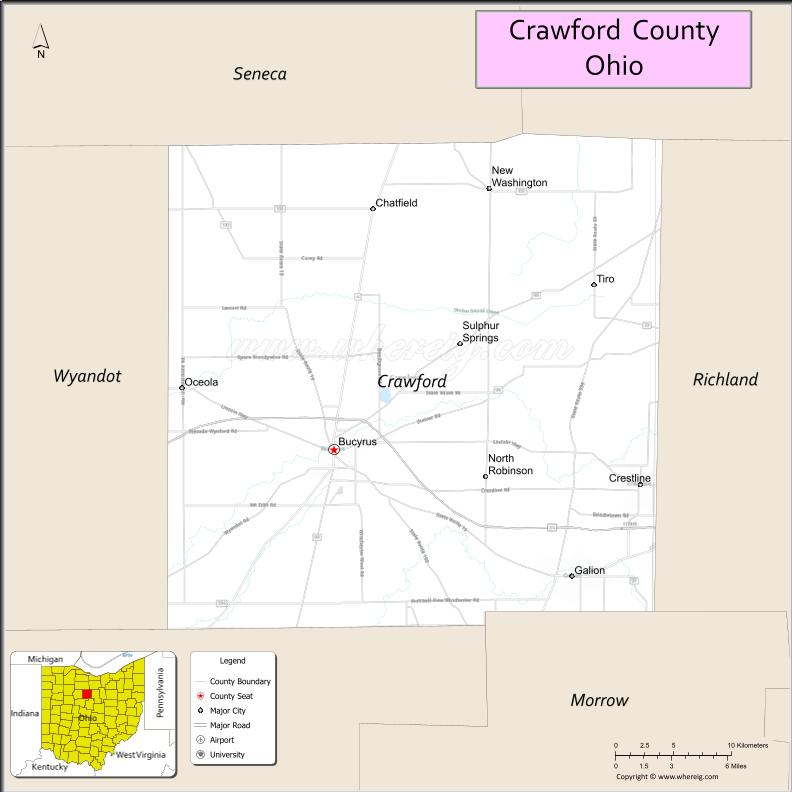
About Crawford County Map, Ohio: The map showing the county boundary, county seat, major cities, highways, water bodies and neighbouring counties.
Ohio More Maps & Info
About Crawford County, Ohio
Crawford County is a county located in the U.S. state of Ohio. It's county seat is Bucyrus. As per 2020 census, the population of Crawford County is 41754 people and population density is square miles. According to the United States Census Bureau, the county has a total area of 402.11 sq mi (1,041 km2). Crawford County was established on -29127.
Crawford County Facts
| Continent | North America |
| Country | United States |
| State | Ohio |
| County Seat | Bucyrus |
| Largest City/Town | Bucyrus |
| Established | 1820 |
| Total Area | 403 sq mi |
| Land Area | 402 sq mi |
| Water Area | 1 sq mi |
| Population | 42,025 (Census 2020) |
| Population Density | 104 people per sq mi |
| Time Zone | Eastern Time Zone (ET) |
| Major Highways | US-30, US-23, SR-4, SR-98 |
| Neighboring Counties | Seneca County, Huron County, Richland County, Morrow County, Marion County, Wyandot County |
| Famous For | Agriculture, Bucyrus bratwurst, manufacturing history |
| Top Attractions | Aumiller Park, Crawford Park District, Sears Woods State Nature Preserve |
| Official Website | https://www.crawford-co.org |
Cities and Towns in Crawford County, Ohio
- Bucyrus (county seat) – 11,684 (Census 2020)
- Galion (partly in county) – 10,453 (Census 2020)
- Crestline (partly in county) – 4,525 (Census 2020)
- New Washington – 967 (Census 2020)
Roads and Highways in Crawford County, Ohio
Crawford County is connected by key highways that link it to central and northern Ohio regions.
- US Highway 30 – runs east-west connecting Bucyrus to Mansfield (east) and Upper Sandusky (west)
- US Highway 23 – runs north-south connecting the county to Toledo (north) and Columbus (south)
- State Route 4 – connects Bucyrus to Sandusky (north) and Marion (south)
- State Route 98 – runs north-south connecting Bucyrus to Tiffin (north) and Galion (south)
Neighboring Counties of Crawford County
- Seneca County (north)
- Huron County (northwest)
- Richland County (east)
- Morrow County (south)
- Marion County (southwest)
- Wyandot County (west)
Top Attractions in Crawford County, Ohio
Crawford County offers parks, local history, and small-town attractions with a relaxed atmosphere.
- Aumiller Park – popular local park with trails, playgrounds, and picnic areas
- Crawford Park District – offers nature trails, educational programs, and wildlife viewing
- Sears Woods State Nature Preserve – protected woodland area with rare plant species
- Bucyrus Bratwurst Festival – annual event celebrating the city’s famous bratwurst
- Galion Historical Society – preserves local history and historic buildings
- Lowe-Volk Park – scenic park with a nature center and walking trails
- Sandusky River – provides opportunities for fishing and kayaking
- Heise Park – quiet community park with open green space
Distance from Crawford County to Nearby Cities
- Bucyrus to Columbus – 70 mi (113 km)
- Bucyrus to Toledo – 85 mi (137 km)
- Bucyrus to Cleveland – 100 mi (161 km)
- Bucyrus to Mansfield – 25 mi (40 km)
- Bucyrus to Sandusky – 60 mi (97 km)
FAQs about Crawford County
Crawford County is located in north-central Ohio.
It is known for its agricultural roots, Bucyrus bratwurst, and manufacturing history.
The population was 42,025 according to the 2020 Census.
The county seat is Bucyrus.
Top attractions include Aumiller Park, Crawford Park District, and Sears Woods State Nature Preserve.
- Adams County Map
- Allen County Map
- Ashland County Map
- Ashtabula County Map
- Athens County Map
- Auglaize County Map
- Belmont County Map
- Brown County Map
- Butler County Map
- Carroll County Map
- Champaign County Map
- Clark County Map
- Clermont County Map
- Clinton County Map
- Columbiana County Map
- Coshocton County Map
- Crawford County Map
- Cuyahoga County Map
- Darke County Map
- Defiance County Map
- Delaware County Map
- Erie County Map
- Fairfield County Map
- Fayette County Map
- Franklin County Map
- Fulton County Map
- Gallia County Map
- Geauga County Map
- Greene County Map
- Guernsey County Map
- Hamilton County Map
- Hancock County Map
- Hardin County Map
- Harrison County Map
- Henry County Map
- Highland County Map
- Hocking County Map
- Holmes County Map
- Huron County Map
- Jackson County Map
- Jefferson County Map
- Knox County Map
- Lake County Map
- Lawrence County Map
- Licking County Map
- Logan County Map
- Lorain County Map
- Lucas County Map
- Madison County Map
- Mahoning County Map
- Marion County Map
- Medina County Map
- Meigs County Map
- Mercer County Map
- Miami County Map
- Monroe County Map
- Montgomery County Map
- Morgan County Map
- Morrow County Map
- Muskingum County Map
- Noble County Map
- Ottawa County Map
- Paulding County Map
- Perry County Map
- Pickaway County Map
- Pike County Map
- Portage County Map
- Preble County Map
- Putnam County Map
- Richland County Map
- Ross County Map
- Sandusky County Map
- Scioto County Map
- Seneca County Map
- Shelby County Map
- Stark County Map
- Summit County Map
- Trumbull County Map
- Tuscarawas County Map
- Union County Map
- Van Wert County Map
- Vinton County Map
- Warren County Map
- Washington County Map
- Wayne County Map
- Williams County Map
- Wood County Map
- Wyandot County Map
- Alabama Counties
- Alaska boroughs
- Arizona Counties
- Arkansas Counties
- California County Map
- Colorado Counties
- Connecticut Counties
- Delaware Counties
- Florida County Map
- Georgia County Map
- Hawaii Counties
- Idaho Counties
- Illinois Counties
- Indiana Counties
- Iowa Counties
- Kansas Counties
- Kentucky Counties
- Louisiana Counties
- Maine Counties
- Maryland Counties
- Massachusetts Counties
- Michigan County Map
- Minnesota Counties
- Mississippi Counties
- Missouri Counties
- Montana Counties
- Nebraska Counties
- Nevada Counties
- New York Counties
- New Hampshire Counties
- New Jersey Counties
- New Mexico Counties
- North Carolina Counties
- North Dakota Counties
- Ohio County Map
- Oklahoma Counties
- Oregon Counties
- Pennsylvania Counties
- Rhode Island Counties
- South Carolina Counties
- South Dakota Counties
- Map of Tennessee
- Texas County Map
- Utah Counties
- Vermont Counties
- Virginia Counties
- Washington Counties
- West Virginia Counties
- Wisconsin Counties
- Wyoming Counties