Map of Harrison County - Harrison County is a county located in the U.S. state of Ohio. Harrison County Map showing cities, highways, important places and water bodies. Get Where is Harrison County located in the map, major cities in Harrison county, population, areas, and places of interest.
Map of Harrison County, Ohio
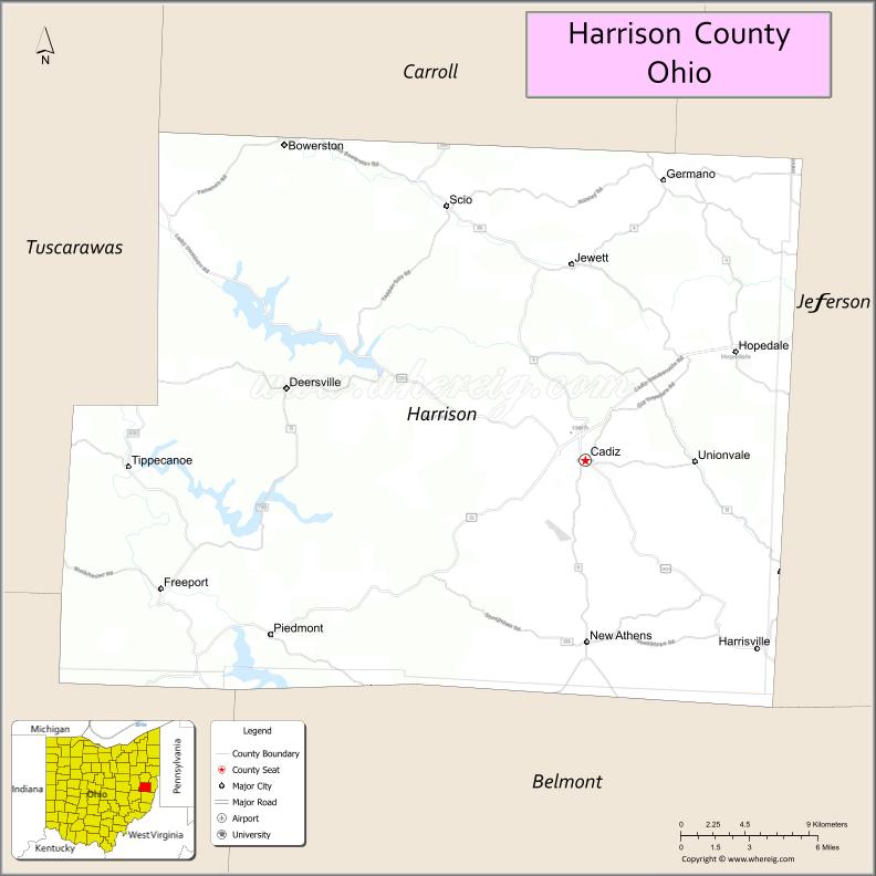
About Harrison County Map, Ohio: The map showing the county boundary, county seat, major cities, highways, water bodies and neighbouring counties.
Ohio More Maps & Info
About Harrison County, Ohio
Harrison County is a county located in the U.S. state of Ohio. It's county seat is Cadiz. As per 2020 census, the population of Harrison County is 14477 people and population density is square miles. According to the United States Census Bureau, the county has a total area of 403.53 sq mi (1,045 km2). Harrison County was established on -31743.
Harrison County Facts
| Continent | North America |
| Country | United States |
| State | Ohio |
| County Seat | Cadiz |
| Largest City/Town | Cadiz |
| Established | February 1, 1813 |
| Total Area | 411 sq mi (1,065 sq km) |
| Land Area | 410 sq mi (1,062 sq km) |
| Water Area | 1.3 sq mi (3.4 sq km) |
| Population | 14,483 (Census 2020) |
| Population Density | 35 people per sq mi |
| Time Zone | Eastern Time Zone (ET) |
| Major Highways | US-22, State Route 9, State Route 151, State Route 250, State Route 519 |
| Neighboring Counties | Jefferson County, Carroll County, Tuscarawas County, Belmont County, Guernsey County |
| Famous For | Coal mining history, rural Appalachian landscape, oil and gas production |
| Top Attractions | Clark Gable Foundation, Sally Buffalo Park, Tappan Lake, Harrison County Courthouse |
| Official Website | https://www.harrisoncountyohio.org/ |
Cities and Towns in Harrison County, Ohio
- Cadiz (county seat) – 3,052 (Census 2020)
- Hopedale – 892 (Census 2020)
- Scio – 674 (Census 2020)
- Deersville – 82 (Census 2020)
Roads and Highways in Harrison County, Ohio
Harrison County is served by key highways that connect it to eastern Ohio and nearby communities.
- US-22 – major east-west route linking Cadiz to Cambridge and Steubenville
- State Route 9 – north-south route connecting the county to Carrollton and Belmont County
- State Route 151 – runs through Cadiz connecting to Tuscarawas County
- State Route 250 – connects the county to Wheeling, West Virginia and Uhrichsville
- State Route 519 – links Cadiz to surrounding rural areas
Neighboring Counties of Harrison County
- Jefferson County (east)
- Belmont County (south)
- Guernsey County (southwest)
- Tuscarawas County (northwest)
- Carroll County (north)
Top Attractions in Harrison County, Ohio
Harrison County offers scenic countryside, historic sites, and outdoor recreation.
- Clark Gable Foundation – museum dedicated to the famous actor born in the county
- Sally Buffalo Park – popular park with a lake, trails, and picnic areas
- Tappan Lake Park – great spot for boating, fishing, and camping
- Harrison County Courthouse – historic landmark in Cadiz
- Conotton Creek Trail – scenic area for walking and nature viewing
- Deersville General Store – historic small-town landmark
- Scio Pottery Museum – showcases local pottery history
- Local Amish communities – offer handmade goods and traditional lifestyle
Distance from Harrison County to Nearby Cities
- Harrison County to Steubenville – 25 mi (40 km)
- Harrison County to Cambridge – 20 mi (32 km)
- Harrison County to Wheeling – 30 mi (48 km)
- Harrison County to Columbus – 110 mi (177 km)
- Harrison County to Pittsburgh – 65 mi (105 km)
FAQs about Harrison County
Harrison County is located in eastern Ohio.
It is known for its coal mining history, rural landscape, and oil and gas production.
The population was 14,483 according to the 2020 Census.
The county seat is Cadiz.
Yes, the county has parks, lakes, and scenic outdoor areas.
- Adams County Map
- Allen County Map
- Ashland County Map
- Ashtabula County Map
- Athens County Map
- Auglaize County Map
- Belmont County Map
- Brown County Map
- Butler County Map
- Carroll County Map
- Champaign County Map
- Clark County Map
- Clermont County Map
- Clinton County Map
- Columbiana County Map
- Coshocton County Map
- Crawford County Map
- Cuyahoga County Map
- Darke County Map
- Defiance County Map
- Delaware County Map
- Erie County Map
- Fairfield County Map
- Fayette County Map
- Franklin County Map
- Fulton County Map
- Gallia County Map
- Geauga County Map
- Greene County Map
- Guernsey County Map
- Hamilton County Map
- Hancock County Map
- Hardin County Map
- Harrison County Map
- Henry County Map
- Highland County Map
- Hocking County Map
- Holmes County Map
- Huron County Map
- Jackson County Map
- Jefferson County Map
- Knox County Map
- Lake County Map
- Lawrence County Map
- Licking County Map
- Logan County Map
- Lorain County Map
- Lucas County Map
- Madison County Map
- Mahoning County Map
- Marion County Map
- Medina County Map
- Meigs County Map
- Mercer County Map
- Miami County Map
- Monroe County Map
- Montgomery County Map
- Morgan County Map
- Morrow County Map
- Muskingum County Map
- Noble County Map
- Ottawa County Map
- Paulding County Map
- Perry County Map
- Pickaway County Map
- Pike County Map
- Portage County Map
- Preble County Map
- Putnam County Map
- Richland County Map
- Ross County Map
- Sandusky County Map
- Scioto County Map
- Seneca County Map
- Shelby County Map
- Stark County Map
- Summit County Map
- Trumbull County Map
- Tuscarawas County Map
- Union County Map
- Van Wert County Map
- Vinton County Map
- Warren County Map
- Washington County Map
- Wayne County Map
- Williams County Map
- Wood County Map
- Wyandot County Map
- Alabama Counties
- Alaska boroughs
- Arizona Counties
- Arkansas Counties
- California County Map
- Colorado Counties
- Connecticut Counties
- Delaware Counties
- Florida County Map
- Georgia County Map
- Hawaii Counties
- Idaho Counties
- Illinois Counties
- Indiana Counties
- Iowa Counties
- Kansas Counties
- Kentucky Counties
- Louisiana Counties
- Maine Counties
- Maryland Counties
- Massachusetts Counties
- Michigan County Map
- Minnesota Counties
- Mississippi Counties
- Missouri Counties
- Montana Counties
- Nebraska Counties
- Nevada Counties
- New York Counties
- New Hampshire Counties
- New Jersey Counties
- New Mexico Counties
- North Carolina Counties
- North Dakota Counties
- Ohio County Map
- Oklahoma Counties
- Oregon Counties
- Pennsylvania Counties
- Rhode Island Counties
- South Carolina Counties
- South Dakota Counties
- Map of Tennessee
- Texas County Map
- Utah Counties
- Vermont Counties
- Virginia Counties
- Washington Counties
- West Virginia Counties
- Wisconsin Counties
- Wyoming Counties