Map of Mahoning County - Mahoning County is a county located in the U.S. state of Ohio. Mahoning County Map showing cities, highways, important places and water bodies. Get Where is Mahoning County located in the map, major cities in Mahoning county, population, areas, and places of interest.
Map of Mahoning County, Ohio
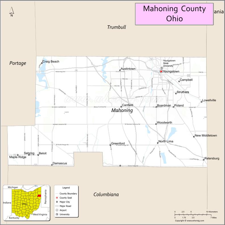
About Mahoning County Map, Ohio: The map showing the county boundary, county seat, major cities, highways, water bodies and neighbouring counties.
Ohio More Maps & Info
About Mahoning County, Ohio
Mahoning County is a county located in the U.S. state of Ohio. It's county seat is Youngstown. As per 2020 census, the population of Mahoning County is 226762 people and population density is square miles. According to the United States Census Bureau, the county has a total area of 415.25 sq mi (1,075 km2). Mahoning County was established on -19662.
Mahoning County Facts
| Continent | North America |
| Country | United States |
| State | Ohio |
| County Seat | Youngstown |
| Largest City/Town | Youngstown |
| Established | March 1, 1846 |
| Total Area | 425 sq mi (1,101 sq km) |
| Land Area | 411 sq mi (1,064 sq km) |
| Water Area | 14 sq mi (36 sq km) |
| Population | 228,614 (Census 2020) |
| Population Density | 556 people per sq mi |
| Time Zone | Eastern Time Zone (ET) |
| Major Highways | I-76, I-680, US-62, State Route 11, State Route 7 |
| Neighboring Counties | Trumbull County, Columbiana County, Portage County, Stark County |
| Famous For | Steel industry history, Youngstown, parks and cultural sites |
| Top Attractions | Mill Creek Park, Butler Institute of American Art, Fellows Riverside Gardens, Lanterman’s Mill |
| Official Website | https://www.mahoningcountyoh.gov/ |
Cities and Towns in Mahoning County, Ohio
- Youngstown (county seat) – 60,068 (Census 2020)
- Boardman – 40,213 (Census 2020)
- Austintown – 29,439 (Census 2020)
- Struthers – 10,926 (Census 2020)
Roads and Highways in Mahoning County, Ohio
Mahoning County is served by major highways that connect it to northeastern Ohio and western Pennsylvania.
- I-76 – major east-west interstate linking Youngstown to Akron and Pennsylvania
- I-680 – loop route connecting Youngstown to surrounding suburbs
- US-62 – runs east-west connecting Youngstown to Warren and Alliance
- State Route 11 – north-south highway connecting Youngstown to Ashtabula and East Liverpool
- State Route 7 – runs along eastern parts of the county near the Pennsylvania border
Neighboring Counties of Mahoning County
- Trumbull County (north)
- Portage County (west)
- Stark County (southwest)
- Columbiana County (south)
Top Attractions in Mahoning County, Ohio
Mahoning County offers parks, cultural attractions, and historic sites centered around Youngstown.
- Mill Creek Park – large urban park with lakes, trails, and gardens
- Fellows Riverside Gardens – scenic garden with walking paths and seasonal displays
- Butler Institute of American Art – museum featuring American artwork
- Lanterman’s Mill – historic gristmill with scenic surroundings
- Youngstown Historical Center of Industry and Labor – museum highlighting industrial history
- Covelli Centre – venue for sports and entertainment events
- Boardman Park – popular community park with recreational facilities
- Arms Family Museum – historic home showcasing local heritage
Distance from Mahoning County to Nearby Cities
- Mahoning County to Cleveland – 70 mi (113 km)
- Mahoning County to Pittsburgh – 65 mi (105 km)
- Mahoning County to Akron – 45 mi (72 km)
- Mahoning County to Columbus – 150 mi (241 km)
- Mahoning County to Erie – 90 mi (145 km)
FAQs about Mahoning County
Mahoning County is located in northeastern Ohio near the Pennsylvania border.
It is known for its steel industry history, parks, and cultural attractions.
The population was 228,614 according to the 2020 Census.
The county seat is Youngstown.
Yes, the county has parks, museums, and historic landmarks.
- Adams County Map
- Allen County Map
- Ashland County Map
- Ashtabula County Map
- Athens County Map
- Auglaize County Map
- Belmont County Map
- Brown County Map
- Butler County Map
- Carroll County Map
- Champaign County Map
- Clark County Map
- Clermont County Map
- Clinton County Map
- Columbiana County Map
- Coshocton County Map
- Crawford County Map
- Cuyahoga County Map
- Darke County Map
- Defiance County Map
- Delaware County Map
- Erie County Map
- Fairfield County Map
- Fayette County Map
- Franklin County Map
- Fulton County Map
- Gallia County Map
- Geauga County Map
- Greene County Map
- Guernsey County Map
- Hamilton County Map
- Hancock County Map
- Hardin County Map
- Harrison County Map
- Henry County Map
- Highland County Map
- Hocking County Map
- Holmes County Map
- Huron County Map
- Jackson County Map
- Jefferson County Map
- Knox County Map
- Lake County Map
- Lawrence County Map
- Licking County Map
- Logan County Map
- Lorain County Map
- Lucas County Map
- Madison County Map
- Mahoning County Map
- Marion County Map
- Medina County Map
- Meigs County Map
- Mercer County Map
- Miami County Map
- Monroe County Map
- Montgomery County Map
- Morgan County Map
- Morrow County Map
- Muskingum County Map
- Noble County Map
- Ottawa County Map
- Paulding County Map
- Perry County Map
- Pickaway County Map
- Pike County Map
- Portage County Map
- Preble County Map
- Putnam County Map
- Richland County Map
- Ross County Map
- Sandusky County Map
- Scioto County Map
- Seneca County Map
- Shelby County Map
- Stark County Map
- Summit County Map
- Trumbull County Map
- Tuscarawas County Map
- Union County Map
- Van Wert County Map
- Vinton County Map
- Warren County Map
- Washington County Map
- Wayne County Map
- Williams County Map
- Wood County Map
- Wyandot County Map
- Alabama Counties
- Alaska boroughs
- Arizona Counties
- Arkansas Counties
- California County Map
- Colorado Counties
- Connecticut Counties
- Delaware Counties
- Florida County Map
- Georgia County Map
- Hawaii Counties
- Idaho Counties
- Illinois Counties
- Indiana Counties
- Iowa Counties
- Kansas Counties
- Kentucky Counties
- Louisiana Counties
- Maine Counties
- Maryland Counties
- Massachusetts Counties
- Michigan County Map
- Minnesota Counties
- Mississippi Counties
- Missouri Counties
- Montana Counties
- Nebraska Counties
- Nevada Counties
- New York Counties
- New Hampshire Counties
- New Jersey Counties
- New Mexico Counties
- North Carolina Counties
- North Dakota Counties
- Ohio County Map
- Oklahoma Counties
- Oregon Counties
- Pennsylvania Counties
- Rhode Island Counties
- South Carolina Counties
- South Dakota Counties
- Map of Tennessee
- Texas County Map
- Utah Counties
- Vermont Counties
- Virginia Counties
- Washington Counties
- West Virginia Counties
- Wisconsin Counties
- Wyoming Counties