Map of Coshocton County - Coshocton County is a county located in the U.S. state of Ohio. Coshocton County Map showing cities, highways, important places and water bodies. Get Where is Coshocton County located in the map, major cities in Coshocton county, population, areas, and places of interest.
Map of Coshocton County, Ohio
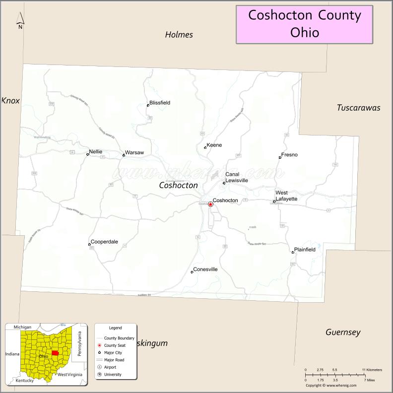
About Coshocton County Map, Ohio: The map showing the county boundary, county seat, major cities, highways, water bodies and neighbouring counties.
Ohio More Maps & Info
About Coshocton County, Ohio
Coshocton County is a county located in the U.S. state of Ohio. It's county seat is Coshocton. As per 2020 census, the population of Coshocton County is 36618 people and population density is square miles. According to the United States Census Bureau, the county has a total area of 564.07 sq mi (1,461 km2). Coshocton County was established on -32840.
Coshocton County Facts
| Continent | North America |
| Country | United States |
| State | Ohio |
| County Seat | Coshocton |
| Largest City/Town | Coshocton |
| Established | 1811 |
| Total Area | 567 sq mi |
| Land Area | 564 sq mi |
| Water Area | 3 sq mi |
| Population | 36,612 (Census 2020) |
| Population Density | 65 people per sq mi |
| Time Zone | Eastern Time Zone (ET) |
| Major Highways | US-36, US-62, SR-16, SR-60, SR-541 |
| Neighboring Counties | Holmes County, Tuscarawas County, Guernsey County, Muskingum County, Knox County, Licking County |
| Famous For | Historic canal era, Roscoe Village, scenic countryside |
| Top Attractions | Roscoe Village, Coshocton Lake Park, Historic Canal Museum |
| Official Website | https://www.coshoctoncounty.net |
Cities and Towns in Coshocton County, Ohio
- Coshocton (county seat) – 10,847 (Census 2020)
- West Lafayette – 2,321 (Census 2020)
- Baltic (partly in county) – 795 (Census 2020)
- Warsaw – 674 (Census 2020)
Roads and Highways in Coshocton County, Ohio
Coshocton County is served by several highways that connect it to central and eastern Ohio communities.
- US Highway 36 – runs east-west connecting Coshocton to Newark (west) and Uhrichsville (east)
- US Highway 62 – runs north-south connecting Coshocton to Millersburg (north) and Zanesville (south)
- State Route 16 – connects Coshocton to Newark and Columbus (west)
- State Route 60 – runs north-south connecting the county to Loudonville (north) and Marietta (south)
- State Route 541 – connects Coshocton to Martinsburg and surrounding rural areas
Neighboring Counties of Coshocton County
- Holmes County (north)
- Tuscarawas County (east)
- Guernsey County (southeast)
- Muskingum County (south)
- Licking County (southwest)
- Knox County (west)
Top Attractions in Coshocton County, Ohio
Coshocton County features historic sites, scenic views, and outdoor recreation tied to its canal-era past.
- Roscoe Village – restored canal town with shops, restaurants, and museums
- Coshocton Lake Park – popular for fishing, walking, and picnicking
- Historic Canal Museum – highlights the region’s canal history
- Clary Gardens – peaceful botanical garden with walking paths and seasonal blooms
- Three Rivers Wine Trail – local wineries offering tastings and scenic views
- Johnson-Humrickhouse Museum – exhibits on local history and global artifacts
- Woodbury Wildlife Area (nearby) – large area for hunting, fishing, and hiking
- Lake Park Pavilion – community gathering spot with river views
Distance from Coshocton County to Nearby Cities
- Coshocton to Columbus – 70 mi (113 km)
- Coshocton to Zanesville – 30 mi (48 km)
- Coshocton to Newark – 40 mi (64 km)
- Coshocton to Canton – 60 mi (97 km)
- Coshocton to Cleveland – 100 mi (161 km)
FAQs about Coshocton County
Coshocton County is located in east-central Ohio.
It is known for Roscoe Village, canal-era history, and scenic countryside.
The population was 36,612 according to the 2020 Census.
The county seat is Coshocton.
Top attractions include Roscoe Village, Coshocton Lake Park, and the Historic Canal Museum.
- Adams County Map
- Allen County Map
- Ashland County Map
- Ashtabula County Map
- Athens County Map
- Auglaize County Map
- Belmont County Map
- Brown County Map
- Butler County Map
- Carroll County Map
- Champaign County Map
- Clark County Map
- Clermont County Map
- Clinton County Map
- Columbiana County Map
- Coshocton County Map
- Crawford County Map
- Cuyahoga County Map
- Darke County Map
- Defiance County Map
- Delaware County Map
- Erie County Map
- Fairfield County Map
- Fayette County Map
- Franklin County Map
- Fulton County Map
- Gallia County Map
- Geauga County Map
- Greene County Map
- Guernsey County Map
- Hamilton County Map
- Hancock County Map
- Hardin County Map
- Harrison County Map
- Henry County Map
- Highland County Map
- Hocking County Map
- Holmes County Map
- Huron County Map
- Jackson County Map
- Jefferson County Map
- Knox County Map
- Lake County Map
- Lawrence County Map
- Licking County Map
- Logan County Map
- Lorain County Map
- Lucas County Map
- Madison County Map
- Mahoning County Map
- Marion County Map
- Medina County Map
- Meigs County Map
- Mercer County Map
- Miami County Map
- Monroe County Map
- Montgomery County Map
- Morgan County Map
- Morrow County Map
- Muskingum County Map
- Noble County Map
- Ottawa County Map
- Paulding County Map
- Perry County Map
- Pickaway County Map
- Pike County Map
- Portage County Map
- Preble County Map
- Putnam County Map
- Richland County Map
- Ross County Map
- Sandusky County Map
- Scioto County Map
- Seneca County Map
- Shelby County Map
- Stark County Map
- Summit County Map
- Trumbull County Map
- Tuscarawas County Map
- Union County Map
- Van Wert County Map
- Vinton County Map
- Warren County Map
- Washington County Map
- Wayne County Map
- Williams County Map
- Wood County Map
- Wyandot County Map
- Alabama Counties
- Alaska boroughs
- Arizona Counties
- Arkansas Counties
- California County Map
- Colorado Counties
- Connecticut Counties
- Delaware Counties
- Florida County Map
- Georgia County Map
- Hawaii Counties
- Idaho Counties
- Illinois Counties
- Indiana Counties
- Iowa Counties
- Kansas Counties
- Kentucky Counties
- Louisiana Counties
- Maine Counties
- Maryland Counties
- Massachusetts Counties
- Michigan County Map
- Minnesota Counties
- Mississippi Counties
- Missouri Counties
- Montana Counties
- Nebraska Counties
- Nevada Counties
- New York Counties
- New Hampshire Counties
- New Jersey Counties
- New Mexico Counties
- North Carolina Counties
- North Dakota Counties
- Ohio County Map
- Oklahoma Counties
- Oregon Counties
- Pennsylvania Counties
- Rhode Island Counties
- South Carolina Counties
- South Dakota Counties
- Map of Tennessee
- Texas County Map
- Utah Counties
- Vermont Counties
- Virginia Counties
- Washington Counties
- West Virginia Counties
- Wisconsin Counties
- Wyoming Counties