Map of Belmont County - Belmont County is a county located in the U.S. state of Ohio. Belmont County Map showing cities, highways, important places and water bodies. Get Where is Belmont County located in the map, major cities in Belmont county, population, areas, and places of interest.
Map of Belmont County, Ohio
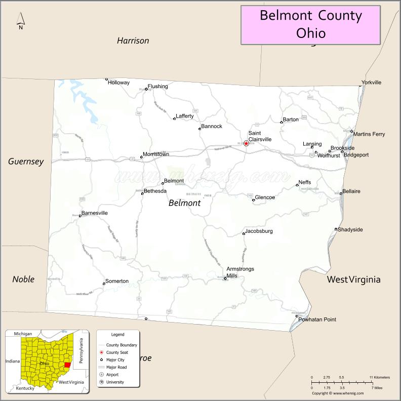
About Belmont County Map, Ohio: The map showing the county boundary, county seat, major cities, highways, water bodies and neighbouring counties.
Ohio More Maps & Info
About Belmont County, Ohio
Belmont County is a county located in the U.S. state of Ohio. It's county seat is St. Clairsville. As per 2020 census, the population of Belmont County is 65849 people and population density is square miles. According to the United States Census Bureau, the county has a total area of 537.35 sq mi (1,392 km2). Belmont County was established on -35908.
Belmont County Facts
| Continent | North America |
| Country | United States |
| State | Ohio |
| County Seat | St. Clairsville |
| Largest City/Town | Martins Ferry |
| Established | 1801 |
| Total Area | 537 sq mi |
| Land Area | 532 sq mi |
| Water Area | 5 sq mi |
| Population | 66,497 (Census 2020) |
| Population Density | 125 people per sq mi |
| Time Zone | Eastern (EST) |
| Major Highways | I-70, US-40, US-22, I-470 |
| Neighboring Counties | Harrison County (OH), Guernsey County (OH), Monroe County (OH), Washington County (PA), Marshall County (WV), Ohio County (WV) |
| Famous For | Ohio River valley, coal mining history, Appalachian heritage |
| Top Attractions | Barkcamp State Park, Belmont County Heritage Museum, Ohio Valley Mall area |
| Official Website | https://belmontcountyohio.org |
Cities and Towns in Belmont County, Ohio
- St. Clairsville (county seat) – 5,115 (Census 2020)
- Martins Ferry – 6,260 (Census 2020)
- Bellaire – 3,869 (Census 2020)
- Bridgeport – 1,930 (Census 2020)
Roads and Highways in Belmont County, Ohio
Belmont County is a key transportation corridor in eastern Ohio, connecting the state to West Virginia and Pennsylvania.
- Interstate 70 (I-70) – Major east-west interstate connecting Columbus and Wheeling, WV
- Interstate 470 (I-470) – Bypass route around Wheeling, WV serving the county
- U.S. Route 40 (US-40) – Historic National Road passing through the county
- U.S. Route 22 (US-22) – Connects the county to Steubenville and Pennsylvania
Neighboring Counties of Belmont County
- Harrison County (north)
- Guernsey County (west)
- Monroe County (south)
- Washington County, Pennsylvania (east)
- Marshall County, West Virginia (southeast)
- Ohio County, West Virginia (south)
Top Attractions in Belmont County, Ohio
Belmont County offers river views, parks, and historic Appalachian landmarks.
- Barkcamp State Park – Lake, camping, and hiking trails
- Belmont County Heritage Museum – Local history exhibits
- Ohio River Scenic Byway – Scenic driving route along the river
- Hannibal Locks and Dam – Engineering landmark on the Ohio River
- National Road Heritage Area – Historic transportation corridor
- St. Clairsville Historic Downtown – Shops, restaurants, and historic buildings
- Belmont Hills Country Club – Golf and recreation facility
Distance from Belmont County to Nearby Cities
- St. Clairsville to Columbus – 125 mi (201 km)
- St. Clairsville to Pittsburgh, PA – 75 mi (121 km)
- St. Clairsville to Wheeling, WV – 10 mi (16 km)
- St. Clairsville to Cleveland – 140 mi (225 km)
- St. Clairsville to Cincinnati – 190 mi (306 km)
FAQs about Belmont County
Belmont County is known for its Ohio River valley, coal mining history, and Appalachian heritage.
St. Clairsville is the county seat of Belmont County.
Yes, Belmont County borders West Virginia along the Ohio River.
Visitors enjoy Barkcamp State Park, the Ohio River Scenic Byway, and historic downtown St. Clairsville.
Yes, Belmont County is part of the Appalachian region of southeastern Ohio.
- Adams County Map
- Allen County Map
- Ashland County Map
- Ashtabula County Map
- Athens County Map
- Auglaize County Map
- Belmont County Map
- Brown County Map
- Butler County Map
- Carroll County Map
- Champaign County Map
- Clark County Map
- Clermont County Map
- Clinton County Map
- Columbiana County Map
- Coshocton County Map
- Crawford County Map
- Cuyahoga County Map
- Darke County Map
- Defiance County Map
- Delaware County Map
- Erie County Map
- Fairfield County Map
- Fayette County Map
- Franklin County Map
- Fulton County Map
- Gallia County Map
- Geauga County Map
- Greene County Map
- Guernsey County Map
- Hamilton County Map
- Hancock County Map
- Hardin County Map
- Harrison County Map
- Henry County Map
- Highland County Map
- Hocking County Map
- Holmes County Map
- Huron County Map
- Jackson County Map
- Jefferson County Map
- Knox County Map
- Lake County Map
- Lawrence County Map
- Licking County Map
- Logan County Map
- Lorain County Map
- Lucas County Map
- Madison County Map
- Mahoning County Map
- Marion County Map
- Medina County Map
- Meigs County Map
- Mercer County Map
- Miami County Map
- Monroe County Map
- Montgomery County Map
- Morgan County Map
- Morrow County Map
- Muskingum County Map
- Noble County Map
- Ottawa County Map
- Paulding County Map
- Perry County Map
- Pickaway County Map
- Pike County Map
- Portage County Map
- Preble County Map
- Putnam County Map
- Richland County Map
- Ross County Map
- Sandusky County Map
- Scioto County Map
- Seneca County Map
- Shelby County Map
- Stark County Map
- Summit County Map
- Trumbull County Map
- Tuscarawas County Map
- Union County Map
- Van Wert County Map
- Vinton County Map
- Warren County Map
- Washington County Map
- Wayne County Map
- Williams County Map
- Wood County Map
- Wyandot County Map
- Alabama Counties
- Alaska boroughs
- Arizona Counties
- Arkansas Counties
- California County Map
- Colorado Counties
- Connecticut Counties
- Delaware Counties
- Florida County Map
- Georgia County Map
- Hawaii Counties
- Idaho Counties
- Illinois Counties
- Indiana Counties
- Iowa Counties
- Kansas Counties
- Kentucky Counties
- Louisiana Counties
- Maine Counties
- Maryland Counties
- Massachusetts Counties
- Michigan County Map
- Minnesota Counties
- Mississippi Counties
- Missouri Counties
- Montana Counties
- Nebraska Counties
- Nevada Counties
- New York Counties
- New Hampshire Counties
- New Jersey Counties
- New Mexico Counties
- North Carolina Counties
- North Dakota Counties
- Ohio County Map
- Oklahoma Counties
- Oregon Counties
- Pennsylvania Counties
- Rhode Island Counties
- South Carolina Counties
- South Dakota Counties
- Map of Tennessee
- Texas County Map
- Utah Counties
- Vermont Counties
- Virginia Counties
- Washington Counties
- West Virginia Counties
- Wisconsin Counties
- Wyoming Counties