Map of Morgan County - Morgan County is a county located in the U.S. state of Ohio. Morgan County Map showing cities, highways, important places and water bodies. Get Where is Morgan County located in the map, major cities in Morgan county, population, areas, and places of interest.
Map of Morgan County, Ohio
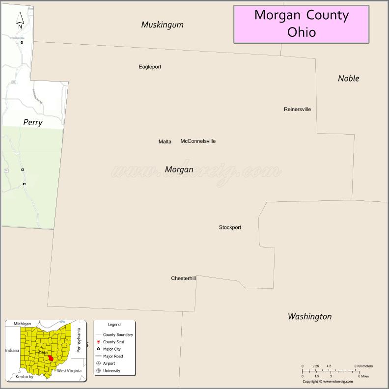
About Morgan County Map, Ohio: The map showing the county boundary, county seat, major cities, highways, water bodies and neighbouring counties.
Ohio More Maps & Info
About Morgan County, Ohio
Morgan County is a county located in the U.S. state of Ohio. It's county seat is McConnelsville. As per 2020 census, the population of Morgan County is 13682 people and population density is square miles. According to the United States Census Bureau, the county has a total area of 417.66 sq mi (1,082 km2). Morgan County was established on -29951.
Morgan County Facts
| Continent | North America |
| Country | United States |
| State | Ohio |
| County Seat | McConnelsville |
| Largest City/Town | McConnelsville |
| Established | December 29, 1817 |
| Total Area | 422 sq mi (1,093 sq km) |
| Land Area | 418 sq mi (1,082 sq km) |
| Water Area | 4.0 sq mi (10.4 sq km) |
| Population | 14,508 (Census 2020) |
| Population Density | 35 people per sq mi |
| Time Zone | Eastern Time Zone (ET) |
| Major Highways | State Route 37, State Route 60, State Route 78, State Route 377 |
| Neighboring Counties | Muskingum County, Noble County, Washington County, Athens County, Perry County |
| Famous For | Appalachian scenery, rural landscapes, historic small towns |
| Top Attractions | Burr Oak State Park, Morgan County Historical Society, Twin City Opera House, Muskingum River |
| Official Website | https://morgancounty-oh.gov/ |
Cities and Towns in Morgan County, Ohio
- McConnelsville (county seat) – 1,784 (Census 2020)
- Malta – 671 (Census 2020)
- Chesterhill – 287 (Census 2020)
- Stockport – 503 (Census 2020)
Roads and Highways in Morgan County, Ohio
Morgan County is connected by scenic routes that run through southeastern Ohio’s rolling hills and countryside.
- State Route 37 – connects McConnelsville to Lancaster and southeastern Ohio
- State Route 60 – runs north-south along the Muskingum River through the county
- State Route 78 – scenic east-west route known for its winding Appalachian views
- State Route 377 – links McConnelsville to Malta and surrounding communities
Neighboring Counties of Morgan County
- Muskingum County (north)
- Noble County (east)
- Washington County (south)
- Athens County (southwest)
- Perry County (west)
Top Attractions in Morgan County, Ohio
Morgan County offers outdoor recreation, scenic views, and historic charm.
- Burr Oak State Park – popular for camping, boating, and hiking
- Muskingum River – scenic waterway for boating and fishing
- Twin City Opera House – historic theater with local performances
- Morgan County Historical Society – museum showcasing local history
- McConnelsville Historic District – charming downtown with historic buildings
- Stockport Mill – historic mill along the river
- Chesterhill area – quiet rural setting with scenic views
- Malta Riverfront – peaceful spot for relaxing by the water
Distance from Morgan County to Nearby Cities
- Morgan County to Zanesville – 25 mi (40 km)
- Morgan County to Athens – 35 mi (56 km)
- Morgan County to Marietta – 40 mi (64 km)
- Morgan County to Columbus – 75 mi (121 km)
- Morgan County to Parkersburg – 45 mi (72 km)
FAQs about Morgan County
Morgan County is located in southeastern Ohio.
It is known for its Appalachian scenery, rural landscapes, and historic small towns.
The population was 14,508 according to the 2020 Census.
The county seat is McConnelsville.
Yes, the county offers parks, rivers, and scenic countryside.
- Adams County Map
- Allen County Map
- Ashland County Map
- Ashtabula County Map
- Athens County Map
- Auglaize County Map
- Belmont County Map
- Brown County Map
- Butler County Map
- Carroll County Map
- Champaign County Map
- Clark County Map
- Clermont County Map
- Clinton County Map
- Columbiana County Map
- Coshocton County Map
- Crawford County Map
- Cuyahoga County Map
- Darke County Map
- Defiance County Map
- Delaware County Map
- Erie County Map
- Fairfield County Map
- Fayette County Map
- Franklin County Map
- Fulton County Map
- Gallia County Map
- Geauga County Map
- Greene County Map
- Guernsey County Map
- Hamilton County Map
- Hancock County Map
- Hardin County Map
- Harrison County Map
- Henry County Map
- Highland County Map
- Hocking County Map
- Holmes County Map
- Huron County Map
- Jackson County Map
- Jefferson County Map
- Knox County Map
- Lake County Map
- Lawrence County Map
- Licking County Map
- Logan County Map
- Lorain County Map
- Lucas County Map
- Madison County Map
- Mahoning County Map
- Marion County Map
- Medina County Map
- Meigs County Map
- Mercer County Map
- Miami County Map
- Monroe County Map
- Montgomery County Map
- Morgan County Map
- Morrow County Map
- Muskingum County Map
- Noble County Map
- Ottawa County Map
- Paulding County Map
- Perry County Map
- Pickaway County Map
- Pike County Map
- Portage County Map
- Preble County Map
- Putnam County Map
- Richland County Map
- Ross County Map
- Sandusky County Map
- Scioto County Map
- Seneca County Map
- Shelby County Map
- Stark County Map
- Summit County Map
- Trumbull County Map
- Tuscarawas County Map
- Union County Map
- Van Wert County Map
- Vinton County Map
- Warren County Map
- Washington County Map
- Wayne County Map
- Williams County Map
- Wood County Map
- Wyandot County Map
- Alabama Counties
- Alaska boroughs
- Arizona Counties
- Arkansas Counties
- California County Map
- Colorado Counties
- Connecticut Counties
- Delaware Counties
- Florida County Map
- Georgia County Map
- Hawaii Counties
- Idaho Counties
- Illinois Counties
- Indiana Counties
- Iowa Counties
- Kansas Counties
- Kentucky Counties
- Louisiana Counties
- Maine Counties
- Maryland Counties
- Massachusetts Counties
- Michigan County Map
- Minnesota Counties
- Mississippi Counties
- Missouri Counties
- Montana Counties
- Nebraska Counties
- Nevada Counties
- New York Counties
- New Hampshire Counties
- New Jersey Counties
- New Mexico Counties
- North Carolina Counties
- North Dakota Counties
- Ohio County Map
- Oklahoma Counties
- Oregon Counties
- Pennsylvania Counties
- Rhode Island Counties
- South Carolina Counties
- South Dakota Counties
- Map of Tennessee
- Texas County Map
- Utah Counties
- Vermont Counties
- Virginia Counties
- Washington Counties
- West Virginia Counties
- Wisconsin Counties
- Wyoming Counties