Map of Mercer County - Mercer County is a county located in the U.S. state of Ohio. Mercer County Map showing cities, highways, important places and water bodies. Get Where is Mercer County located in the map, major cities in Mercer county, population, areas, and places of interest.
Map of Mercer County, Ohio
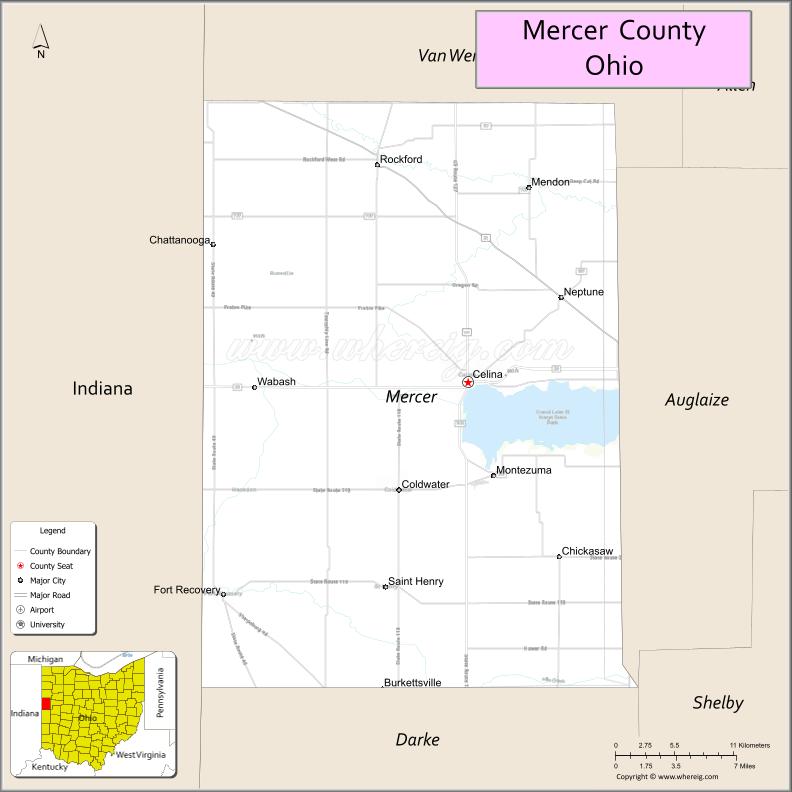
About Mercer County Map, Ohio: The map showing the county boundary, county seat, major cities, highways, water bodies and neighbouring counties.
Ohio More Maps & Info
About Mercer County, Ohio
Mercer County is a county located in the U.S. state of Ohio. It's county seat is Celina. As per 2020 census, the population of Mercer County is 42309 people and population density is square miles. According to the United States Census Bureau, the county has a total area of 463.27 sq mi (1,200 km2). Mercer County was established on -29127.
Mercer County Facts
| Continent | North America |
| Country | United States |
| State | Ohio |
| County Seat | Celina |
| Largest City/Town | Celina |
| Established | April 1, 1820 |
| Total Area | 469 sq mi (1,215 sq km) |
| Land Area | 462 sq mi (1,197 sq km) |
| Water Area | 7.5 sq mi (19.4 sq km) |
| Population | 42,528 (Census 2020) |
| Population Density | 92 people per sq mi |
| Time Zone | Eastern Time Zone (ET) |
| Major Highways | US-127, State Route 29, State Route 49, State Route 118, State Route 219 |
| Neighboring Counties | Darke County, Auglaize County, Van Wert County, Jay County (IN), Adams County (IN) |
| Famous For | Grand Lake St. Marys, agriculture, boating and fishing |
| Top Attractions | Grand Lake St. Marys State Park, Celina Lakefront, Mercer County Fairgrounds, Coldwater Historic District |
| Official Website | https://www.mercercountyohio.org/ |
Cities and Towns in Mercer County, Ohio
- Celina (county seat) – 10,935 (Census 2020)
- Coldwater – 4,774 (Census 2020)
- St. Henry – 2,822 (Census 2020)
- Rockford – 1,051 (Census 2020)
Roads and Highways in Mercer County, Ohio
Mercer County is connected by highways that link it to western Ohio and eastern Indiana.
- US-127 – major north-south route connecting Celina to Van Wert and Greenville
- State Route 29 – east-west highway linking Celina to Sidney and Decatur, Indiana
- State Route 49 – runs north-south connecting the county to Darke County and Indiana
- State Route 118 – links Celina to St. Marys and surrounding communities
- State Route 219 – connects Celina to Coldwater and eastern areas
Neighboring Counties of Mercer County
- Van Wert County (north)
- Auglaize County (east)
- Darke County (south)
- Jay County, Indiana (west)
- Adams County, Indiana (northwest)
Top Attractions in Mercer County, Ohio
Mercer County is known for its lakeside recreation, small towns, and outdoor activities.
- Grand Lake St. Marys State Park – popular for boating, fishing, and camping
- Celina Lakefront – scenic area with parks, walking paths, and events
- Coldwater Historic District – charming area with local shops and heritage
- Mercer County Fairgrounds – hosts one of Ohio’s largest county fairs
- St. Henry Community Park – local park with recreational facilities
- Windy Point Park – lakeside park with camping and picnicking
- Shanes Park – community park with sports fields and green space
- Lake Improvement Association areas – scenic spots around Grand Lake
Distance from Mercer County to Nearby Cities
- Mercer County to Lima – 35 mi (56 km)
- Mercer County to Dayton – 75 mi (121 km)
- Mercer County to Fort Wayne – 50 mi (80 km)
- Mercer County to Columbus – 110 mi (177 km)
- Mercer County to Toledo – 110 mi (177 km)
FAQs about Mercer County
Mercer County is located in western Ohio along the Indiana border.
It is known for Grand Lake St. Marys, agriculture, and outdoor recreation.
The population was 42,528 according to the 2020 Census.
The county seat is Celina.
Yes, the county offers lakes, parks, and community events.
- Adams County Map
- Allen County Map
- Ashland County Map
- Ashtabula County Map
- Athens County Map
- Auglaize County Map
- Belmont County Map
- Brown County Map
- Butler County Map
- Carroll County Map
- Champaign County Map
- Clark County Map
- Clermont County Map
- Clinton County Map
- Columbiana County Map
- Coshocton County Map
- Crawford County Map
- Cuyahoga County Map
- Darke County Map
- Defiance County Map
- Delaware County Map
- Erie County Map
- Fairfield County Map
- Fayette County Map
- Franklin County Map
- Fulton County Map
- Gallia County Map
- Geauga County Map
- Greene County Map
- Guernsey County Map
- Hamilton County Map
- Hancock County Map
- Hardin County Map
- Harrison County Map
- Henry County Map
- Highland County Map
- Hocking County Map
- Holmes County Map
- Huron County Map
- Jackson County Map
- Jefferson County Map
- Knox County Map
- Lake County Map
- Lawrence County Map
- Licking County Map
- Logan County Map
- Lorain County Map
- Lucas County Map
- Madison County Map
- Mahoning County Map
- Marion County Map
- Medina County Map
- Meigs County Map
- Mercer County Map
- Miami County Map
- Monroe County Map
- Montgomery County Map
- Morgan County Map
- Morrow County Map
- Muskingum County Map
- Noble County Map
- Ottawa County Map
- Paulding County Map
- Perry County Map
- Pickaway County Map
- Pike County Map
- Portage County Map
- Preble County Map
- Putnam County Map
- Richland County Map
- Ross County Map
- Sandusky County Map
- Scioto County Map
- Seneca County Map
- Shelby County Map
- Stark County Map
- Summit County Map
- Trumbull County Map
- Tuscarawas County Map
- Union County Map
- Van Wert County Map
- Vinton County Map
- Warren County Map
- Washington County Map
- Wayne County Map
- Williams County Map
- Wood County Map
- Wyandot County Map
- Alabama Counties
- Alaska boroughs
- Arizona Counties
- Arkansas Counties
- California County Map
- Colorado Counties
- Connecticut Counties
- Delaware Counties
- Florida County Map
- Georgia County Map
- Hawaii Counties
- Idaho Counties
- Illinois Counties
- Indiana Counties
- Iowa Counties
- Kansas Counties
- Kentucky Counties
- Louisiana Counties
- Maine Counties
- Maryland Counties
- Massachusetts Counties
- Michigan County Map
- Minnesota Counties
- Mississippi Counties
- Missouri Counties
- Montana Counties
- Nebraska Counties
- Nevada Counties
- New York Counties
- New Hampshire Counties
- New Jersey Counties
- New Mexico Counties
- North Carolina Counties
- North Dakota Counties
- Ohio County Map
- Oklahoma Counties
- Oregon Counties
- Pennsylvania Counties
- Rhode Island Counties
- South Carolina Counties
- South Dakota Counties
- Map of Tennessee
- Texas County Map
- Utah Counties
- Vermont Counties
- Virginia Counties
- Washington Counties
- West Virginia Counties
- Wisconsin Counties
- Wyoming Counties