Map of Licking County - Licking County is a county located in the U.S. state of Ohio. Licking County Map showing cities, highways, important places and water bodies. Get Where is Licking County located in the map, major cities in Licking county, population, areas, and places of interest.
Map of Licking County, Ohio
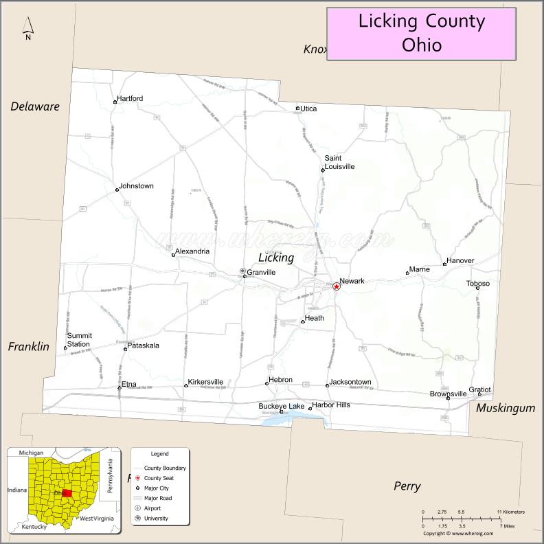
About Licking County Map, Ohio: The map showing the county boundary, county seat, major cities, highways, water bodies and neighbouring counties.
Ohio More Maps & Info
About Licking County, Ohio
Licking County is a county located in the U.S. state of Ohio. It's county seat is Newark. As per 2020 census, the population of Licking County is 180401 people and population density is square miles. According to the United States Census Bureau, the county has a total area of 686.50 sq mi (1,778 km2). Licking County was established on -33541.
Licking County Facts
| Continent | North America |
| Country | United States |
| State | Ohio |
| County Seat | Newark |
| Largest City/Town | Newark |
| Established | March 1, 1808 |
| Total Area | 687 sq mi (1,779 sq km) |
| Land Area | 682 sq mi (1,766 sq km) |
| Water Area | 5.1 sq mi (13.2 sq km) |
| Population | 178,519 (Census 2020) |
| Population Density | 262 people per sq mi |
| Time Zone | Eastern Time Zone (ET) |
| Major Highways | I-70, US-40, State Route 16, State Route 79, State Route 13 |
| Neighboring Counties | Knox County, Coshocton County, Muskingum County, Perry County, Fairfield County, Franklin County, Delaware County |
| Famous For | Newark Earthworks, suburban Columbus growth, historic sites |
| Top Attractions | Newark Earthworks, Dawes Arboretum, Blackhand Gorge State Nature Preserve, Buckeye Lake |
| Official Website | https://www.lcounty.com/ |
Cities and Towns in Licking County, Ohio
- Newark (county seat) – 50,029 (Census 2020)
- Heath – 10,310 (Census 2020)
- Pataskala – 18,391 (Census 2020)
- Granville – 5,895 (Census 2020)
Roads and Highways in Licking County, Ohio
Licking County is served by major highways that connect it to Columbus and eastern Ohio.
- I-70 – major east-west interstate linking Columbus to Zanesville and beyond
- US-40 – historic route paralleling I-70 through the county
- State Route 16 – major expressway connecting Newark to Columbus
- State Route 79 – runs north-south linking Newark to Coshocton
- State Route 13 – connects the county to Mount Vernon and Lancaster
Neighboring Counties of Licking County
- Knox County (north)
- Coshocton County (northeast)
- Muskingum County (east)
- Perry County (south)
- Fairfield County (southwest)
- Franklin County (west)
- Delaware County (northwest)
Top Attractions in Licking County, Ohio
Licking County offers a mix of historic landmarks, nature areas, and growing suburban attractions.
- Newark Earthworks – ancient Native American earthworks and UNESCO site
- Dawes Arboretum – large arboretum with gardens, trails, and events
- Blackhand Gorge State Nature Preserve – scenic gorge with hiking and biking trails
- Buckeye Lake – popular destination for boating and fishing
- Denison University in Granville – historic campus with cultural events
- Historic Downtown Newark – shops, restaurants, and local history
- Granville Village – charming town with boutiques and dining
- Infirmary Mound Park – park with trails, disc golf, and nature areas
Distance from Licking County to Nearby Cities
- Licking County to Columbus – 30 mi (48 km)
- Licking County to Zanesville – 30 mi (48 km)
- Licking County to Newark (city center) – 0 mi (0 km)
- Licking County to Lancaster – 25 mi (40 km)
- Licking County to Cleveland – 120 mi (193 km)
FAQs about Licking County
Licking County is located in central Ohio, east of Columbus.
It is known for the Newark Earthworks, natural parks, and suburban growth near Columbus.
The population was 178,519 according to the 2020 Census.
The county seat is Newark.
Yes, the county has historic sites, parks, lakes, and cultural attractions.
- Adams County Map
- Allen County Map
- Ashland County Map
- Ashtabula County Map
- Athens County Map
- Auglaize County Map
- Belmont County Map
- Brown County Map
- Butler County Map
- Carroll County Map
- Champaign County Map
- Clark County Map
- Clermont County Map
- Clinton County Map
- Columbiana County Map
- Coshocton County Map
- Crawford County Map
- Cuyahoga County Map
- Darke County Map
- Defiance County Map
- Delaware County Map
- Erie County Map
- Fairfield County Map
- Fayette County Map
- Franklin County Map
- Fulton County Map
- Gallia County Map
- Geauga County Map
- Greene County Map
- Guernsey County Map
- Hamilton County Map
- Hancock County Map
- Hardin County Map
- Harrison County Map
- Henry County Map
- Highland County Map
- Hocking County Map
- Holmes County Map
- Huron County Map
- Jackson County Map
- Jefferson County Map
- Knox County Map
- Lake County Map
- Lawrence County Map
- Licking County Map
- Logan County Map
- Lorain County Map
- Lucas County Map
- Madison County Map
- Mahoning County Map
- Marion County Map
- Medina County Map
- Meigs County Map
- Mercer County Map
- Miami County Map
- Monroe County Map
- Montgomery County Map
- Morgan County Map
- Morrow County Map
- Muskingum County Map
- Noble County Map
- Ottawa County Map
- Paulding County Map
- Perry County Map
- Pickaway County Map
- Pike County Map
- Portage County Map
- Preble County Map
- Putnam County Map
- Richland County Map
- Ross County Map
- Sandusky County Map
- Scioto County Map
- Seneca County Map
- Shelby County Map
- Stark County Map
- Summit County Map
- Trumbull County Map
- Tuscarawas County Map
- Union County Map
- Van Wert County Map
- Vinton County Map
- Warren County Map
- Washington County Map
- Wayne County Map
- Williams County Map
- Wood County Map
- Wyandot County Map
- Alabama Counties
- Alaska boroughs
- Arizona Counties
- Arkansas Counties
- California County Map
- Colorado Counties
- Connecticut Counties
- Delaware Counties
- Florida County Map
- Georgia County Map
- Hawaii Counties
- Idaho Counties
- Illinois Counties
- Indiana Counties
- Iowa Counties
- Kansas Counties
- Kentucky Counties
- Louisiana Counties
- Maine Counties
- Maryland Counties
- Massachusetts Counties
- Michigan County Map
- Minnesota Counties
- Mississippi Counties
- Missouri Counties
- Montana Counties
- Nebraska Counties
- Nevada Counties
- New York Counties
- New Hampshire Counties
- New Jersey Counties
- New Mexico Counties
- North Carolina Counties
- North Dakota Counties
- Ohio County Map
- Oklahoma Counties
- Oregon Counties
- Pennsylvania Counties
- Rhode Island Counties
- South Carolina Counties
- South Dakota Counties
- Map of Tennessee
- Texas County Map
- Utah Counties
- Vermont Counties
- Virginia Counties
- Washington Counties
- West Virginia Counties
- Wisconsin Counties
- Wyoming Counties