Map of Pickaway County - Pickaway County is a county located in the U.S. state of Ohio. Pickaway County Map showing cities, highways, important places and water bodies. Get Where is Pickaway County located in the map, major cities in Pickaway county, population, areas, and places of interest.
Map of Pickaway County, Ohio
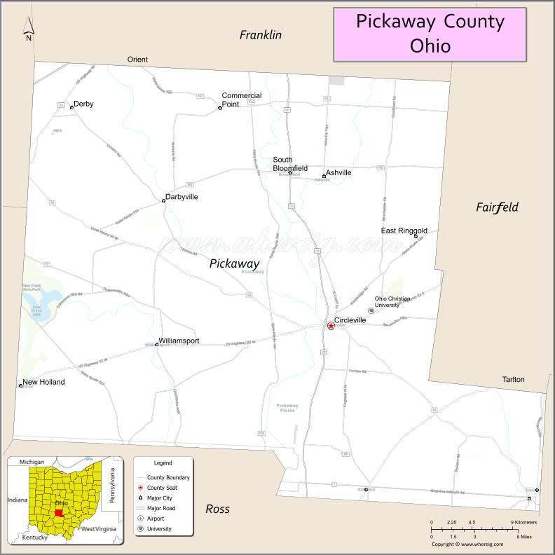
About Pickaway County Map, Ohio: The map showing the county boundary, county seat, major cities, highways, water bodies and neighbouring counties.
Ohio More Maps & Info
About Pickaway County, Ohio
Pickaway County is a county located in the U.S. state of Ohio. It's county seat is Circleville. As per 2020 census, the population of Pickaway County is 59333 people and population density is square miles. According to the United States Census Bureau, the county has a total area of 501.91 sq mi (1,300 km2). Pickaway County was established on -32811.
Pickaway County Facts
| Continent | North America |
| Country | United States |
| State | Ohio |
| County Seat | Circleville |
| Largest City/Town | Circleville |
| Established | March 1, 1810 |
| Total Area | 507 sq mi (1,313 sq km) |
| Land Area | 501 sq mi (1,298 sq km) |
| Water Area | 6.4 sq mi (16.6 sq km) |
| Population | 58,457 (Census 2020) |
| Population Density | 117 people per sq mi |
| Time Zone | Eastern Time Zone (ET) |
| Major Highways | US-23, State Route 104, State Route 56, State Route 22, State Route 762 |
| Neighboring Counties | Franklin County, Fairfield County, Hocking County, Ross County, Fayette County, Madison County |
| Famous For | Circleville Pumpkin Show, agriculture, Scioto River |
| Top Attractions | Circleville Pumpkin Show, A.W. Marion State Park, Pickaway County Fairgrounds, Scioto River |
| Official Website | https://www.pickaway.org/ |
Cities and Towns in Pickaway County, Ohio
- Circleville (county seat) – 14,188 (Census 2020)
- South Bloomfield – 2,386 (Census 2020)
- Ashville – 4,213 (Census 2020)
- Commercial Point – 2,582 (Census 2020)
Roads and Highways in Pickaway County, Ohio
Pickaway County is well connected by highways that provide access to Columbus and southern Ohio.
- US-23 – major north-south highway connecting Circleville to Columbus and Chillicothe
- State Route 104 – runs north-south linking the county to Columbus and Portsmouth
- State Route 56 – east-west route connecting Circleville to Athens and Hocking Hills
- State Route 22 – connects Circleville to Lancaster and Washington Court House
- State Route 762 – provides access between US-23 and surrounding communities
Neighboring Counties of Pickaway County
- Franklin County (north)
- Fairfield County (east)
- Hocking County (southeast)
- Ross County (south)
- Fayette County (west)
- Madison County (northwest)
Top Attractions in Pickaway County, Ohio
Pickaway County offers festivals, parks, and scenic countryside.
- Circleville Pumpkin Show – annual festival attracting visitors from across the country
- A.W. Marion State Park – popular for boating, fishing, and camping
- Pickaway County Fairgrounds – hosts events and agricultural fairs
- Scioto River – scenic river for fishing and outdoor activities
- Stage’s Pond State Nature Preserve – natural area with trails and wildlife
- Circleville Historic District – charming downtown with shops and history
- Smith Memorial Park – local park with recreational facilities
- Ashville community parks – green spaces for outdoor recreation
Distance from Pickaway County to Nearby Cities
- Pickaway County to Columbus – 25 mi (40 km)
- Pickaway County to Chillicothe – 25 mi (40 km)
- Pickaway County to Lancaster – 20 mi (32 km)
- Pickaway County to Dayton – 75 mi (121 km)
- Pickaway County to Cincinnati – 90 mi (145 km)
FAQs about Pickaway County
Pickaway County is located in central Ohio, south of Columbus.
It is known for the Circleville Pumpkin Show, agriculture, and scenic countryside.
The population was 58,457 according to the 2020 Census.
The county seat is Circleville.
Yes, the county offers festivals, parks, and outdoor recreation.
- Adams County Map
- Allen County Map
- Ashland County Map
- Ashtabula County Map
- Athens County Map
- Auglaize County Map
- Belmont County Map
- Brown County Map
- Butler County Map
- Carroll County Map
- Champaign County Map
- Clark County Map
- Clermont County Map
- Clinton County Map
- Columbiana County Map
- Coshocton County Map
- Crawford County Map
- Cuyahoga County Map
- Darke County Map
- Defiance County Map
- Delaware County Map
- Erie County Map
- Fairfield County Map
- Fayette County Map
- Franklin County Map
- Fulton County Map
- Gallia County Map
- Geauga County Map
- Greene County Map
- Guernsey County Map
- Hamilton County Map
- Hancock County Map
- Hardin County Map
- Harrison County Map
- Henry County Map
- Highland County Map
- Hocking County Map
- Holmes County Map
- Huron County Map
- Jackson County Map
- Jefferson County Map
- Knox County Map
- Lake County Map
- Lawrence County Map
- Licking County Map
- Logan County Map
- Lorain County Map
- Lucas County Map
- Madison County Map
- Mahoning County Map
- Marion County Map
- Medina County Map
- Meigs County Map
- Mercer County Map
- Miami County Map
- Monroe County Map
- Montgomery County Map
- Morgan County Map
- Morrow County Map
- Muskingum County Map
- Noble County Map
- Ottawa County Map
- Paulding County Map
- Perry County Map
- Pickaway County Map
- Pike County Map
- Portage County Map
- Preble County Map
- Putnam County Map
- Richland County Map
- Ross County Map
- Sandusky County Map
- Scioto County Map
- Seneca County Map
- Shelby County Map
- Stark County Map
- Summit County Map
- Trumbull County Map
- Tuscarawas County Map
- Union County Map
- Van Wert County Map
- Vinton County Map
- Warren County Map
- Washington County Map
- Wayne County Map
- Williams County Map
- Wood County Map
- Wyandot County Map
- Alabama Counties
- Alaska boroughs
- Arizona Counties
- Arkansas Counties
- California County Map
- Colorado Counties
- Connecticut Counties
- Delaware Counties
- Florida County Map
- Georgia County Map
- Hawaii Counties
- Idaho Counties
- Illinois Counties
- Indiana Counties
- Iowa Counties
- Kansas Counties
- Kentucky Counties
- Louisiana Counties
- Maine Counties
- Maryland Counties
- Massachusetts Counties
- Michigan County Map
- Minnesota Counties
- Mississippi Counties
- Missouri Counties
- Montana Counties
- Nebraska Counties
- Nevada Counties
- New York Counties
- New Hampshire Counties
- New Jersey Counties
- New Mexico Counties
- North Carolina Counties
- North Dakota Counties
- Ohio County Map
- Oklahoma Counties
- Oregon Counties
- Pennsylvania Counties
- Rhode Island Counties
- South Carolina Counties
- South Dakota Counties
- Map of Tennessee
- Texas County Map
- Utah Counties
- Vermont Counties
- Virginia Counties
- Washington Counties
- West Virginia Counties
- Wisconsin Counties
- Wyoming Counties