Map of Brown County - Brown County is a county located in the U.S. state of Ohio. Brown County Map showing cities, highways, important places and water bodies. Get Where is Brown County located in the map, major cities in Brown county, population, areas, and places of interest.
Map of Brown County, Ohio
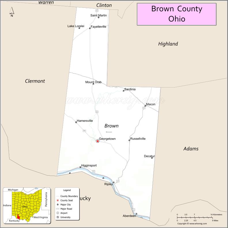
About Brown County Map, Ohio: The map showing the county boundary, county seat, major cities, highways, water bodies and neighbouring counties.
Ohio More Maps & Info
About Brown County, Ohio
Brown County is a county located in the U.S. state of Ohio. It's county seat is Georgetown. As per 2020 census, the population of Brown County is 43662 people and population density is square miles. According to the United States Census Bureau, the county has a total area of 491.76 sq mi (1,274 km2). Brown County was established on -29889.
Brown County Facts
| Continent | North America |
| Country | United States |
| State | Ohio |
| County Seat | Georgetown |
| Largest City/Town | Georgetown |
| Established | 1818 |
| Total Area | 493 sq mi |
| Land Area | 490 sq mi |
| Water Area | 3 sq mi |
| Population | 44,846 (Census 2020) |
| Population Density | 91 people per sq mi |
| Time Zone | Eastern Time Zone (ET) |
| Major Highways | US-52, US-68, SR-32, SR-125 |
| Neighboring Counties | Clermont County, Adams County, Highland County, Bracken County (KY), Mason County (KY) |
| Famous For | Ulysses S. Grant birthplace, Ohio River views, rural countryside |
| Top Attractions | Grant Birthplace, Brown County State Park, Ohio River Scenic Byway |
| Official Website | https://www.browncountyohio.gov |
Cities and Towns in Brown County, Ohio
- Georgetown (county seat) – 4,331 (Census 2020)
- Mount Orab – 4,701 (Census 2020)
- Ripley – 1,744 (Census 2020)
- Aberdeen – 1,505 (Census 2020)
Roads and Highways in Brown County, Ohio
Brown County is served by several key highways that connect it to nearby cities in Ohio and across the Ohio River into Kentucky.
- US Highway 52 – runs east-west along the Ohio River connecting Aberdeen to Cincinnati (west) and Portsmouth (east)
- US Highway 68 – runs north-south connecting Ripley to Maysville, Kentucky (south) and Wilmington (north)
- State Route 32 – major east-west route connecting Mount Orab to Cincinnati (west) and Jackson (east)
- State Route 125 – connects Georgetown to Hillsboro (north) and Shawnee State Forest region (east)
Neighboring Counties of Brown County
- Clermont County (northwest)
- Highland County (north)
- Adams County (east)
- Bracken County, Kentucky (south)
- Mason County, Kentucky (southwest)
Top Attractions in Brown County, Ohio
Brown County offers historic landmarks, scenic river views, and quiet outdoor spots that reflect its rural charm.
- Ulysses S. Grant Birthplace – historic site where the 18th U.S. president was born
- Grant Memorial Church – unique church dedicated to Ulysses S. Grant in Georgetown
- Ohio River Scenic Byway – a beautiful driving route with river views and small towns
- Ripley Historic District – charming area known for its role in the Underground Railroad
- John Rankin House – important abolitionist site overlooking the Ohio River
- Lake Grant – quiet spot for fishing, boating, and picnics
- Brown County Fairgrounds – hosts local events, fairs, and community gatherings
- Shawnee State Forest (nearby) – offers hiking, camping, and nature exploration
Distance from Brown County to Nearby Cities
- Georgetown to Cincinnati – 45 mi (72 km)
- Georgetown to Columbus – 110 mi (177 km)
- Georgetown to Dayton – 85 mi (137 km)
- Georgetown to Lexington – 95 mi (153 km)
- Georgetown to Portsmouth – 70 mi (113 km)
FAQs about Brown County
Brown County is located in southern Ohio along the Ohio River, bordering Kentucky.
It is best known as the birthplace of Ulysses S. Grant and for its scenic river views.
The population was 44,846 according to the 2020 Census.
The county seat is Georgetown.
Yes, sites like the Grant Birthplace and Rankin House highlight its rich history.
- Adams County Map
- Allen County Map
- Ashland County Map
- Ashtabula County Map
- Athens County Map
- Auglaize County Map
- Belmont County Map
- Brown County Map
- Butler County Map
- Carroll County Map
- Champaign County Map
- Clark County Map
- Clermont County Map
- Clinton County Map
- Columbiana County Map
- Coshocton County Map
- Crawford County Map
- Cuyahoga County Map
- Darke County Map
- Defiance County Map
- Delaware County Map
- Erie County Map
- Fairfield County Map
- Fayette County Map
- Franklin County Map
- Fulton County Map
- Gallia County Map
- Geauga County Map
- Greene County Map
- Guernsey County Map
- Hamilton County Map
- Hancock County Map
- Hardin County Map
- Harrison County Map
- Henry County Map
- Highland County Map
- Hocking County Map
- Holmes County Map
- Huron County Map
- Jackson County Map
- Jefferson County Map
- Knox County Map
- Lake County Map
- Lawrence County Map
- Licking County Map
- Logan County Map
- Lorain County Map
- Lucas County Map
- Madison County Map
- Mahoning County Map
- Marion County Map
- Medina County Map
- Meigs County Map
- Mercer County Map
- Miami County Map
- Monroe County Map
- Montgomery County Map
- Morgan County Map
- Morrow County Map
- Muskingum County Map
- Noble County Map
- Ottawa County Map
- Paulding County Map
- Perry County Map
- Pickaway County Map
- Pike County Map
- Portage County Map
- Preble County Map
- Putnam County Map
- Richland County Map
- Ross County Map
- Sandusky County Map
- Scioto County Map
- Seneca County Map
- Shelby County Map
- Stark County Map
- Summit County Map
- Trumbull County Map
- Tuscarawas County Map
- Union County Map
- Van Wert County Map
- Vinton County Map
- Warren County Map
- Washington County Map
- Wayne County Map
- Williams County Map
- Wood County Map
- Wyandot County Map
- Alabama Counties
- Alaska boroughs
- Arizona Counties
- Arkansas Counties
- California County Map
- Colorado Counties
- Connecticut Counties
- Delaware Counties
- Florida County Map
- Georgia County Map
- Hawaii Counties
- Idaho Counties
- Illinois Counties
- Indiana Counties
- Iowa Counties
- Kansas Counties
- Kentucky Counties
- Louisiana Counties
- Maine Counties
- Maryland Counties
- Massachusetts Counties
- Michigan County Map
- Minnesota Counties
- Mississippi Counties
- Missouri Counties
- Montana Counties
- Nebraska Counties
- Nevada Counties
- New York Counties
- New Hampshire Counties
- New Jersey Counties
- New Mexico Counties
- North Carolina Counties
- North Dakota Counties
- Ohio County Map
- Oklahoma Counties
- Oregon Counties
- Pennsylvania Counties
- Rhode Island Counties
- South Carolina Counties
- South Dakota Counties
- Map of Tennessee
- Texas County Map
- Utah Counties
- Vermont Counties
- Virginia Counties
- Washington Counties
- West Virginia Counties
- Wisconsin Counties
- Wyoming Counties