Map of Stark County - Stark County is a county located in the U.S. state of Ohio. Stark County Map showing cities, highways, important places and water bodies. Get Where is Stark County located in the map, major cities in Stark county, population, areas, and places of interest.
Map of Stark County, Ohio
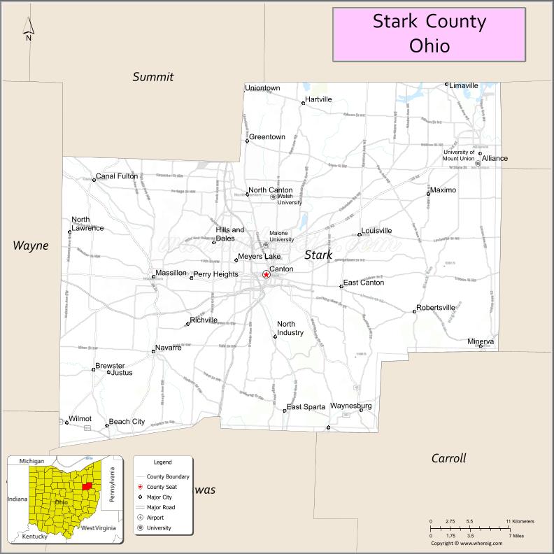
About Stark County Map, Ohio: The map showing the county boundary, county seat, major cities, highways, water bodies and neighbouring counties.
Ohio More Maps & Info
About Stark County, Ohio
Stark County is a county located in the U.S. state of Ohio. It's county seat is Canton. As per 2020 census, the population of Stark County is 373834 people and population density is square miles. According to the United States Census Bureau, the county has a total area of 576.14 sq mi (1,492 km2). Stark County was established on -33558.
Stark County Facts
| Continent | North America |
| Country | United States |
| State | Ohio |
| County Seat | Canton |
| Largest City/Town | Canton |
| Established | February 13, 1808 |
| Total Area | 581 sq mi (1,505 sq km) |
| Land Area | 575 sq mi (1,489 sq km) |
| Water Area | 6.1 sq mi (15.8 sq km) |
| Population | 374,853 (Census 2020) |
| Population Density | 652 people per sq mi |
| Time Zone | Eastern Time Zone (ET) |
| Major Highways | I-77, US-30, State Route 43, State Route 44, State Route 62 |
| Neighboring Counties | Summit County, Portage County, Mahoning County, Columbiana County, Carroll County, Tuscarawas County, Holmes County, Wayne County |
| Famous For | Pro Football Hall of Fame, manufacturing, historical sites |
| Top Attractions | Pro Football Hall of Fame, Canton Classic Car Museum, McKinley Presidential Library, Sippo Lake Park |
| Official Website | https://www.starkcountyohio.gov/ |
Cities and Towns in Stark County, Ohio
- Canton (county seat) – 70,872 (Census 2020)
- Massillon – 32,146 (Census 2020)
- Alliance – 21,672 (Census 2020)
- North Canton – 17,488 (Census 2020)
Roads and Highways in Stark County, Ohio
Stark County is well connected by highways that provide access to northeastern Ohio and beyond.
- I-77 – major north-south interstate connecting Cleveland to Akron and Canton
- US-30 – east-west highway linking Canton to Wooster and East Liverpool
- State Route 43 – connects Canton to Kent and Wayne County
- State Route 44 – runs north-south linking the county to Portage County
- State Route 62 – connects Canton to Alliance and Youngstown
Neighboring Counties of Stark County
- Summit County (northwest)
- Portage County (north)
- Mahoning County (northeast)
- Columbiana County (east)
- Carroll County (southeast)
- Tuscarawas County (south)
- Holmes County (southwest)
- Wayne County (west)
Top Attractions in Stark County, Ohio
Stark County offers cultural landmarks, parks, and family-friendly attractions.
- Pro Football Hall of Fame – major sports museum honoring football legends
- McKinley Presidential Library & Museum – dedicated to President William McKinley
- Canton Classic Car Museum – collection of historic and classic automobiles
- Sippo Lake Park – scenic park with trails and wildlife viewing
- Gervasi Vineyard – winery and resort with dining and events
- MAPS Air Museum – aviation museum with historic aircraft
- Downtown Canton – historic district with shops and entertainment
- Massillon Museum – art and history exhibits
Distance from Stark County to Nearby Cities
- Stark County to Akron – 20 mi (32 km)
- Stark County to Cleveland – 60 mi (97 km)
- Stark County to Columbus – 125 mi (201 km)
- Stark County to Youngstown – 50 mi (80 km)
- Stark County to Pittsburgh – 100 mi (161 km)
FAQs about Stark County
Stark County is located in northeastern Ohio.
It is known for the Pro Football Hall of Fame and its manufacturing history.
The population was 374,853 according to the 2020 Census.
The county seat is Canton.
Yes, the county offers museums, parks, and cultural attractions.
- Adams County Map
- Allen County Map
- Ashland County Map
- Ashtabula County Map
- Athens County Map
- Auglaize County Map
- Belmont County Map
- Brown County Map
- Butler County Map
- Carroll County Map
- Champaign County Map
- Clark County Map
- Clermont County Map
- Clinton County Map
- Columbiana County Map
- Coshocton County Map
- Crawford County Map
- Cuyahoga County Map
- Darke County Map
- Defiance County Map
- Delaware County Map
- Erie County Map
- Fairfield County Map
- Fayette County Map
- Franklin County Map
- Fulton County Map
- Gallia County Map
- Geauga County Map
- Greene County Map
- Guernsey County Map
- Hamilton County Map
- Hancock County Map
- Hardin County Map
- Harrison County Map
- Henry County Map
- Highland County Map
- Hocking County Map
- Holmes County Map
- Huron County Map
- Jackson County Map
- Jefferson County Map
- Knox County Map
- Lake County Map
- Lawrence County Map
- Licking County Map
- Logan County Map
- Lorain County Map
- Lucas County Map
- Madison County Map
- Mahoning County Map
- Marion County Map
- Medina County Map
- Meigs County Map
- Mercer County Map
- Miami County Map
- Monroe County Map
- Montgomery County Map
- Morgan County Map
- Morrow County Map
- Muskingum County Map
- Noble County Map
- Ottawa County Map
- Paulding County Map
- Perry County Map
- Pickaway County Map
- Pike County Map
- Portage County Map
- Preble County Map
- Putnam County Map
- Richland County Map
- Ross County Map
- Sandusky County Map
- Scioto County Map
- Seneca County Map
- Shelby County Map
- Stark County Map
- Summit County Map
- Trumbull County Map
- Tuscarawas County Map
- Union County Map
- Van Wert County Map
- Vinton County Map
- Warren County Map
- Washington County Map
- Wayne County Map
- Williams County Map
- Wood County Map
- Wyandot County Map
- Alabama Counties
- Alaska boroughs
- Arizona Counties
- Arkansas Counties
- California County Map
- Colorado Counties
- Connecticut Counties
- Delaware Counties
- Florida County Map
- Georgia County Map
- Hawaii Counties
- Idaho Counties
- Illinois Counties
- Indiana Counties
- Iowa Counties
- Kansas Counties
- Kentucky Counties
- Louisiana Counties
- Maine Counties
- Maryland Counties
- Massachusetts Counties
- Michigan County Map
- Minnesota Counties
- Mississippi Counties
- Missouri Counties
- Montana Counties
- Nebraska Counties
- Nevada Counties
- New York Counties
- New Hampshire Counties
- New Jersey Counties
- New Mexico Counties
- North Carolina Counties
- North Dakota Counties
- Ohio County Map
- Oklahoma Counties
- Oregon Counties
- Pennsylvania Counties
- Rhode Island Counties
- South Carolina Counties
- South Dakota Counties
- Map of Tennessee
- Texas County Map
- Utah Counties
- Vermont Counties
- Virginia Counties
- Washington Counties
- West Virginia Counties
- Wisconsin Counties
- Wyoming Counties