Map of Auglaize County - Auglaize County is a county located in the U.S. state of Ohio. Auglaize County Map showing cities, highways, important places and water bodies. Get Where is Auglaize County located in the map, major cities in Auglaize county, population, areas, and places of interest.
Map of Auglaize County, Ohio
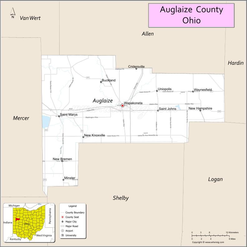
About Auglaize County Map, Ohio: The map showing the county boundary, county seat, major cities, highways, water bodies and neighbouring counties.
Ohio More Maps & Info
About Auglaize County, Ohio
Auglaize County is a county located in the U.S. state of Ohio. It's county seat is Wapakoneta. As per 2020 census, the population of Auglaize County is 46141 people and population density is square miles. According to the United States Census Bureau, the county has a total area of 401.25 sq mi (1,039 km2). Auglaize County was established on -18947.
Auglaize County Facts
| Continent | North America |
| Country | United States |
| State | Ohio |
| County Seat | Wapakoneta |
| Largest City/Town | Wapakoneta |
| Established | 1848 |
| Total Area | 402 sq mi |
| Land Area | 401 sq mi |
| Water Area | 1 sq mi |
| Population | 46,422 (Census 2020) |
| Population Density | 116 people per sq mi |
| Time Zone | Eastern (EST) |
| Major Highways | I-75, US-33, SR-65, SR-501 |
| Neighboring Counties | Allen County, Mercer County, Shelby County, Logan County, Hardin County |
| Famous For | Neil Armstrong birthplace, agriculture, small-town communities |
| Top Attractions | Neil Armstrong Air and Space Museum, Grand Lake St. Marys, Wapakoneta Historic District |
| Official Website | https://www.co.auglaize.oh.us |
Cities and Towns in Auglaize County, Ohio
- Wapakoneta (county seat) – 9,867 (Census 2020)
- Saint Marys – 8,332 (Census 2020)
- Minster – 2,805 (Census 2020)
- New Bremen – 3,033 (Census 2020)
Roads and Highways in Auglaize County, Ohio
Auglaize County is connected by major highways that link west-central Ohio to larger regional cities.
- Interstate 75 (I-75) – Major north-south corridor connecting Toledo and Cincinnati
- U.S. Route 33 (US-33) – Connects the county to Columbus and western Ohio
- State Route 65 (SR-65) – Runs through the county linking local communities
- State Route 501 (SR-501) – Serves rural areas within the county
Neighboring Counties of Auglaize County
- Allen County (west)
- Mercer County (north)
- Shelby County (east)
- Logan County (southeast)
- Hardin County (southwest)
Top Attractions in Auglaize County, Ohio
Auglaize County is known for its space history, lakes, and small-town charm.
- Neil Armstrong Air and Space Museum – Honors the first man on the moon
- Grand Lake St. Marys – Large inland lake for boating and fishing
- Wapakoneta Historic District – Downtown area with historic buildings and shops
- Auglaize County Historical Society Museum – Local history exhibits
- Frogtown Marina – Recreation area on Grand Lake
- Rotary Riverwalk Park – Scenic walking trails in Wapakoneta
- Saint Marys State Fish Hatchery (nearby) – Wildlife and education site
Distance from Auglaize County to Nearby Cities
- Wapakoneta to Dayton – 60 mi (97 km)
- Wapakoneta to Toledo – 110 mi (177 km)
- Wapakoneta to Columbus – 90 mi (145 km)
- Wapakoneta to Cincinnati – 120 mi (193 km)
- Wapakoneta to Lima – 20 mi (32 km)
FAQs about Auglaize County
Auglaize County is known for being the birthplace of Neil Armstrong and its agricultural communities.
Wapakoneta is the county seat of Auglaize County.
Yes, part of Grand Lake St. Marys is located in Auglaize County.
It is famous for Neil Armstrong’s birthplace and its space exploration history.
Visitors enjoy the Neil Armstrong Air and Space Museum, Grand Lake St. Marys, and historic downtown Wapakoneta.
- Adams County Map
- Allen County Map
- Ashland County Map
- Ashtabula County Map
- Athens County Map
- Auglaize County Map
- Belmont County Map
- Brown County Map
- Butler County Map
- Carroll County Map
- Champaign County Map
- Clark County Map
- Clermont County Map
- Clinton County Map
- Columbiana County Map
- Coshocton County Map
- Crawford County Map
- Cuyahoga County Map
- Darke County Map
- Defiance County Map
- Delaware County Map
- Erie County Map
- Fairfield County Map
- Fayette County Map
- Franklin County Map
- Fulton County Map
- Gallia County Map
- Geauga County Map
- Greene County Map
- Guernsey County Map
- Hamilton County Map
- Hancock County Map
- Hardin County Map
- Harrison County Map
- Henry County Map
- Highland County Map
- Hocking County Map
- Holmes County Map
- Huron County Map
- Jackson County Map
- Jefferson County Map
- Knox County Map
- Lake County Map
- Lawrence County Map
- Licking County Map
- Logan County Map
- Lorain County Map
- Lucas County Map
- Madison County Map
- Mahoning County Map
- Marion County Map
- Medina County Map
- Meigs County Map
- Mercer County Map
- Miami County Map
- Monroe County Map
- Montgomery County Map
- Morgan County Map
- Morrow County Map
- Muskingum County Map
- Noble County Map
- Ottawa County Map
- Paulding County Map
- Perry County Map
- Pickaway County Map
- Pike County Map
- Portage County Map
- Preble County Map
- Putnam County Map
- Richland County Map
- Ross County Map
- Sandusky County Map
- Scioto County Map
- Seneca County Map
- Shelby County Map
- Stark County Map
- Summit County Map
- Trumbull County Map
- Tuscarawas County Map
- Union County Map
- Van Wert County Map
- Vinton County Map
- Warren County Map
- Washington County Map
- Wayne County Map
- Williams County Map
- Wood County Map
- Wyandot County Map
- Alabama Counties
- Alaska boroughs
- Arizona Counties
- Arkansas Counties
- California County Map
- Colorado Counties
- Connecticut Counties
- Delaware Counties
- Florida County Map
- Georgia County Map
- Hawaii Counties
- Idaho Counties
- Illinois Counties
- Indiana Counties
- Iowa Counties
- Kansas Counties
- Kentucky Counties
- Louisiana Counties
- Maine Counties
- Maryland Counties
- Massachusetts Counties
- Michigan County Map
- Minnesota Counties
- Mississippi Counties
- Missouri Counties
- Montana Counties
- Nebraska Counties
- Nevada Counties
- New York Counties
- New Hampshire Counties
- New Jersey Counties
- New Mexico Counties
- North Carolina Counties
- North Dakota Counties
- Ohio County Map
- Oklahoma Counties
- Oregon Counties
- Pennsylvania Counties
- Rhode Island Counties
- South Carolina Counties
- South Dakota Counties
- Map of Tennessee
- Texas County Map
- Utah Counties
- Vermont Counties
- Virginia Counties
- Washington Counties
- West Virginia Counties
- Wisconsin Counties
- Wyoming Counties