Map of Logan County - Logan County is a county located in the U.S. state of Ohio. Logan County Map showing cities, highways, important places and water bodies. Get Where is Logan County located in the map, major cities in Logan county, population, areas, and places of interest.
Map of Logan County, Ohio
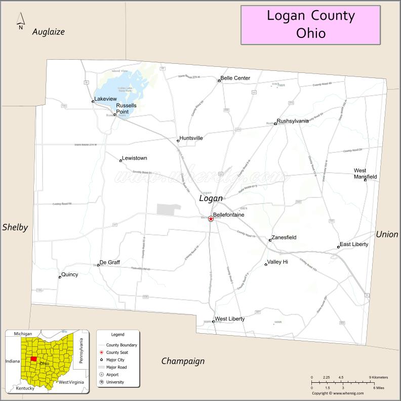
About Logan County Map, Ohio: The map showing the county boundary, county seat, major cities, highways, water bodies and neighbouring counties.
Ohio More Maps & Info
About Logan County, Ohio
Logan County is a county located in the U.S. state of Ohio. It's county seat is Bellefontaine. As per 2020 census, the population of Logan County is 46035 people and population density is square miles. According to the United States Census Bureau, the county has a total area of 458.44 sq mi (1,187 km2). Logan County was established on -29889.
Logan County Facts
| Continent | North America |
| Country | United States |
| State | Ohio |
| County Seat | Bellefontaine |
| Largest City/Town | Bellefontaine |
| Established | March 1, 1818 |
| Total Area | 467 sq mi (1,209 sq km) |
| Land Area | 459 sq mi (1,189 sq km) |
| Water Area | 8.2 sq mi (21.2 sq km) |
| Population | 48,245 (Census 2020) |
| Population Density | 105 people per sq mi |
| Time Zone | Eastern Time Zone (ET) |
| Major Highways | US-33, US-68, State Route 47, State Route 117, State Route 274 |
| Neighboring Counties | Auglaize County, Hardin County, Union County, Champaign County, Shelby County, Miami County |
| Famous For | Indian Lake, highest point in Ohio (Campbell Hill), outdoor recreation |
| Top Attractions | Indian Lake State Park, Campbell Hill, Piatt Castles, Bellefontaine Historic District |
| Official Website | https://www.co.logan.oh.us/ |
Cities and Towns in Logan County, Ohio
- Bellefontaine (county seat) – 13,069 (Census 2020)
- Russells Point – 1,391 (Census 2020)
- Lakeview – 1,104 (Census 2020)
- West Liberty – 1,805 (Census 2020)
Roads and Highways in Logan County, Ohio
Logan County is served by several highways that connect it to central and western Ohio.
- US-33 – major route connecting Bellefontaine to Columbus and Lima
- US-68 – north-south highway linking the county to Findlay and Springfield
- State Route 47 – runs east-west connecting Bellefontaine to Sidney
- State Route 117 – links Huntsville to surrounding rural areas
- State Route 274 – connects Indian Lake communities to nearby towns
Neighboring Counties of Logan County
- Auglaize County (northwest)
- Shelby County (north)
- Hardin County (northeast)
- Union County (east)
- Champaign County (south)
- Miami County (southwest)
Top Attractions in Logan County, Ohio
Logan County offers lakeside recreation, historic sites, and scenic countryside.
- Indian Lake State Park – popular destination for boating, fishing, and camping
- Campbell Hill – highest natural point in Ohio
- Piatt Castles – historic mansions with unique architecture and tours
- Bellefontaine Historic District – charming downtown with shops and history
- Indian Lake – major attraction for water activities and relaxation
- Mad River Mountain – popular ski and snowboarding destination in winter
- Logan County History Center – showcases local history and heritage
- Mary Rutan Park – local park with walking trails and green space
Distance from Logan County to Nearby Cities
- Logan County to Columbus – 50 mi (80 km)
- Logan County to Dayton – 60 mi (97 km)
- Logan County to Lima – 50 mi (80 km)
- Logan County to Springfield – 30 mi (48 km)
- Logan County to Cincinnati – 110 mi (177 km)
FAQs about Logan County
Logan County is located in west-central Ohio.
It is known for Indian Lake, Campbell Hill, and outdoor recreation.
The population was 48,245 according to the 2020 Census.
The county seat is Bellefontaine.
Yes, the county offers lakes, parks, and recreational areas.
- Adams County Map
- Allen County Map
- Ashland County Map
- Ashtabula County Map
- Athens County Map
- Auglaize County Map
- Belmont County Map
- Brown County Map
- Butler County Map
- Carroll County Map
- Champaign County Map
- Clark County Map
- Clermont County Map
- Clinton County Map
- Columbiana County Map
- Coshocton County Map
- Crawford County Map
- Cuyahoga County Map
- Darke County Map
- Defiance County Map
- Delaware County Map
- Erie County Map
- Fairfield County Map
- Fayette County Map
- Franklin County Map
- Fulton County Map
- Gallia County Map
- Geauga County Map
- Greene County Map
- Guernsey County Map
- Hamilton County Map
- Hancock County Map
- Hardin County Map
- Harrison County Map
- Henry County Map
- Highland County Map
- Hocking County Map
- Holmes County Map
- Huron County Map
- Jackson County Map
- Jefferson County Map
- Knox County Map
- Lake County Map
- Lawrence County Map
- Licking County Map
- Logan County Map
- Lorain County Map
- Lucas County Map
- Madison County Map
- Mahoning County Map
- Marion County Map
- Medina County Map
- Meigs County Map
- Mercer County Map
- Miami County Map
- Monroe County Map
- Montgomery County Map
- Morgan County Map
- Morrow County Map
- Muskingum County Map
- Noble County Map
- Ottawa County Map
- Paulding County Map
- Perry County Map
- Pickaway County Map
- Pike County Map
- Portage County Map
- Preble County Map
- Putnam County Map
- Richland County Map
- Ross County Map
- Sandusky County Map
- Scioto County Map
- Seneca County Map
- Shelby County Map
- Stark County Map
- Summit County Map
- Trumbull County Map
- Tuscarawas County Map
- Union County Map
- Van Wert County Map
- Vinton County Map
- Warren County Map
- Washington County Map
- Wayne County Map
- Williams County Map
- Wood County Map
- Wyandot County Map
- Alabama Counties
- Alaska boroughs
- Arizona Counties
- Arkansas Counties
- California County Map
- Colorado Counties
- Connecticut Counties
- Delaware Counties
- Florida County Map
- Georgia County Map
- Hawaii Counties
- Idaho Counties
- Illinois Counties
- Indiana Counties
- Iowa Counties
- Kansas Counties
- Kentucky Counties
- Louisiana Counties
- Maine Counties
- Maryland Counties
- Massachusetts Counties
- Michigan County Map
- Minnesota Counties
- Mississippi Counties
- Missouri Counties
- Montana Counties
- Nebraska Counties
- Nevada Counties
- New York Counties
- New Hampshire Counties
- New Jersey Counties
- New Mexico Counties
- North Carolina Counties
- North Dakota Counties
- Ohio County Map
- Oklahoma Counties
- Oregon Counties
- Pennsylvania Counties
- Rhode Island Counties
- South Carolina Counties
- South Dakota Counties
- Map of Tennessee
- Texas County Map
- Utah Counties
- Vermont Counties
- Virginia Counties
- Washington Counties
- West Virginia Counties
- Wisconsin Counties
- Wyoming Counties